Salorno
| Salorno | |
|---|---|
| Comune | |
| Comune di Salorno Gemeinde Salurn | |
|
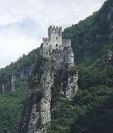
Salorno in the Adige valley, view from the Haderburg | |
 Salorno Location of Salorno in Italy | |
| Coordinates: 46°14′N 11°12′E / 46.233°N 11.200°ECoordinates: 46°14′N 11°12′E / 46.233°N 11.200°E | |
| Country | Italy |
| Region | Trentino-Alto Adige/Südtirol |
| Province / Metropolitan city | South Tyrol (BZ) |
| Frazioni | Gfrill (Cauria), Buchholz (Pochi) |
| Government | |
| • Mayor | Roland Lazzeri (South Tyrolean People's Party) |
| Area | |
| • Total | 33.2 km2 (12.8 sq mi) |
| Elevation | 224 m (735 ft) |
| Population (31 Dec. 2011) | |
| • Total | 3,591 |
| • Density | 110/km2 (280/sq mi) |
| Demonym(s) |
German: Salurner Italian: salornesi |
| Time zone | CET (UTC+1) |
| • Summer (DST) | CEST (UTC+2) |
| Postal code | 39040 |
| Dialing code | 0471 |
| Website | Official website |

Salorno (Italian pronunciation: [saˈlorno]; German: Salurn [saˈlʊrn]) is the southernmost comune (municipality) in South Tyrol in northern Italy, located about 30 kilometres (19 mi) southwest of the city of Bolzano. It is one of only five mainly Italian speaking municipalities in South Tyrol.
Geography
The village centre is located on a scree in the Adige (Etsch) valley, about 20 kilometres (12 mi) northeast of the city of Trento and about 30 kilometres (19 mi) southwest of Bolzano. Parts of the municipal area belong to the Naturpark Trudner Horn nature reserve, which is part of the Natura 2000 network. Salorno station is a stop on the Brenner Railway line from Innsbruck to Verona.

In the northwest Salorno borders the South Tyrolean municipalities of Kurtinig, Margreid, Montan, and Neumarkt. In the east and south it borders the Trentino municipalities of Capriana, Cembra, Faver, Giovo, Grauno, Grumes, Mezzocorona, Roverè della Luna and Valda. The Salurner Klause (Chiusa di Salorno), a narrow section of the Adige Valley between the Fiemme Mountains and the Nonsberg Group, marks the southern border of the South Tyrolean Unterland. Since about 1600 a German-Italian language border solidified here, a circumstance which received a nationalist emphasis by the 19th century, as referred to in the Bozner Bergsteigerlied.
The municipality contains the frazioni (subdivisions, mainly villages and hamlets) Gfrill (Italian: Cauria) and Buchholz (Pochi). As of 31 December 2011, Salorno had a population of 3,591 and an area of 33.2 square kilometres (12.8 sq mi).[1]
History
″Salurn un gros bourg aux confins d'Allemagne e d'Italie dans le Tirol, dont il fait la séparation.″
(Denis Diderot: Encyclopédie, 40, 548.)
A settlement since the days of the Roman Empire, Salorno in the Kingdom of the Lombards was first mentioned in a 580 deed as Salurnis during the Rule of the Dukes, when Duke Euin of Trent fought against the Frankish troops of the invading Merovingian kings Guntram and Childebert II.
The village is best known for the ruins of the medieval castle Haderburg (Italian: Castello di Salorno). First mentioned in a 1053 travelogue, it is situated on a limestone rock high above the Salurner Klause bottleneck of the Adige Valley. In 1158 the local Counts of Eppan had two cardinals of the Roman Curia on their way to the court of Emperor Frederick Barbarossa attacked and raided. Frederick's cousin Henry the Lion launched a punitive expedition, whereby the castle was demolished. It was rebuilt afterwards and about 1200 was acquired by the Counts of Tyrol. It was purchased by Count Meinhard II of Gorizia-Tyrol in 1284, besieged and occupied by Duke Louis V of Bavaria in 1349, and finally bequested to the Austrian House of Habsburg in 1363. Emperor Maximilian I had the fortifications enlarged, however, the castle lost its strategical significance soon afterwards and decayed. Since 1648 the ruins are in possession of the Venetian counts of Zenobio-Albrizzi.
After World War I and the dissolution of Austria-Hungary, Salorno was annexed to Italy together with the rest of South Tyrol and other areas of the Austrian territory, as consequence of the Treaty of Saint-Germain-en-Laye on 10 October 1920. According to the census of 1921 the majority of the population of Salorno declared themselves as German speaking. After that a governmental commission adjusted the result by modifying the declaration of people whose family name sounded Italian. Salorno and other municipalities of South Tyrol have since then an Italian speaking majority. The effective Italianization conducted by the fascist Regime changed definitively the proportion between the languages.[3] Only 37% of the inhabitants speak mainly German today.
Coat of arms
The emblem is argent a pile reversed and chief azure. It is the insignia of the Lords of Graland who obtained the village in the thirteenth century. The emblem was adopted in 1971.[4]
Society
Linguistic distribution
Since 2001 Salorno's population has risen strongly. According to the 2011 census, 61.85% of the population speak Italian, 37.74% German and 0.40% Ladin as first language.[5]
| Language | 2001[6] | 2011[5] |
|---|---|---|
| German | 37.43% | 37.74% |
| Italian | 62.19% | 61.85% |
| Ladin | 0.39% | 0.40% |
Demographic evolution


Notable people
- Perkeo of Heidelberg (1702–1735), court jester
- Hartmann von An der Lan-Hochbrunn (1863–1914), composer, organist and director
- Tomas Ress (born 1980), basketball player
References
- ↑ All demographics and other statistics: Italian statistical institute Istat.
- ↑ Obermair 2001, p. 179
- ↑ Gemeinde Kurtinig (ed.): Kurtinig – Ein Dorf an der Sprachgrenze in Vergangenheit und Gegenwart. Bozen-Bolzano: Athesia, 2000. ISBN 8870149838
- ↑ Heraldry of the World: Salurn
- 1 2 "Volkszählung 2011/Censimento della popolazione 2011". astat info. Provincial Statistics Institute of the Autonomous Province of South Tyrol (38): 6–7. June 2012. Retrieved 2012-06-14.
- ↑ Oscar Benvenuto (ed.): "South Tyrol in Figures 2008", Provincial Statistics Institute of the Autonomous Province of South Tyrol, Bozen/Bolzano 2007, p. 17, table 10
Further reading
- Stolz, Otto (1946). "Neumarkt und Salurn in ihren Beziehungen zur Tiroler Landesgeschichte". Der Schlern. 20: 292–99.
- Obermair, Hannes (2001). online "Soziale Produktion von Recht? Das Weistum des Gerichts Salurn in Südtirol von 1403" Check
|url=value (help) (PDF). Concilium medii aevi. 4: 179–208. ISSN 1437-904X. - Landi, Walter (2010). Haderburg. Die Feste an der Salurner Klause (Burgen, 5). Regensburg: Schnell & Steiner. ISBN 978-3-7954-2163-2.
External links
![]() Media related to Salorno at Wikimedia Commons
Media related to Salorno at Wikimedia Commons
- (Italian) (German) Homepage of the municipality