Trustom Pond
| Trustom Pond | |
|---|---|
 | |
| Location | South Kingstown Washington County, Rhode Island |
| Coordinates | 41°22′17″N 71°34′57″W / 41.3714905°N 71.5825599°WCoordinates: 41°22′17″N 71°34′57″W / 41.3714905°N 71.5825599°W |
| Type | saline |
| Primary inflows | precipitation, groundwater |
| Catchment area | 794 acres (321 ha)[1] |
| Basin countries | United States |
| Surface area | 180 acres (73 ha)[1] |
| Average depth | 1.3 ft (0.40 m)[1] |
| Surface elevation | 0 ft [2] |
| Website | Trustom Pond National Wildlife Refuge |
| References | [1][2] |
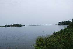
Trustom Pond is a closed lagoon in South Kingstown, Washington County, Rhode Island, United States.[3] It is one of nine coastal lagoons (referred to as "salt ponds" by locals) in southern Rhode Island.[4][5] It has a surface area of 800 acres (320 ha), and is the only undeveloped salt pond in the state.[6][7] The pond averages 1.3 feet (0.40 m) deep, and has a salinity level of 5 parts per thousand. It is non-tidal, except when breached by storms.[1] The water directly receives about 219,844,022 US gallons (832,200,150 L) of precipitation per year, with an estimated 796,215 US gallons (3,014,000 L) in daily groundwater flow.[8] No streams flow into the pond, though a nearby stream "captures water that otherwise would have flowed to Trustom Pond".[9]
Trustom Pond National Wildlife Refuge is a National Wildlife Refuge, inhabited by over 300 species of birds, 40 species of mammals, and 20 species of reptiles and amphibians.[7] As such, it is a popular bird-watching destination.[10] In 1987, 365 acres (148 ha) of land were donated to the U.S. Fish and Wildlife Service; subsequent donations and purchases raised the protected area to 800 acres (320 ha), with current plans for expansion. The wildlife refuge receives approximately 50,000 visitors annually.[7] The Trustom Pond National Wildlife Refuge includes 3 miles (4.8 km) of foot trails, surrounded by fields, shrublands, woodlands and small freshwater ponds.[11] Wildlife managers create breachways to the Block Island Sound, lowering water levels and creating mudflats which become feeding areas for waders.[12]
See also
References
- 1 2 3 4 5 "Trustom Pond General Features Data". Rhode Island South Shore Sea Grant. Archived from the original on September 8, 2008. Retrieved 2009-05-25., quoting RIGIS 2001 (area) and Lee 1980 (salinity)
- 1 2 U.S. Geological Survey Geographic Names Information System: Trustom Pond
- ↑ "Salt Ponds of Rhode Island" (PDF). Rhode Island Sea Grant. Archived from the original (PDF) on May 17, 2008. Retrieved 2009-05-25.
- ↑ Donald Wyatt (1995). "Rhode Island's last execution". FAQs.org. Retrieved 2009-05-25.
- ↑ S.W. Nixon and B. A. Buckley (2007). "Nitrogen Inputs to Rhode Island Coastal Salt – Too Much of a Good Thing" (PDF). Rhode Island Department of Environmental Management. Retrieved 2009-05-25.
- ↑ "Trustom Pond National Wildlife Refuge". VisitRhodeIsland.com. Retrieved 2009-05-25.
- 1 2 3 "Trustom Pond National Wildlife Refuge". U.S. Fish and Wildlife Service. Retrieved 2009-05-25.
- ↑ "Trustom Pond Freshwater Input Data". Rhode Island South Shore Sea Grant. Archived from the original on July 16, 2011. Retrieved 2009-05-25.
- ↑ USGS. Hydrogeology and simulated groundwater flow in the Salt Pond region of southern Rhode Island. DIANE Publishing. p. 30. ISBN 1-4223-2575-X.
- ↑ "Bird Watching & Wildlife Refuges". South County Tourism Council. Retrieved 2009-05-25.
- ↑ "Trustom Pond National Wildlife Refuges". GORP. Retrieved 2009-05-25.
- ↑ Mark Damian Duda and Robert Field (1995). Watching Wildlife. Globe Pequot. p. 80. ISBN 1-56044-315-4.
External links
- U.S. Geological Survey Geographic Names Information System: Trustom Pond
- Trustom Pond National Wildlife Refuge
- Trustom Pond map
| Wikimedia Commons has media related to Rhode Island salt ponds. |
Rhode Island's salt ponds | ||
|---|---|---|