Ninigret National Wildlife Refuge
| Ninigret National Wildlife Refuge | |
|---|---|
|
IUCN category IV (habitat/species management area) | |
|
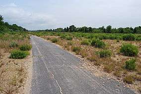
Part of the National Wildlife Refuge in August 2010 | |
 Map of the United States | |
| Location | Charlestown, Washington County, Rhode Island, United States |
| Nearest city | Quonochontaug, Rhode Island |
| Coordinates | 41°20′42″N 71°40′51″W / 41.3451°N 71.68089°WCoordinates: 41°20′42″N 71°40′51″W / 41.3451°N 71.68089°W[1] |
| Area | 900 acres (3.6 km2) |
| Established | 1970 |
| Governing body | U.S. Fish and Wildlife Service |
| Website | Ninigret National Wildlife Refuge |
The Ninigret National Wildlife Refuge is a National Wildlife Refuge situated along the shore of Ninigret Pond.[2] The refuge, characterized by salt marshes, kettle ponds, freshwater wetlands, maritime shrublands and forests, is seasonally inhabited by over 250 species of birds. The area was originally used for farming, prior to being utilized in World War II as a Naval Auxiliary landing field. Upon the transfer of 27.5 acres (11.1 ha) of land to the U.S. Fish and Wildlife Service, the refuge was designated in 1970. Subsequent transfers and purchases increased the protected area to approximately 900 acres (360 ha).[3] During the winter months, black ducks, Canada geese, and diving ducks are especially prominent on the pond, while various species of migrating raptors are also common. Wildlife refuge staff also maintain a piping plover nesting program.[4]
The refuge encompasses land of the former Naval Auxiliary Air Station Charlestown.
References
- ↑ "Ninigret National Wildlife Refuge". Geographic Names Information System. United States Geological Survey.
- ↑ "Ninigret National Wildlife Refuge". VisitRhodeIsland.com. Retrieved June 12, 2009.
- ↑ "Ninigret National Wildlife Refuge". U.S. Fish and Wildlife Service. Retrieved June 12, 2009.
- ↑ "Activities within Ninigret National Wildlife Refuge". Wildernet. Retrieved June 12, 2009.
![]() This article incorporates public domain material from websites or documents of the United States Fish and Wildlife Service.
This article incorporates public domain material from websites or documents of the United States Fish and Wildlife Service.