Troy Hill Incline
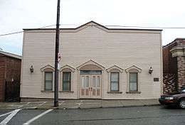
The Troy Hill Incline, also known as the Mount Troy Incline, was a funicular railway located in old Allegheny, Pennsylvania, which is now the North Side of the city of Pittsburgh. Built by Gustav Lindenthal[1][2] or Samuel Diescher,[3] the incline was one of only a few funiculars constructed on the north side of Pittsburgh. It began construction in August 1887, and after considerable delay, opened on 20 September 1888.[1] The incline ascended from Ohio Street near the end of the second 30th Street Bridge to Lowrie Street on the crest of Troy Hill. A building now standing at 1733 Lowrie Street was long thought to have been the summit station, but later research found that the building did not appear on maps until well after the purported closure of the incline in 1898.[4] The incline's length measured 370 feet (113 m), with a forty-seven percent (47%) gradient. The cost of construction was about $94,047.[5]
See also
References
- 1 2 "Open for Business". The Pittsburg Press. 20 Sep 1888. p. 1.
- ↑ "New Troy Hill Incline". The Pittsburg Press. 14 Jun 1888. p. 1.
- ↑ "The Inclined Planes". The Street Railway Journal Souvenir: 39. October 1891.
- ↑ Jones, Diana Nelson (10 August 2015). "Research changes information on Troy Hill incline". Pittsburgh Post Gazette. Retrieved 11 August 2015.
- ↑ A Century of Inclines. Pittsburgh: Society for the Preservation of the Duquesne Heights Incline. 1976. p. 15.
Sources
- A Century of Inclines, The Society for the Preservation of the Duquesne Incline.
Coordinates: 40°27′52″N 79°58′55″E / 40.464514°N 79.981844°E