Trail, Missouri
| Trail, Missouri | |
|---|---|
| Community | |
 Trail, Missouri Location of Trail, Missouri | |
| Coordinates: 36°46′5″N 92°17′43″W / 36.76806°N 92.29528°WCoordinates: 36°46′5″N 92°17′43″W / 36.76806°N 92.29528°W[1] | |
| Country | U. S. A. |
| State | Missouri |
| County | Ozark County |
| Elevation[1] | 230 m (750 ft) |
| Time zone | CST (UTC-6) |
| • Summer (DST) | CDT (UTC-5) |
Trail is an unincorporated community in northern Ozark County.[2] It is located about twenty-two miles northeast of Gainesville. Access is from Missouri Route 14 in Douglas County south via route AC. The village site is located adjacent to Trail Creek. Trail Creek flows into Bryant Creek about one mile to the southwest. The Trail cemetery lies about a mile to the northeast along Trail Creek.[1]
History
A post office called Toledo was established in 1890, and remained in operation until 1963.[3] The community name was for the family name of local residents.[4]
References
- 1 2 3 Gentryville, Missouri, 7.5 Minute Topographic Quadrangle, USGS, 1973
- ↑ U.S. Geological Survey Geographic Names Information System: Trail, Missouri
- ↑ "Post Offices". Jim Forte Postal History. Retrieved 27 November 2016.
- ↑ "Ozark County Place Names, 1928–1945". The State Historical Society of Missouri. Archived from the original on June 24, 2016. Retrieved November 27, 2016.
Municipalities and communities of Ozark County, Missouri, United States | ||
|---|---|---|
| Cities | 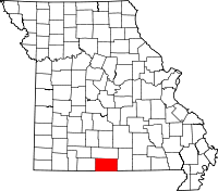 | |
| Villages | ||
| Townships |
| |
| CDPs | ||
| Other unincorporated communities | ||
| Ghost towns | ||
This article is issued from Wikipedia - version of the 11/28/2016. The text is available under the Creative Commons Attribution/Share Alike but additional terms may apply for the media files.