Tiadaghton State Forest
| Tiadaghton State Forest | |
|---|---|
| Pennsylvania State Forest | |
| Managed Resource Protected Area (IUCN VI) | |
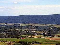
 Tiadaghton State Forest: White Deer Hole Creek near the Fourth Gap of South White Deer Ridge, Washington Township, Lycoming County, Pennsylvania | |
| Named for: Tiadaghton, an Iroquois name for Pine Creek | |
| Country | United States |
| State | Pennsylvania |
| Counties | Clinton, Lycoming, Potter, Tioga, Union |
| Location | |
| - coordinates | 41°09′40″N 77°02′21″W / 41.16111°N 77.03917°WCoordinates: 41°09′40″N 77°02′21″W / 41.16111°N 77.03917°W |
| - elevation | 1,493 ft (455.1 m) |
| Area | 215,500 acres (87,210 ha) |
| Managed by | Pennsylvania Department of Conservation and Natural Resources |
 Tiadaghton State Forest | |
 Location of Tiadaghton State Forest's headquarters in Pennsylvania | |
| Website : Tiadaghton State Forest | |
Tiadaghton State Forest is a Pennsylvania State Forest in the Pennsylvania Bureau of Forestry District #12. The forest is chiefly in western and southern Lycoming County, with small portions in Clinton, Potter, Tioga, and Union Counties.
As of July 1, 2005 the state forest lands in eastern Lycoming County, which had been part of Tiadaghton State Forest, became part of the new Loyalsock State Forest. The main office for district #12 is in South Williamsport, in Lycoming County, Pennsylvania in the United States. There are plans to move it to the Pine Creek valley, perhaps to the village of Waterville. Tiadaghton is the Iroquois name for Pine Creek, but its meaning is unknown.
History
As the timber was exhausted and the land burned, many companies simply abandoned their holdings.[1] Conservationists like Dr. Joseph Rothrock became concerned that the forests would not regrow if they were not managed properly. They called for the state to purchase land from the lumber companies and for a change in the philosophy of forest management. In 1895 Rothrock was appointed the first commissioner of the Pennsylvania Department of Forests and Waters, the forerunner of today's Department of Conservation and Natural Resources. In 1897 the Pennsylvania General Assembly passed legislation which authorized the purchase of "unseated lands for forest reservations" and the first Pennsylvania state forest lands were acquired the following year.[2]
On July 13, 1898, the state bought a 409-acre (166 ha) tract of land in Cummings Township for $72.99 ($2080 in 2016 terms).[3] This was the first purchase for what became Tiadaghton State Forest, which surrounds the park. The state forest grew to 66,000 acres (27,000 ha) by 1908, and over 160,000 acres (65,000 ha) in 1933.[4] Most of the major purchases for it were made between 1900 and 1935.[5]
2005 Realignment
Prior to the July 1, 2005 realignment of Pennsylvania State Forest Districts, Tiadaghton State Forest included all state forest lands in Lycoming County and encompassed 215,500 acres (87,210 ha). After realignment, the state forest tracts in eastern Lycoming County became part of the new Loyalsock State Forest. The District #12 office will also move from South Williamsport to Waterville, at the confluence of Little Pine Creek and Pine Creek, where the largest part of the forest is now located. The southern tracts are along Bald Eagle Mountain, North White Deer Ridge, South White Deer Ridge, and the White Deer Hole Creek watershed.
As of 2009, the Tiadaghton State Forest covered 146,500 acres (59,300 ha), chiefly in Lycoming County with small tracts in Clinton, Potter, Tioga, and Union Counties. The largest section of the state forest consists of 105,000 acres (42,000 ha) in the Pine Creek valley.[5]
Other attractions
Hiking
- Black Forest Trail; loop trail, 42.1 miles (67.8 km) long, west of Pine Creek in northwest Lycoming County
- Golden Eagle Trail; loop trail, 8.9 miles (14.3 km) long, east of Pine Creek in northwest Lycoming County
- Mid State Trail; 306 miles (492 km) north-south across Pennsylvania from near the Maryland border to the West Rim Trail in Tioga county
- Pine Creek Trail; 62 miles (100 km) rail trail from Jersey Shore, Pennsylvania north along Pine Creek to Wellsboro Junction in Tioga county and Tioga State Forest
Natural areas
- Algerine Swamp Natural Area; 84 acres (34 ha)
- Bark Cabin Natural Area; a 73-acre (30 ha) stand of old growth Eastern Hemlock, Northern Red Oak, White Ash, Bigtooth Aspen, and Hickories,[6] and the Mid State Trail
- Miller Run Natural Area; 4,000 acres (1,619 ha) oak and hardwood forest, three streams
- Red Pine Natural Area; 10 acres (4.0 ha) with a stand of old growth red pine.
- Torbert Island Natural Area; 54 acres (22 ha), an island in Pine Creek.
Wild Areas
- Algerine Wild Area; 3,700 acres (1,497 ha) with the Black Forest Trail
- Wolf Run Wild Area; 6,900 acres (2,792 ha) with the Golden Eagle Trail
Nearby state parks
- Little Pine State Park (Lycoming County)
- Ravensburg State Park (Clinton County)
- Susquehanna State Park (Lycoming County)
- Upper Pine Bottom State Park (Lycoming County)
Neighboring state forest districts
- Tioga State Forest (north)
- Loyalsock State Forest (east)
- Weiser State Forest (southwest)
- Bald Eagle State Forest (south)
- Sproul State Forest (west)
- Susquehannock State Forest (northwest)
References
- ↑ Owlett, Steven E. (1993). "The Death of a Forest". Seasons Along The Tiadaghton: An Environmental History of the Pine Creek Gorge (1st ed.). Petaluma, California: Interprint. pp. 53–62. ISBN 0-9635905-0-2.
- ↑ "History of the William Penn State Forest". Pennsylvania Department of Conservation and Natural Resources. Archived from the original on 2007-08-23. Retrieved March 4, 2014.
- ↑ "Consumer Price Index (Estimate) 1800-2008". Federal Reserve Bank of Minneapolis. 2009. Retrieved February 25, 2009.
- ↑ Thorpe, R.R. (1997). The Crown Jewel of Pennsylvania: The State Forest System. Pennsylvania Forestry Association, Pennsylvania Department of Conservation and Natural Resources and the U.S. Forest Service. pp. 68–70. OCLC 37033507.
- 1 2 A Public Use Map for Tiadaghton State Forest (Map). Pennsylvania Department of Conservation and Natural Resources, Bureau of Forestry. June 2009. Note: This is a map on one side, with a guide to the state forest and its resources on the other side
- ↑ Mary Byrd Davis (23 January 2008). "Old Growth in the East: A Survey. Pennsylvania" (PDF).
- "Tiadaghton State Forest". Pennsylvania Department of Conservation and Natural Resources. Retrieved 2006-07-14. Note: As of July 2006, this web page has not been updated to reflect the Pennsylvania State Forest Districts realignment.
- "DCNR REALIGNING FOREST DISTRICTS". Pennsylvania Department of Conservation and Natural Resources. June 2005. Archived from the original on March 4, 2014. Retrieved 2006-07-14.
- "State Forest Districts". Pennsylvania Department of Conservation and Natural Resources. Archived from the original on 2006-05-15. Retrieved 2006-07-14. Note: Map showing districts after the July 1, 2005 realignment
- "National & State Forest Hiking Trails". Pennsylvania Department of Conservation and Natural Resources. Retrieved 2006-07-14.