Brandywine Creek (Christina River)
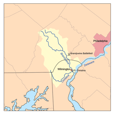

Brandywine Creek[1][2] (also called the Brandywine River) is a tributary of the Christina River in southeastern Pennsylvania and northern Delaware in the United States. The Lower Brandywine (the main stem) is 20.4 miles (32.8 km) long[3] and is a designated Pennsylvania Scenic River with several tributary streams. The East Branch and West Branch of the creek originate within 2 miles (3 km) of each other on the slopes of Welsh Mountain in Honey Brook Township, Pennsylvania, about 20 miles (32 km) northwest of their confluence.
The mouth of the creek on the Christina River in present-day Wilmington, Delaware, is the site of the New Sweden colony, where colonists first landed on March 29, 1638. The Battle of Brandywine was fought around the creek near Chadds Ford, Pennsylvania, on September 11, 1777, during the American Revolution. Water powered gristmills in Brandywine Village, near the creek mouth, and the nearby DuPont gunpowder mill were important in developing American industry before the introduction of steam power.
Course
The headwaters of both the East Branch[4] and West Branch[5] of Brandywine Creek are in western Chester County, Pennsylvania, near Honey Brook. The East Branch and West Branch flow southeast for 27.4 miles (44.1 km) and 33.1 miles (53.3 km), respectively,[3] to their confluence about 10 miles (16 km) southeast of Coatesville, between East Bradford Township and Pocopson Township. The combined drainage of the East Branch and West Branch, downstream of the confluence, is defined as Brandywine Creek and continues to flow southeast through Chester County, past Chadds Ford,[6] Delaware County, Pennsylvania then enters the state of Delaware about 5 miles (8 km) north of Wilmington.

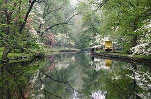
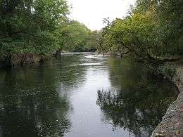
The creek continues south through First State National Historical Park and Brandywine Creek State Park, into Wilmington,[7] where it flows through Brandywine Park near the city center. Brandywine Creek joins the Christina River 1 mile (1.6 km) east of downtown Wilmington and about 2 miles (3 km) upstream from the mouth of the Christina, which also includes flows from the White Clay Creek[8] and Red Clay Creek[9] basins, and finally discharges into the Delaware River estuary.[10] The confluence of the Christina and Delaware rivers is the approximate dividing point between the freshwater Delaware River and the saltwater Delaware Bay.[11]
In Pennsylvania, Chadds Ford, Elam, Downingtown, Unionville, and parts of West Chester, are all in the Brandywine Valley, as well as the Delaware towns of Centreville, Greenville, Montchanin, Hockessin, and Yorklyn. Nearby Avondale (in the White Clay Creek basin) and Kennett Square, Pennsylvania (in the Red Clay Creek basin) are often considered part of the Brandywine Valley.[12]
History
Native Americans of the Algonquian-speaking Lenape (or Delaware) Nation lived in the area between the Hudson River Valley and southern Delaware before the European settlement. They lived by hunting, farming corn, beans, and squash, and by fishing. The Brandywine had an especially rich shad fishery. The Lenape called the creek Wauwaset, Wawasiungh, or Wawassan, and other Native American names for it included Suspecough and Trancocopanican.[13][14]
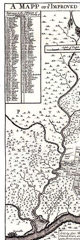
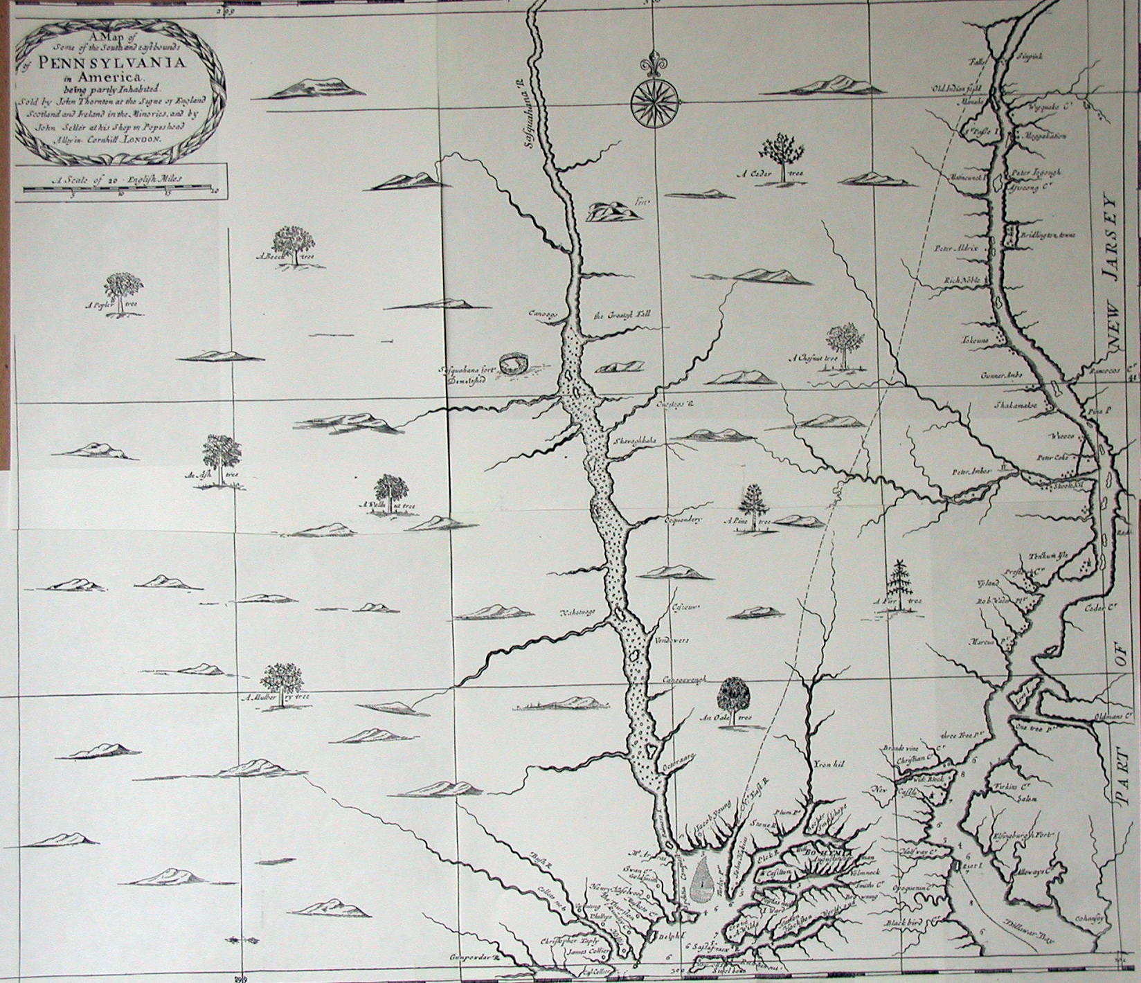
The first European settlement on the Brandywine was Swedish. On March 29, 1638, Peter Minuit, who had earlier explored the area for the Dutch, founded the colony of New Sweden near the confluence of the Christina and Brandywine, at Fort Christina, in present-day Wilmington. About 600 Swedes, Finns, and Dutch settled in New Sweden.[15] They tended to settle along the Delaware River rather than move inland along the Brandywine and are credited with introducing the log cabin into America.[12] They called the creek Fiskiekylen, or "Fish Creek", and the Dutch heritage is also reflected in Fiske Creek and variant names using the Dutch word "Kill" or stream, Bainwend Kill, Brandewyn Kill, and Brandywine Kill. The creek’s current name may be from an old Dutch word for brandy or gin, brandewijn, or from the name of an early mill owner, Andreas Brainwende or Brantwyn.[12] A 1681 map labels the creek Brande wine Cr.[16][17] Thomas Holme's 1687 map of Pennsylvania gives the name as simply Brandy Wine and shows it flowing into Christian Creek and then the Dellaware River.
The Swedes, Dutch and English disputed possession of the area until 1674, when the English gained control. William Penn was granted a charter for Pennsylvania in 1681 and gained control over the "lower three counties," as Delaware was then known, soon thereafter.[15] The population of New Sweden had only reached about 1,000, on the western shore of the Delaware, by the time of Penn's arrival.[18] By 1687, a Swedish colonist, Tyman Stidham, opened the first mill on the Brandywine, near Wilmington. Holme's 1687 map shows only five land claims along the Brandywine, all near present-day Chadds Ford. Land claims of the earlier Swedish and Dutch colonists were not noted on this map.
While the Lenape still remained along the Brandywine, they had by this time been decimated by European diseases and wars with Susquehannock and later Iroquois tribes over control of the fur trade with Europeans. Their estimated population had fallen from 10,000–20,000 in 1600 to 2,000 in 1682.[13][14] The Lenape signed a series of treaties with the Europeans, beginning with a 1682 treaty with William Penn, but were forced out of eastern Pennsylvania by the time of the French and Indian War. During the 1720s and 1730s, the Lenape claimed that William Penn had granted them all the land 1 mile on each side of the creek, and complained that mill dams on the creek were ruining their shad fishery.[19] Hannah Freeman (1730–1802), known as Indian Hannah, is believed to be the last Lenape to have lived in Chester County and is buried in Embreeville, near the forks of the creek.[20][21]
The valley was settled by Quakers, and other dissident Protestants, following Penn’s Charter. Their activities were mainly farming and milling. Quaker influence is still felt with over 16 Quaker Meetings and several Quaker schools operating in the area.[23] The Quaker millers near the mouth of the Brandywine cooperated in maintaining quality and branding the flour. "Brandywine Superfine" flour was shipped all along the Atlantic coast and to the West Indies even before the American Revolution.
A base point for surveying the Mason-Dixon line, known as the Stargazers’ Stone, was established in Embreeville 31 miles (50 km) west of Philadelphia and 15 miles (24 km) north of the Maryland-Pennsylvania border by Charles Mason and Jeremiah Dixon in 1764. They used the adjoining John Harlan house as their center of operations until 1768.[24][25]
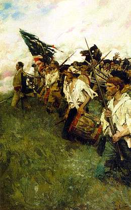
The creek lends its name to the 1777 Battle of Brandywine of the American Revolutionary War. General William Howe, commanding the British forces, was marching north on Baltimore Pike (now U.S. Route 1) toward Philadelphia and needed to ford the Brandywine near Chadds Ford. General George Washington, massed most of his American forces on the banks of the creek near Chadds Ford, and protected other fords as far as 5 miles (8.0 km) north and 3 miles (4.8 km) south. The Brandywine Battlefield Park covers only 50 acres (200,000 m2), but during the battle British troops marched about 6 miles (9.7 km) north, fording the creek above the forks, to outflank Washington's forces.[26] Before the battle, General Anthony Wayne had his headquarters in Brandywine Village, across the creek from Wilmington, and Continental troops camped nearby, near Lovering Avenue.[27]
Early paper mills were located along the creek, during the Revolution. They supplied Benjamin Franklin's print shop and also supplied the paper to print Continental currency and the Declaration of Independence.[12]
The Conestoga wagon was first built to haul grain from the Conestoga Valley to Brandywine flour mills.[28]
A group of painters, including N.C. Wyeth, Andrew Wyeth, Jamie Wyeth and Howard Pyle, are referred to as the "Brandywine School" especially for their landscape works which depict the Brandywine valley. Many of their works are on view at the Brandywine River Museum in Chadds Ford.[29][30]
Brandywine Village and early industrialization

The Brandywine crosses the fall line just north of Wilmington. The elevation falls from about 160 feet (49 m) above sea level in Chadds Ford, to just a few feet above sea level in Wilmington. The steep descent powered many early industrial activities, including flour milling and the original DuPont gunpowder mills, while the navigable channel to the Delaware River and Delaware Bay allowed manufacturers to load ocean-going ships from near their mills.
By 1687, a Swedish colonist, Tyman Stidham opened the first mill on the Brandywine, near Wilmington. About 1735, Brandywine Village was founded across the creek from Wilmington. Quakers Elizabeth Levis Shipley, her husband William Shipley,[32] and Thomas Canby were important in establishing the village and its supporting flour mills. By 1743, a dam and a millrace south of the creek had been built.

In 1760, a bridge was built at the current site of the Market Street Bridge, and the north race and two more flour mills were built by Joseph Tatnall.
Oliver Evans in the 1780s helped local mills increase their efficiency, ushering in the industrial revolution.[33]
The first paper mill in Delaware, Gilpin's mill in north Wilmington, opened in 1787. This site was later used by one of the largest textile mills in the world, Bancroft Mills, which is now closed.[34]
In 1796, the village contained 12 mills that could grind 400,000 bushels of grain per year.
By 1806, there were "about fifty or sixty snug brick, stone, and frame houses" in the village.[35]

In 1795, Jacob Broom built the first cotton mill on the Brandywine, a few miles north of the village, but it burned down two years later.[34] In 1802, Broom sold the site, complete with a working dam and millrace, to Eleuthère Irénée du Pont, who paid $6,740 for the 95 acres (380,000 m2).[36] Gunpowder mills, known as the Eleutherian Mills, operated on the site from 1802, and by 1810, the site was the largest gunpowder producer in the country. During the Civil War alone, over 4 million barrels of gunpowder were produced here. The mills, which operated until 1921, are now part of the Hagley Museum and Library.[37] The creek is located at the midpoint of the DuPont Historic Corridor.
By 1815, several toll roads connected the village with Pennsylvania's grain-growing regions, including the Lancaster, Kennett and Concord Pikes.[27] These roads later became Delaware Route 41, Delaware Route 52, and parts of US 202 combined with Delaware Route 202.

The millers cooperated in maintaining quality and branding the flour. "Brandywine Superfine" flour was shipped all along the Atlantic coast and to the West Indies before the American Revolution.
A mill race once used to provide water power is still in working condition in Brandywine Park, designed in the 1890s by Frederick Law Olmsted, near downtown Wilmington.
To the north, Downingtown on the east branch was originally known as Milltown. Its first building, the Downingtown Log House, was built about 1700 where the road between Philadelphia and Lancaster, later known as the Lancaster Pike, crossed the east branch. Thomas Moore built a grist mill in 1716 and Roger Hunt built another in 1739, which operated through at least 1908. Both the Downingtown Log House and the Roger Hunt Mill still stand today.[38]
Milltown was the halfway point on the journey between Philadelphia and Lancaster, so several inns served travelers, including the Ship Inn (c. 1730), the King-in-Armes or Washington Inn (1761), the Half-Way House (1790), and the Swan Hotel (1800).[38]
In the 1880s, Downingtown became known for its paper mills.[39]
Coatesville on the west branch became famous for producing iron goods as early as 1810, and later, rolling steel plate.[40] Lukens Steel Company has dominated the economy of the town since 1810; today, Mittal continues to make steel there.
Historic preservation
These places near the Brandywine are on the National Register of Historic Places.[41]
 About 1905, looking downstream toward Van Buren Street Bridge, Wilmington. Note the mill race on the right.
 Brandywine Creek in Wilmington in 2006
 William Lea house in Brandywine Village
 Brandywine Village from the Market Street Bridge from a postcard dated 1906.
 Market Street Bridge, looking downstream, with Brandywine Village on the left, and the Wilmington Pumping Station on the right. The bridge marks the approximate high level of tidewater on the Brandywine.
 DuPont gunpowder mills on the Brandywine, on a postcard dated 1905. These mills were still working at the time. Note the handwritten "These blow up occasionally, and then?"
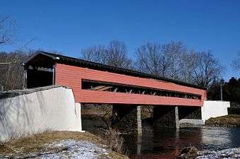 Smith's Covered Bridge
See also

- Bancroft Mills
- Brandywine Battlefield Park
- Brandywine Valley Railroad
- Chaddsford Winery
- East Branch Brandywine Creek
- Eleutherian Mills
- Forks of the Brandywine Presbyterian Church
- Longwood Gardens
- Nemours Mansion and Gardens
- Preston Lea
- Rockland, Delaware
- William Lea
- West Branch Brandywine Creek
- Wilmington State Parks
- List of Delaware rivers
- List of rivers of Pennsylvania
References
- ↑ U.S. Geological Survey Geographic Names Information System: Brandywine Creek (Christina River)
- ↑ United States Geological Survey Hydrological Unit Code: 02-04-02-05- Brandywine-Christina Watershed
- 1 2 U.S. Geological Survey. National Hydrography Dataset high-resolution flowline data. The National Map Archived 2012-04-05 at WebCite, accessed April 1, 2011
- ↑ USGS Station [01480700] & [01480870]
- ↑ USGS Station [01480300], [01480500] & [01480617]
- ↑ [01481000] (USGS Station
- ↑ [01481500] USGS Station
- ↑ USGS Station [01478120] & [01478245]
- ↑ [01479820 USGS Station
- ↑ [01482800] USGS Station
- ↑ "The Estuary". The Delaware Riverkeeper. Archived from the original on August 3, 2008. Retrieved November 18, 2008.
- 1 2 3 4 "History of the Brandywine Valley". Thebrandywine.com. Retrieved 2007-04-29.
- 1 2 "Native Americans, Introduction to the Lenni Lenape, or Delaware Indians". Penn Treaty Museum.org. Retrieved January 15, 2009.
- 1 2 "Lenni Lenape Native Americans". lchaddsfordhistory.org. Retrieved January 15, 2009.
- 1 2 "A Brief History of New Sweden in America". Swedish Colonial Society. Retrieved January 15, 2009.
- ↑ "A Map of the South and East Bounds of Pennsylvania in America Being partly inhabited". 1681. Retrieved January 15, 2009.
- ↑ Cramer, Harold. "Placing Pennsylvania on the Map: The Seventeenth Century". Articles on Historical Maps of Pennsylvania. MapsofPA.com.
- ↑ "RG-17, RECORDS OF THE LAND OFFICE,Series Descriptions". Records of Pre-Penn Settlement. Pennsylvania Historical and Museum Commission, Bureau of Archives and History, Pennsylvania State Archives. Retrieved January 15, 2009.
- ↑ Smith, George (1862). History of Delaware County, Pennsylvania. Media, PA: H.B. Ashmead. pp. 231–240. ISBN 1-55613-282-4.
- ↑ "History of Kennett Township". Kennett Township, Chester County, Pennsylvania. Archived from the original on March 10, 2009. Retrieved January 15, 2009.
- ↑ "Indian Hannah (1730–1802)". Historical Markers. ExplorePAhistory.com. Retrieved January 15, 2009.
- ↑ "'Nation Makers', by Howard Pyle" (mp3). Brandywine River Museum Audio Tours. Brandywine River Museum. Retrieved January 10, 2009.
- ↑ "Quaker Meetingsin Southern Chester County, PA and New Castle County, DE". localquakers.org. Retrieved January 15, 2009.
- ↑ Danson, Edwin (2001). Drawing the Line: How Mason and Dixon Surveyed the Most Famous Border in America. John Wiley and Sons. ISBN 0-471-43704-2.
- ↑ Ecenbarger, William (2000). Walkin' the Line: A Journey from Past to Present Along the Mason-Dixon. M.Evans. pp. 120–122. ISBN 0-87131-910-1.
- ↑ "History of the Battle of the Brandywine". Brandywine Battle Historic Site. USHistory.org. Retrieved January 10, 2009.
- 1 2 "Greater Brandywine Village". 1730–1820 Milling, the Revolutionary War and Industrial Innovation. Retrieved 2007-10-21.
- ↑ "About the Brandywine Valley". TheBrandywine.com. Retrieved January 15, 2009.
- ↑ "Chadds Ford History". Archived from the original on 2007-09-28. Retrieved 2007-10-21.
- ↑ Mummert, Roger (November 3, 2006). "Brandywine, a Valley of History, Nature and Art". New York Times. Retrieved January 10, 2009.
- ↑ Evans, Oliver (1848). The Young Mill-wright and Miller's Guide. Lea & Blanchard. p. 392.
- ↑ Milford, Maureen (August 27, 2000). "WHAT'S DOING IN; Brandywine Valley". New York Times. Retrieved November 18, 2008.
- ↑ Gies, Joseph (Fall 1990). "The Genius of Oliver Evans". American Heritage. Retrieved January 8, 2009.
- 1 2 Delaware Federal Writers' Project (1991) [1938]. Delaware: A Guide to the First State. Scholarly Press. p. 562. ISBN 978-0-403-02160-4.
- ↑ "Description of Wilmington". The Literary magazine, and American register. John Conrad & Co: 180–181. 1806.
- ↑ Kinnane, Adrian (2002). DuPont: From the Banks of the Brandywine to Miracles of Science. Wilmington: E.I. du Pont de Nemours and Company. ISBN 0-8018-7059-3
- ↑ Greenwood, Richard (January 26, 1979). "Eleutherian Mills" (PDF). National Register of Historic Places Inventory — Nomination Form. National Park Service. Retrieved January 10, 2009.
- 1 2 "History Of Downingtown". Downingtown Historical Society. Archived from the original on January 25, 2009. Retrieved January 16, 2009.
- ↑ Pennypacker, Charles H. (1909). History of Downingtown, Chester County, Pa. Downingtown Publishing Co. pp. 144–146.
- ↑ John Thomas, Faris (1919). Seeing Pennsylvania. J.B. Lippincott company. p. 347.
- ↑ National Park Service (2010-07-09). "National Register Information System". National Register of Historic Places. National Park Service.
- ↑ "Fort Christina". National Historic Landmarks Program. National Park Service. Retrieved November 17, 2008.
- ↑ "Holy Trinity Church (Old Swedes)". National Historic Landmarks Program. National Park Service. Retrieved November 17, 2008.
- ↑ "Howard High School". National Historic Landmarks Program. National Park Service. Retrieved November 18, 2008.
- ↑ "DELAWARE — New Castle County — Historic Districts". Retrieved November 17, 2008.
- 1 2 "DELAWARE — New Castle County — Historic Districts". Retrieved January 7, 2009.
- ↑ "Brandywine Park" (PDF). NATIONAL REGISTER OF HISTORIC PLACES INVENTORY-NOMINATION FORM. Delaware State Parks. Retrieved November 17, 2008.
- ↑ "Old First Presbyterian Church of Wilmington" (PDF). NATIONAL REGISTER OF HISTORIC PLACES INVENTORY-NOMINATION FORM. Delaware State Parks. Archived from the original (PDF) on February 3, 2007. Retrieved November 17, 2008.
- ↑ "Continental Army Encampment Site" (PDF). NATIONAL REGISTER OF HISTORIC PLACES INVENTORY-NOMINATION FORM. Delaware State Parks. Archived from the original (PDF) on April 12, 2007. Retrieved November 17, 2008.
- ↑ "Bancroft Mills" (PDF). NATIONAL REGISTER OF HISTORIC PLACES INVENTORY-NOMINATION FORM. Delaware State Parks. Retrieved November 17, 2008.
- ↑ "Rockford Park" (PDF). NATIONAL REGISTER OF HISTORIC PLACES INVENTORY-NOMINATION FORM. Delaware State Parks. Retrieved November 17, 2008.
- ↑ "Eleutherian Mills". National Historic Landmarks Program. National Park Service. Retrieved November 17, 2008.
- ↑ "PENNSYLVANIA — Delaware County". Retrieved January 20, 2009.
- ↑ "PENNSYLVANIA — Delaware County". Retrieved November 17, 2008.
- ↑ "Brandywine Battlefield". National Historic Landmarks Program. National Park Service. Archived from the original on March 14, 2004. Retrieved November 17, 2008.
- ↑ "Brinton's Mill" (PDF). ARCH: Pennsylvania's Historic Architecture and Archaeology. Commonwealth of Pennsylvania. Retrieved November 17, 2008.
- ↑ "Lenape Bridge" (PDF). ARCH: Pennsylvania's Historic Architecture and Archaeology. Commonwealth of Pennsylvania. Retrieved January 10, 2009.
- ↑ "Gibson's Covered Bridge" (PDF). ARCH: Pennsylvania's Historic Architecture and Archaeology. Commonwealth of Pennsylvania. Retrieved January 10, 2009.
- ↑ "Downingtown Log House" (PDF). ARCH: Pennsylvania's Historic Architecture and Archaeology. Commonwealth of Pennsylvania. Retrieved November 17, 2008.
- ↑ "Roger Hunt Mill" (PDF). ARCH: Pennsylvania's Historic Architecture and Archaeology. Commonwealth of Pennsylvania. Retrieved January 7, 2009.
- ↑ "Embreeville Historic District" (PDF). ARCH: Pennsylvania's Historic Architecture and Archaeology. Commonwealth of Pennsylvania. Retrieved January 14, 2009.
- ↑ "Coatesville Historical District" (PDF). ARCH: Pennsylvania's Historic Architecture and Archaeology. Commonwealth of Pennsylvania. Retrieved November 17, 2008.
- ↑ "Search form". ARCH: Pennsylvania's Historic Architecture and Archaeology. Commonwealth of Pennsylvania. Archived from the original on April 2, 2009. Retrieved January 7, 2009.
Further reading
- Bryant, Wiliam Cullen (1872). Picturesque America, Scenes on the Brandywine. New York: D. Appleton and Co. pp. 220–231.
- Henry Seidel Canby (1941). The Brandywine, illustrated by Andrew Wyeth, Schiffer Publishing, Atglen, PA. ISBN 0-916838-06-4
- MacElree, Wilmer (1912). Down the eastern and up the Black Brandywine. West Chester, PA: F.S.Hickman.
- Maynard, W. Barksdale. The Brandywine: An Intimate Portrait (University of Pennsylvania Press; 2014) 253 pages; Traces the history of the Delaware and Pennsylvania region around the Brandywine River since first European settlement.
- Bruce Mowday. (2001). Along the Brandywine River, Postcard History Series. Arcadia Publishing.
- Badertscher, Vera Marie, "Brandywine Valley, Pennsylvania and Delaware", in National Geographic Traveler. Accessed 2010-02-18
External links
| Wikimedia Commons has media related to Brandywine Creek (Christina River). |
| Library resources about Brandywine River |
- U.S. Geological Survey: PA Continuous Streamflow Gaging Stations
- Brandywine Conservancy
- Brandywine School (art review)
- Brandywine Valley Association
- Chadds Ford History
- 11 LIFE Photographs by Walker Evans of the DuPont gunpowder mills, 1957
- Pennsylvania Scenic Rivers website
- The Historic Christina Basin
- Historic images of the Brandywine from the Hagley Digital Archives
- Delaware's Industrial Brandywine
Dover (capital) | ||
| Topics |
|  |
| Society |
| |
| Cities | ||
| Towns |
| |
| Counties | ||