The Wiggle
Coordinates: 37°46′18″N 122°26′01″W / 37.77164°N 122.43357°W

The Wiggle is a one-mile, zig-zagging bicycle route from Market Street to Golden Gate Park in San Francisco, California, that minimizes hilly inclines for bicycle riders. Rising 120 feet (37 m), The Wiggle inclines average 3% and never exceed 6%. The path generally follows the historical route of the long since paved-over Sans Souci Valley watercourse, winding through the Lower Haight neighborhood toward the Panhandle section of Golden Gate Park.[1]

The lower end of the route begins at either end of the Duboce Bikeway in the block of Duboce Avenue just west of Market Street. The elevation is approximately 100 feet (30 m) above sea level. It then moves in a zig-zag toward the northwest along Duboce Avenue, Steiner, Waller, Pierce, Haight, Scott, and Fell Streets to the Panhandle Bikeway, 215 feet (66 m) above sea level. After climbing 50 more feet, the peak of The Wiggle is reached near Stanyan Street at the peninsular drainage divide, i.e., the dividing point between surface water flowing to the San Francisco Bay on the east side and flowing to the Pacific Ocean on the west.[2]
Bicyclists can travel The Wiggle between major eastern and central neighborhoods (such as Downtown, SoMa, The Mission District, The Castro) and major western neighborhoods (including the Panhandle, The Haight, Golden Gate Park,[3] and The Richmond and Sunset Districts).
History
Mint Hill and the hill of Alamo Square on the northeast side are made of underlying serpentine rock, whereas Lone Mountain, Corona Heights, and Buena Vista Hill on the southwest are of the Franciscan chert formation. These hills are the northernmost manifestation of the San Miguel Hills (including Twin Peaks), which themselves comprise the northern tip of the Santa Cruz Mountains.[4]
Over thousands of years, the gentle valley bottom was formed through a process of gradual erosion of the soft, crumbly serpentine. This flat creek bed contained, until roads and other construction obliterated them, the intermittent stream of the creek itself and two ponds. As with all such flat valleys, the location of ponds tended to shift, but they were generally located at what is now Divisadero Street near Oak Street and at Market Street from Belcher Street to Reservoir Street.
Human history
Before Europeans settled in San Francisco, a route approximately following that now known as "The Wiggle" was used as a way to avoid hills while walking. An Indian village called Chutchui existed in the vicinity of Mission Dolores near the area where The Wiggle meets Market Street. The foot path went toward what is now the Panhandle and then connected to the associated village Petlenuc at the northern tip of the San Francisco Peninsula near the current site of Crissy Field.[5]
When the San Francisco Presidio and the Mission Dolores were founded in 1776, the trail became a horseback connector eventually called "the Old Spanish Trail." In the 19th century, the trail was the commute route of military personnel who lived in the Mission District and worked at the Presidio. In the 1860s, it finally was widened to become a toll road, passable by carriages, and going by the name "Divisadero" or "Devisadero" Street. In the 1870s, a grid of streets was imposed in its place, one retaining the old road's name, across a newly formed neighborhood with all the sandy hills and steep gullies filled or scraped flat.[5]
In late 2012 final approval was secured and construction began on the Fell and Oak Street Bikeways, which when completed will add three blocks of one-way cycle track on both Fell and Oak Streets from Scott Street to the eastern end of the Panhandle at Baker Street, connecting the Wiggle to the Panhandle. Fell Street previously had a narrow bicycle lane wedged in between parked cars and fast-moving vehicular traffic, while Oak Street had no bicycle facilities at all. The project, which also includes pedestrian safety improvements such as sidewalk extensions and bulbouts, will be accomplished by removing all parking from the south side of both streets. Construction is expected to be complete by spring 2013.[6][7]
The route
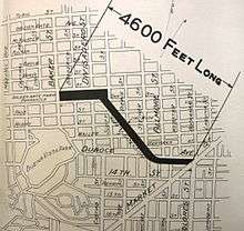
The Wiggle follows Duboce Avenue westbound, Steiner Street northbound, Waller Street westbound, Pierce Street northbound, Haight Street westbound, Scott Street northbound, and Fell Street westbound. The route always makes a turn toward the north or west each time the forward direction presents a hill steeper than the turn. Thus, starting at Market Street, this path avoids all steep areas and creates a route to the bike path in the Panhandle of Golden Gate Park, leading to the main routes through the Park itself. Similar "wiggles" can be found using this method for reading the geography in other hill areas.
Signage
San Francisco Bike Route 30 follows The Wiggle, with signs from Duboce Avenue westbound (at Market Street or Church Street). In some places, the signs also read "The Wiggle."[8] In 2011, sharrows were painted on top of green pavement marking the route, making navigation easier for cyclists and alerting drivers to the presence of cyclists.
References
- ↑ In 1994 Tubular Times (1994) printed an article on The Wiggle
- ↑ Map of The Wiggle (with terrain and elevation contour lines at 40-foot intervals) in Google Maps
- ↑ MapMyRide charted popular route to the De Young Museum of Art in Golden Gate Park from near Market Street
- ↑ Flora of the Santa Cruz Mountains of California: A Manual of the Vascular Plants by John Hunter Thomas, page 3
- 1 2 San Francisco's Thoroughfares by Edward A. Morphy, pages 473-5
- ↑ Lekach, Sasha (16 October 2012). "SFMTA Approves Plan To Slow Traffic Along Fell And Oak Streets". SF Appeal. Retrieved 13 December 2012.
- ↑ Bialick, Aaron (17 October 2012). "SFMTA Board Approves Fell and Oak Bikeways, Work to Begin This Month". Streetsblog San Francisco. Retrieved 13 December 2012.
- ↑ Map of all official San Francisco bike routes with grades and other data (PDF)