Buena Vista Park
| Buena Vista Park | |
|---|---|
|
The view from Buena Vista Park | |
 | |
| Type | Municipal (San Francisco) |
| Location | San Francisco |
| Coordinates | 37°46′06″N 122°26′27″W / 37.7683°N 122.4408°WCoordinates: 37°46′06″N 122°26′27″W / 37.7683°N 122.4408°W |
| Area | 37 acres (15 ha) |
| Created | 1867 |
| Open | All year |
| Official website | |

Buena Vista Park is a park in the Haight-Ashbury and Buena Vista Heights neighborhoods of San Francisco, California. It is the oldest official park in San Francisco, established in 1867 as Hill Park, later renamed Buena Vista. It is bounded by Haight Street to the north, and by Buena Vista Avenue West and Buena Vista Avenue East. The park is on a steep hill that peaks at 575 feet (175 m), and covers 37 acres (150,000 m2). The lowest section is the north end along Haight.
Layout
The hill on which the park lies is composed primarily of sand and San Francisco chert, formed in the Mesozoic era. The layout of the park uses the steepness of the hill to good advantage, offering good views of the city (particularly to the north).
At the peak of the park is a small lawn. Notable views are available from various lookouts lower down, including "The Window," an overlook on the western side of the hill from which there is a sweeping vista of Golden Gate Park, the Pacific Ocean, and, on clear days, northward up the coast to the white cliffs of Drake's Bay.
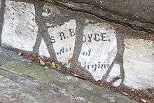
The paths along the west side are lined with gutters built by WPA workers out of broken headstones from the City's Victorian cemeteries at Lone Mountain (i.e. Laurel Heights), which were moved to Colma in 1930s.[1] In a few cases the inscriptions were placed facing up and can be discerned (Cf. the Wave Organ).
The northeast corner staircase features a large peace symbol (the classic Campaign for Nuclear Disarmament variety) shaped out of flower plantings. Further south a tennis court is located just inside the park at the intersection of Duboce and Buena Vista East streets.
Other points of interest
Across the street from the south side of the park is 355 Buena Vista East, an architecturally notable building which appears briefly in Alfred Hitchcock's Vertigo. The building, constructed in 1928 as St. Joseph's Hospital, has been converted to condominiums. The building is on the National Register of Historic Places.
The west side of the park near Frederick Street features a particularly noteworthy example of the modern-architecture work of Cass Calder Smith, as featured in many architectural magazines including Dwell. This modern house is no more, as it has been significantly modified with an addition of another level in 2015.
Transportation
Muni bus lines 6, 7, 43, 71, and 71L pass Buena Vista park on its north end along Haight St. The 37 line passes along the south end of the park. The 24 and 33 come within three blocks. The N Judah runs underneath the park via the Sunset Tunnel.
See also
References
- ↑ Details of the dismantlement of the Lone Mountain cemeteries in the Encyclopedia of San Francisco.
External links
- Official page on San Francisco Recreation and Parks web site