Taconic and West Avenues Historic District
|
Taconic and West Avenues Historic District | |
|
First Church of Christ Scientist | |
  | |
| Location | Great Barrington, Massachusetts |
|---|---|
| Coordinates | 42°11′27″N 73°22′5″W / 42.19083°N 73.36806°WCoordinates: 42°11′27″N 73°22′5″W / 42.19083°N 73.36806°W |
| Architect | Allen, Daniel; et al. |
| Architectural style | Georgian, Early Republic, Mid 19th Century Revival |
| NRHP Reference # | [1] |
| Added to NRHP | June 11, 1998 |
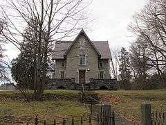
The Taconic and West Avenues Historic District is a largely residential historic district south of the downtown area of Great Barrington, Massachusetts. The roughly 117-acre (47 ha) district includes 172 contributing elements, most of which are houses or related buildings. Two thirds of the buildings were built between 1890 and 1910, and most of the rest were constructed in a historically sympathetic way.[2]
The southwestern corner of the district is the intersection of Maple and West Avenues. Its western boundary is a high wodded ridge that roughly parallels Castle Street, and follows Main Street and Maple Avenue on its eastern and southern boundaries. The housing in the district was built by Great Barrington's wealthier residents, and feature large houses built in a variety of popular styles of the period.[2] The district features Georgian, Early Republic, and Mid 19th-Century Revival architecture. It was added to the National Register of Historic Places in 1998.[1]
See also
- Great Barrington Station
- National Register of Historic Places listings in Berkshire County, Massachusetts
References
- 1 2 National Park Service (2008-04-15). "National Register Information System". National Register of Historic Places. National Park Service.
- 1 2 "NRHP nomination for Taconic and West Avenues Historic District". Commonwealth of Massachusetts. Retrieved 2013-12-04.
| Topics |  | ||||||||||||||||||||||||||||||
|---|---|---|---|---|---|---|---|---|---|---|---|---|---|---|---|---|---|---|---|---|---|---|---|---|---|---|---|---|---|---|---|
| Lists by county | |||||||||||||||||||||||||||||||
| Lists by city |
| ||||||||||||||||||||||||||||||
| Other lists | |||||||||||||||||||||||||||||||
| |||||||||||||||||||||||||||||||