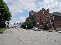
Summit Hill, Pennsylvania
| Summit Hill, Pennsylvania | |
|---|---|
| Borough | |
 | |
| Motto: "Where it all began" | |
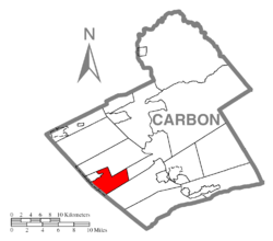 Location of Summit Hill in Carbon County | |
 Summit Hill, Pennsylvania Location of Summit Hill in Pennsylvania | |
| Coordinates: 40°49′39″N 75°51′57″W / 40.82750°N 75.86583°WCoordinates: 40°49′39″N 75°51′57″W / 40.82750°N 75.86583°W | |
| Country | United States |
| County | Carbon |
| Government | |
| • Mayor | Paul McArdle |
| Area | |
| • Total | 9.1 sq mi (24 km2) |
| • Water | 0.4 sq mi (1 km2) |
| Elevation | 1,510 ft (460 m) |
| Population (2010) | |
| • Total | 3,034 |
| • Density | 330/sq mi (130/km2) |
| Time zone | EST (UTC-5) |
| • Summer (DST) | EDT (UTC-4) |
| ZIP code | 18250 |
| Area code(s) | 570 Exchange: 645 |
| Website |
www |
Summit Hill is a borough in Carbon County, Pennsylvania, United States. The population was 3,034 at the 2010 census.[1] The hamlet has a storied history as the western terminus of the United States' second operational railway, the Mauch Chunk & Summit Hill Railway, and some of the earliest coal mines developed in North America, where the Lehigh Coal Mining Company began mining in 1792, establishing the town as little more than a mining camp with stables and paddocks.
History
Anthracite coal was discovered on the ridgeline of Sharpe Mountain[2] (now known as Pisgah Mountain[3]) in 1791 by a hunter,[2] and news of the find led to the founding of the Lehigh Coal Mining Company in 1792 which began exploring the area in earnest and buying up promising land. Coal was found in 1794 by Phillip Ginter[4] along the northeast-to-southwest-running ridgeline of Pisgah Mountain lying several hundred feet below the ridge on the north slope in an area that became the boroughs of Summit Hill and Lansford.
The Summit Hill High School was added to the National Register of Historic Places in 2001.[5]
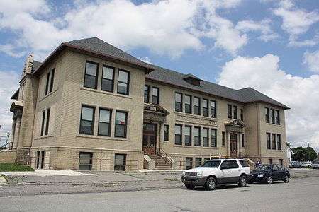 Summit Hill High School (1911)
Geography
Summit Hill is located in western Carbon County at 40°49′39″N 75°51′57″W / 40.82750°N 75.86583°W (40.827420, -75.865892).[6] The main development of the borough is on the crest of Pisgah Mountain, but the borough limits extend north to the ridgecrest of Nesquehoning Mountain, south to the far side of Mauch Chunk Ridge, and east to cover most of Mauch Chunk Lake. Also on the northern border is the borough of Lansford, while Tamaqua in Schuylkill County is on the western border.
According to the United States Census Bureau, Summit Hill borough has a total area of 9.1 square miles (23.6 km2), of which 8.7 square miles (22.5 km2) is land and 0.42 square miles (1.1 km2), or 4.54%, is water.[1] Summit Hill is located 6 miles (10 km) southwest of Jim Thorpe and 1 mile south of Lansford. Summit Hill's elevation varies from 1,520 feet (460 m) above sea level in the borough center to 1,620 feet (490 m) at the highest point on Pisgah Mountain to 1,010 feet (310 m) at Mauch Chunk Lake.
Demographics
| Historical population | |||
|---|---|---|---|
| Census | Pop. | %± | |
| 1890 | 2,816 | — | |
| 1900 | 2,986 | 6.0% | |
| 1910 | 4,209 | 41.0% | |
| 1920 | 5,499 | 30.6% | |
| 1930 | 5,567 | 1.2% | |
| 1940 | 5,406 | −2.9% | |
| 1950 | 4,924 | −8.9% | |
| 1960 | 4,386 | −10.9% | |
| 1970 | 3,811 | −13.1% | |
| 1980 | 3,418 | −10.3% | |
| 1990 | 3,332 | −2.5% | |
| 2000 | 2,974 | −10.7% | |
| 2010 | 3,034 | 2.0% | |
| Est. 2015 | 2,952 | [7] | −2.7% |
| Sources:[8][9][10] | |||
As of the census[9] of 2000, there were 2,974 people, 1,291 households, and 844 families residing in the borough. The population density was 333.7 people per square mile (128.9/km²). There were 1,451 housing units at an average density of 162.8 per square mile (62.9/km²). The racial makeup of the borough was 98.99% White, 0.07% African American, 0.10% Native American, 0.17% Asian, 0.07% from other races, and 0.61% from two or more races. Hispanic or Latino of any race were 0.40% of the population.
There were 1,291 households, out of which 25.3% had children under the age of 18 living with them, 50.1% were married couples living together, 10.6% had a female householder with no husband present, and 34.6% were non-families. 31.4% of all households were made up of individuals, and 18.5% had someone living alone who was 65 years of age or older. The average household size was 2.30 and the average family size was 2.86.
In the borough the population was spread out, with 20.1% under the age of 18, 6.9% from 18 to 24, 27.6% from 25 to 44, 23.4% from 45 to 64, and 22.1% who were 65 years of age or older. The median age was 42 years. For every 100 females there were 92.7 males. For every 100 females age 18 and over, there were 89.9 males.
The median income for a household in the borough was $37,287, and the median income for a family was $44,500. Males had a median income of $36,627 versus $23,507 for females. The per capita income for the borough was $21,166. About 4.0% of families and 7.5% of the population were below the poverty line, including 8.4% of those under age 18 and 6.2% of those age 65 or over.
Summit Hill is part of the Panther Valley School District, along with the neighboring towns of Lansford, Nesquehoning and Coaldale (Coaldale is located in Schuylkill County).
Notable people
- Colonel Thomas F. Breslin, World War II Bataan Death March prisoner
- Keith McCall, former Speaker of the Pennsylvania House of Representatives
- Samuel McLean, congressman
References
- 1 2 "Geographic Identifiers: 2010 Demographic Profile Data (G001): Summit Hill borough, Pennsylvania". U.S. Census Bureau, American Factfinder. Retrieved April 3, 2015.
- 1 2 Lee Mantz. "The Early Days of Summit Hill". Retrieved 9 September 2013.
In 1791 a hunter, Philip Ginter, discovered coal on Sharpe Mountain.
- ↑ U.S. Geological Survey Geographic Names Information System: Pisgah Mountain
- ↑ The Early Days of Summit Hill, accessed: 7 September 2013
- ↑ National Park Service (2009-03-13). "National Register Information System". National Register of Historic Places. National Park Service.
- ↑ "US Gazetteer files: 2010, 2000, and 1990". United States Census Bureau. 2011-02-12. Retrieved 2011-04-23.
- ↑ "Annual Estimates of the Resident Population for Incorporated Places: April 1, 2010 to July 1, 2015". Retrieved July 2, 2016.
- ↑ "Census of Population and Housing". U.S. Census Bureau. Retrieved 11 December 2013.
- 1 2 "American FactFinder". United States Census Bureau. Retrieved 2008-01-31.
- ↑ "Incorporated Places and Minor Civil Divisions Datasets: Subcounty Resident Population Estimates: April 1, 2010 to July 1, 2012". Population Estimates. U.S. Census Bureau. Retrieved 11 December 2013.
External links
| Wikimedia Commons has media related to Summit Hill, Pennsylvania. |
Municipalities and communities of Carbon County, Pennsylvania, United States | ||
|---|---|---|
| Boroughs | 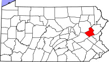 | |
| Townships | ||
| CDPs | ||
| Unincorporated communities | ||
| Footnotes | ‡This populated place also has portions in an adjacent county or counties | |