Lansford, Pennsylvania
| Borough of Lansford | |
| Settlement | |
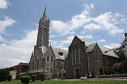 St. Katharine Drexel Church in the borough's historic district | |
| Country | United States |
|---|---|
| State | Pennsylvania |
| County | Carbon |
| District | Panther Creek Valley |
| Center | Panther Creek Valley, Southern Coal Region |
| - elevation | 1,145 ft (349.0 m) |
| - coordinates | 40°49′53″N 75°53′0″W / 40.83139°N 75.88333°WCoordinates: 40°49′53″N 75°53′0″W / 40.83139°N 75.88333°W |
| Area | 1.6 sq mi (4.1 km2) |
| - land | 1.6 sq mi (4 km2) |
| - water | 0.0 sq mi (0 km2), 0% |
| Population | 3,941 (2010) |
| Density | 2,710.0/sq mi (1,046.3/km2) |
| Borough (Pennsylvania) | ca. 1827 along with Coaldale, Schuylkill County, PA |
| Timezone | EST (UTC-5) |
| - summer (DST) | EDT (UTC-4) |
| ZIP Code | 18232 |
| US | 570 Exchange: 645 |
 Location of Lansford in Carbon County
| |
 Location of Lansford in Pennsylvania
| |
 Location of Pennsylvania in the United States
| |
Lansford is a county-border borough (town) in Carbon County, Pennsylvania, located 37 miles (60 km) northwest of Allentown and 19 miles south of Hazleton in the Panther Creek Valley about 72 miles (116 km) from Greater Philadelphia[lower-alpha 1] and abutting the cross-county sister-city of Coaldale in Schuylkill County. The whole valley was owned and subdivided into separate lots by the historically important Lehigh Coal & Navigation Company (locally called 'the Old Company') which likely settled some structures on the lands by 1827.[lower-alpha 2]

Lansford grew with the development of local anthracite coal mines, and was named after Asa Lansford Foster, who was an advocate for merging the small "patch towns" that developed in the area surrounding the anthracite coal mines. The population was 3,941 at the 2010 Census, a steep decline from a high of 9,632 at the 1930 census common to many mining towns in northeastern Pennsylvania.[2]
History
Lansford's first school was opened in 1847 on Abbott Street. Lansford's first church, the Welsh Congregational was built in 1850 and still stands today on West Abbott Street.
The old No. 9 Mine and Museum in Lansford, a deep mine which operated from 1855 to 1972, is now open as a tourist attraction offering tours of the mine and a wealth of information on local mining history. A museum occupying the mine's former Wash Shanty building on the site displays a large collection of mining artifacts. One of the local mine bosses, John P. Jones, was murdered in Lansford, reportedly in connection with labor union strife, attributed to members of a secret society known as the Molly Maguires, many of whom were put on trial and hanged in Carbon and Schuylkill Counties during the mid- to late 1870s.
Lansford was also the home of the first Commercial Cable Television system in the United States.
The Lansford Historic District was added to the National Register of Historic Places in 2012.[3]
Geography
According to the United States Census Bureau, the borough has a total area of 1.6 square miles (4.1 km2), all of it land. The town shares the border of Carbon and Schuylkill County with the abutting neighboring community of Coaldale, which is de facto, a suburban bedroom neighborhood. Lansford is 1 mile north of Summit Hill (the initial Anthracite deposits mined by the Lehigh Coal Company in 1780s.), and 10 miles west of Lehighton and 6 miles northeast of Tamaqua. Lansford's elevation is 1145 feet above sea level. It is also 5 miles northeast of Tamaqua, 27 miles northwest of Allentown, and 9 miles south of Hazleton. It is located on the northwestern fringe of the Lehigh Valley, and is at the southern end of the Coal Region and the Poconos.
Lansford sits on the north slope of Pisgah Mountain above and along the south bank of the Panther Creek tributary of the Little Schuylkill River athwart US-209 west of Jim Thorpe, Nesquehoning and the eastern extent of the Lehigh-Schuylkill drainage divide, down slope and below historic Summit Hill and east of abutting Coaldale and Tamaqua, Pennsylvania, both farther downstream and west. Nesquehoning Mountain dominates the north bank across the Panther Creek, and the rich coal mines of the valley shipped coal through the 3,800 feet (1,158.2 m) long Hauto Tunnel of the Central Railroad of New Jersey (CNJ) competing for the rich trade with New York City and Philadelphia.
Government
James Romankow is the Mayor of Lansford and is assisted by a council. The town also has a fire department and a police force.
Lansford is part of the Panther Valley School District and home of their newly remodeled football stadium and walking track.
Demographics
| Historical population | |||
|---|---|---|---|
| Census | Pop. | %± | |
| 1880 | 2,206 | — | |
| 1890 | 4,004 | 81.5% | |
| 1900 | 4,888 | 22.1% | |
| 1910 | 8,321 | 70.2% | |
| 1920 | 9,625 | 15.7% | |
| 1930 | 9,632 | 0.1% | |
| 1940 | 8,710 | −9.6% | |
| 1950 | 7,486 | −14.1% | |
| 1960 | 5,958 | −20.4% | |
| 1970 | 5,168 | −13.3% | |
| 1980 | 4,466 | −13.6% | |
| 1990 | 4,583 | 2.6% | |
| 2000 | 4,230 | −7.7% | |
| 2010 | 3,941 | −6.8% | |
| Est. 2015 | 3,798 | [4] | −3.6% |
| Sources:[5][6][7] | |||
As of the census[6] of 2000, there were 4,230 people, 1,878 households, and 1,098 families residing in the borough. The population density was 2,710.0 people per square mile (1,046.9/km²). There were 2,228 housing units at an average density of 1,427.4 per square mile (551.4/km²). The racial makeup of the borough was 98.18% White, 0.35% African American, 0.07% Native American, 0.31% Asian, 0.07% Pacific Islander, 0.28% from other races, and 0.73% from two or more races. Hispanic or Latino of any race were 1.42% of the population.
There were 1,878 households, out of which 24.6% had children under the age of 18 living with them, 38.4% were married couples living together, 14.9% had a female householder with no husband present, and 41.5% were non-families. 37.7% of all households were made up of individuals, and 23.4% had someone living alone who was 65 years of age or older. The average household size was 2.23 and the average family size was 2.92.
In the borough the population was spread out, with 22.5% under the age of 18, 7.3% from 18 to 24, 25.6% from 25 to 44, 19.1% from 45 to 64, and 25.5% who were 65 years of age or older. The median age was 41 years. For every 100 females there were 84.1 males. For every 100 females age 18 and over, there were 80.2 males.
The median income for a household in the borough was $27,478, and the median income for a family was $37,773. Males had a median income of $30,405 versus $22,255 for females. The per capita income for the borough was $14,347. About 10.9% of families and 14.3% of the population were below the poverty line, including 20.5% of those under age 18 and 10.4% of those age 65 or over.
Media
WLSH is a locally-owned 5,000-watt station at 1410 on the AM dial which signed-on December 24, 1952. The call letters stand for Lansford and neighboring Summit Hill.
Notes
- ↑ As the crow flys, and Google Map's ruler tool measures from the Liberty Bell to the point where Rt.209 enters Coaldale from Lansford. Further, the historic trip, by simple math, meant coal traveled Summit Hill and Mauch Chunk Railroad for 9 miles to the Lehigh Canal, then 45 miles of Canal to Easton, then 60 more on the Delaware Canal to its Bristol, PA. terminus.
- ↑ Geographically, Coaldale and Lansford are joined at the hip, geologically and geographically the same terrain. Coaldale was settled in 1827, when John Moser and his wife settled there.[1]
References
- ↑ David Kuchta citing Joseph Henry Zerbey (12 March 1934). "The History of Coaldale, PA. (1827)". History of Pottsville and Schuylkill County.
- ↑ Marsh, Ben (1987). "Continuity and Decline in the Anthracite Towns of Pennsylvania" (PDF). Annals of the Association of American Geographers. 77 (3): 337–352. doi:10.1111/j.1467-8306.1987.tb00163.x. Retrieved 1 January 2014.
- ↑ "National Register of Historic Places Listings". Weekly List of Actions Taken on Properties: 9/04/12 through 9/07/12. National Park Service. 2012-09-14.
- ↑ "Annual Estimates of the Resident Population for Incorporated Places: April 1, 2010 to July 1, 2015". Retrieved July 2, 2016.
- ↑ "Census of Population and Housing". U.S. Census Bureau. Retrieved 11 December 2013.
- 1 2 "American FactFinder". United States Census Bureau. Retrieved 2008-01-31.
- ↑ "Incorporated Places and Minor Civil Divisions Datasets: Subcounty Resident Population Estimates: April 1, 2010 to July 1, 2012". Population Estimates. U.S. Census Bureau. Retrieved 11 December 2013.
External links
| Wikimedia Commons has media related to Lansford, Pennsylvania. |
-
 "Lansford". Collier's New Encyclopedia. 1921.
Municipalities and communities of Carbon County, Pennsylvania, United States | ||
|---|---|---|
| Boroughs | 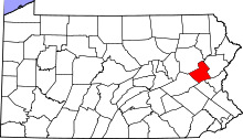 | |
| Townships | ||
| CDPs | ||
| Unincorporated communities | ||
| Footnotes | ‡This populated place also has portions in an adjacent county or counties | |