Strand, Western Cape
| Strand | |
|---|---|
|
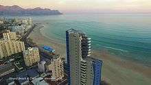
An aerial view of Strand with the Coast Road and Strand Golf Club in the foreground. | |
 Strand  Strand  Strand
| |
|
Location within Cape Town  Strand | |
| Coordinates: 34°07′00″S 18°49′00″E / 34.11667°S 18.81667°ECoordinates: 34°07′00″S 18°49′00″E / 34.11667°S 18.81667°E | |
| Country | South Africa |
| Province | Western Cape |
| Municipality | City of Cape Town |
| Established | 1714 |
| Area[1] | |
| • Total | 21.36 km2 (8.25 sq mi) |
| Population (2011)[1] | |
| • Total | 55,558 |
| • Density | 2,600/km2 (6,700/sq mi) |
| Racial makeup (2011)[1] | |
| • Black African | 11.6% |
| • Coloured | 51.1% |
| • Indian/Asian | 1.0% |
| • White | 34.2% |
| • Other | 2.1% |
| First languages (2011)[1] | |
| • Afrikaans | 77.2% |
| • English | 14.3% |
| • Xhosa | 2.2% |
| • Other | 6.3% |
| Postal code (street) | 7140 |
| PO box | 7139 |
| Area code | +27 (0)21 |

Strand (Afrikaans for 'beach') is a seaside resort situated on the eastern edge of False Bay and at the foot of the Hottentots Holland Mountains. Its geographical position is between Macassar and Gordon's Bay, and is about 50 km southeast of Cape Town. Strand is in the Western Cape province of South Africa, and has a population of approximately 50,000.[2] Strand's main attraction is the beach; 5 km of white sandy beach off False Bay.
Strand is often referred to as The Strand (Afrikaans: Die Strand), which is the old name of the town.
History
Strand was established as a holiday and fishing resort in 1714.[3] In 1970, during the notorious Apartheid era, all black, coloured and Asian people were forcefully removed when the town was classified as a white-only resort. Included in the communities forced to leave at this time were the descendants of Cape Malay slaves, who had escaped from Cape Town over 100 years earlier.[4] They lost their homes, but their mosque still stands today.
Strand falls under the City of Cape Town municipality. It is in close proximity to the inland town of Somerset West. Recent expansion and development of both towns has resulted in the two now being adjacent to each other, with shopping malls and residential complexes creating the connections. The unofficial divide between the two towns is the national road which bisects them, the N2. Strand forms part of the Helderberg Basin, along with Somerset West and Gordon's Bay.
Strand offers white-sanded beaches and views of the Cape Peninsula. During the summer, tourists from other parts of South Africa, including Johannesburg, and abroad, come to enjoy the seaside offerings. Tourism has been a major source of local income since 1950, when the town was popular with visitors from the north of the country, and was home to many retired veterans of the Boer War. There is a train service from Strand to the CBD of Cape Town. The great coastal road that makes its way up the eastern seaboard of the Cape rises to the coastal ranges from near Strand.
Strand also used to accommodate one of the largest dynamite factories in South Africa, owned by the AECI group. This area is being redeveloped into a large new mixed-use urban development, Paardevlei and current tenants include Cheetah Outreach.
Tourism
The main beach in the Strand, Melkbaai Beach, is known as one of the best and safest bathing areas in the country. Facilities on or nearby this beach include Waterworld with a super tube and mini-golf and Harmony Park which includes a tidal pool. Water sports may be conducted from various points along the beachfront.
Strand has a wide variety of organised sport including a golf course, tennis courts, rugby fields, squash clubs, jukskei, and water sports like surfing, sailing, power boating, paddle skiing and board sailing. The Pipe is a part of the beach marked off for surfers and is known for its big, "surfable" waves.
Strand also has an Olympic-sized indoor pool which is centrally heated and is open all year round. The coast between the Lourens River mouth and up to Rooi Els is popular with beach fishermen and rock anglers.
Surfing


Surfing is a popular water sport in Strand, despite the possibility of sharks. These spots are reportedly much easier and safer to surf than other offshore surf spots on the Atlantic Ocean side of the Cape Peninsula, owing to the protection that False Bay offers.
Central Business District
The town has a business district attracting customers from the surrounding basin. The CBD offers banks, numerous shopping malls, restaurants, and supermarkets. The Friedman & Cohen is the largest single shop in the CBD and serves as a major attraction for residents and visitors. The major shopping malls in the area include the Dorpsmeent Centre, Somerset Mall. The latter is not in the CBD, but outside the town, on the border of Somerset West.
Strand's central business district is entirely surrounded by Strand North and Strand South. Strand Beach Road is divided into three sections - the Golden Mile (also known as Melkbaai) is located between Lourens River and Hibernian Towers (cnr/o Beach Road and Sarel Cilliers Road), the central part of Beach Road stretches between Sarel Cilliers Road and the Pavilion complex, whilst the Platinum Mile is located along Blakes Beach and between Odeon Towers and the Ocean View Hotel.
Industrialism
Strand has its own industrial area, Gants Centre. More recently, Gants Centre has increasingly been accommodating non-industrial businesses, including the local newspaper, the District Mail / Distrikspos. These industrial companies are in turn gradually relocating to the areas surrounding the former dynamite sites outside the town, towards Somerset West.
In winter there is a low inversion layer covering the town, resulting in some degree of pollution. This is rarely seen, however, because of the prevalent winds that keep Strand's skies clean.
Education
The town has primary, secondary and tertiary education facilities, and many ECD facilities of varying quality. As of 2007, there are 19 public and private schools.
Primary schools
- Dr. G.J. Joubert
- Hendrik Louw Primary School
- Laerskool Lochnerhof
- Loreto Primary School (Strand)
- Strand Muslim Primary School**
High schools
- False Bay High School
- Hoërskool Strand
- Hottentots-Holland
- Khanyolwethu Sekondêr
- Madrasatyr Rajaa Sekondêr
- Rusthof Sekondêr
- Simanyene Sekondêr
- Strand Sekondêr
- Hoërskool Valsbaai
- Mills Street Art School
- Liams school of hard knocks
Tertiary institutions
- Boland College
List of suburbs
- Gordons Bay
- Harbour Island
- Lwandle
- Chris Nissen Park
- Lourensrivier
- Melkbaai
- Strand-Noord
- Suider Strand
- Mostert's Bay
- Strandvale
- Goedehoop
- Twin Palms
- Die Bos
Coats of arms
The Strand was a municipality from 1897 to 1996. During that period, it used two coats of arms.
Municipal (1) — The first coat of arms was assumed on 24 February 1927.[5] The shield was divided in two by a vertical line, and displayed a golden sun on a blue background, and a fish on a background of wavy silver and blue stripes; across the top of the shield was a golden stripe bearing three red towers. An anchor was placed behind the shield. The motto was Inspirata floruit.
Municipal (2) — In March 1955, the council approved a new version of the arms, by Ivan Mitford-Barberton. It registered them with the Cape Provincial Administration in August 1955[6] and at the Bureau of Heraldry in October 1993.[7]
The new shield of arms was : Per fess, Azure and barry wavy Argent and Azure, on a fess Gules, between in chief a demi-sun issuant and in base a fish naiant, three towers, Or. In layman's terms, the shield was now divided into three horizontal bands, displaying (1) a golden demi-sun on a blue background, (2) three gold towers on a red background, and (3) a golden fish on a background of wavy silver and blue stripes. A crest consisting of a red anchor on a golden mural crown was added. The motto remained the same.
Notes
- 1 2 3 4 "Main Place Strand". Census 2011.
- ↑ "Strand". Southern Africa Places. Retrieved 2006-10-15.
- ↑ "Strand". Southern Africa Places. Retrieved 2006-10-10.
- ↑ "SA History". South African History Online. Retrieved 2007-01-01.
- ↑ Western Cape Archives : Strand Municipal Minutes (24 February 1927).
- ↑ Cape of Good Hope Official Gazette 2771 (19 August 1955).
- ↑ http://www.national.archsrch.gov.za
External links
| Wikimedia Commons has media related to Strand, Western Cape. |
- The Strand Website
- Photo of busy Strand beach
- History, information and pictures
- The District Mail, regional newspaper
.svg.png)