Blue Downs
| Blue Downs | |
|---|---|
|
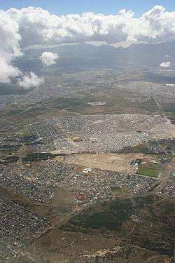
An aerial photograph of Blue Downs in the foreground and Mfuleni laying just beyond. Picture is taken of these two areas stretching to the west towards Table Mountain. Ikweze Park (on the left) and Delft (to the right) lay beyond. | |
 Blue Downs  Blue Downs  Blue Downs
| |
|
Location within Cape Town  Blue Downs | |
| Coordinates: 34°0′0″S 18°41′51″E / 34.00000°S 18.69750°ECoordinates: 34°0′0″S 18°41′51″E / 34.00000°S 18.69750°E | |
| Country | South Africa |
| Province | Western Cape |
| Municipality | City of Cape Town |
| Government | |
| • Type | Metropolitan City Council |
| • Councillor |
Cynthia Claasen (Ward 19) (DA) Bert Van Dalen (Ward 14) (DA) |
| Area[1] | |
| • Total | 24.57 km2 (9.49 sq mi) |
| Population (2011)[1] | |
| • Total | 92,330 |
| • Density | 3,800/km2 (9,700/sq mi) |
| Racial makeup (2011)[1] | |
| • Black African | 22.9% |
| • Coloured | 74.9% |
| • Indian/Asian | 0.5% |
| • White | 0.3% |
| • Other | 1.3% |
| First languages (2011)[1] | |
| • Afrikaans | 63.6% |
| • Xhosa | 17.0% |
| • English | 15.8% |
| • Other | 3.5% |
| Postal code (street) | 7100 |
| PO box | 7105 |
| Area code | 021 |
Blue Downs is a suburb of the Cape Town, South Africa. It is part of the Oosterberg sub-region of the city and is located on the Cape Flats.
The suburb is one of the outlying areas of Cape Town that has been targeted by the Western Cape provincial government for development. Planned developments include improved public transportation for the area and the building of additional schools.
See also
References
- 1 2 3 4 "Main Place Blue Downs". Census 2011.
.svg.png)
This article is issued from Wikipedia - version of the 10/2/2016. The text is available under the Creative Commons Attribution/Share Alike but additional terms may apply for the media files.