Somerset West
| Somerset West Somerset-Wes | |
|---|---|
|
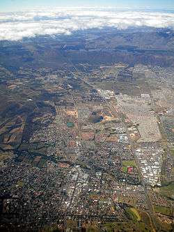
Aerial view of Somerset West with Hottentots-Holland Mountains and the Steenbras Dam in the background | |
 Somerset West  Somerset West  Somerset West
| |
|
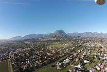
Location within Cape Town  Somerset West | |
| Coordinates: 34°05′S 18°51′E / 34.083°S 18.850°ECoordinates: 34°05′S 18°51′E / 34.083°S 18.850°E | |
| Country | South Africa |
| Province | Western Cape |
| Municipality | City of Cape Town |
| Established | 1822 |
| Government | |
| • Councillors | Benedicta van Minnen (Ward 15); Stuart Bruce Pringle (Ward 84) |
| Area[1] | |
| • Total | 61.37 km2 (23.70 sq mi) |
| Population (2011)[1] | |
| • Total | 55,166 |
| • Density | 900/km2 (2,300/sq mi) |
| Racial makeup (2011)[1] | |
| • Black African | 13.0% |
| • Coloured | 24.5% |
| • Indian/Asian | 0.9% |
| • White | 60.1% |
| • Other | 1.6% |
| First languages (2011)[1] | |
| • Afrikaans | 52.3% |
| • English | 37.5% |
| • Xhosa | 4.8% |
| • Other | 5.3% |
| Postal code (street) | 7130 |
| PO box | 7129 |
| Area code | +27 (0)21 |
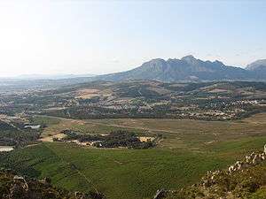
Somerset West (Afrikaans: Somerset-Wes) is a town in the Western Cape, South Africa. Organisationally and administratively it is included in the City of Cape Town metropolitan municipality. It is situated in the Helderberg area (formerly called Hottentots Holland), about 50 kilometres (30 mi) east of Cape Town central city area, and 10 kilometres (6 mi) from Strand. The town is overlooked by the Helderberg (meaning "clear mountain"), a part of the Hottentots-Holland range of mountains. The vehicle registration code for Somerset West is CFM and the post code is 7130 for street addresses, and 7129 for post office boxes.
History
A cattle post was established here by Dutch soldiers in 1672.
A town developed around the Lourens River (originally "Tweederivier", which means "Second River"; "Eersterivier", meaning "First River" passes through Stellenbosch, some 16 km to the north) and the farm of Vergelegen (Dutch: "remotely situated"), an 18th-century farmhouse built in the historic Cape Dutch style by Willem Adriaan van der Stel, governor of the Cape and son of Simon van der Stel, who gave his name to the nearby town of Stellenbosch. Willem Adriaan was later sent back to Holland after being charged with corruption and cruelty towards local Dutch farmers. The farm is now owned by a subsidiary of the large mining company Anglo American, who have restored the farmhouse to its original magnificence and continue to produce some of South Africa's best wines there. The farm is open to tourists.
Somerset West was founded in 1822 on part of the historic farm, Vergelegen.[2] The town was named Somerset after an English governor of the Cape Colony during the 1800s, Lord Charles Henry Somerset, with the suffix 'West' being added after 1825 to differentiate it from Somerset East, another South African town in the Eastern Cape. In the 1830s, Sir Lowry's Pass, named after later governor Sir Lowry Cole, was constructed to link the town with outposts further east over the Hottentots-Holland mountains.
In the 1960s, the AECI factory between Somerset West and Strand was the second largest dynamite factory in the world.
Local attractions
Somerset West lies in the Helderberg Basin, surrounded by an amphitheatre of mountains, between the Cape Winelands and False Bay. Every December, the town has a fairly decorative display of Christmas lights erected atop the street lights of the Main Road. The Helderberg Lights Festival (aka the Strawberry Festival), a flea market and parade, normally complements these lights.
The area also has its own community radio station, Radio Helderberg, broadcasting community notices and playing adult orientated pop music.
The Helderberg Nature Reserve, a 363 hectare natural wildlife preserve opened in 1964, contains a wide variety of smaller fauna (buck, tortoises and other reptiles) and outstanding specimens of indigenous flora such as protea and fynbos.
The Vergelegen Wine Estate lies just outside the town itself. The buildings on the estate constitute fine examples of Cape Dutch architecture.
The Lwandle Migrant Labour Museum is located in Lwandle Township and is dedicated to the history of Black migrant workers in the area during the apartheid era. It is one of only a few museums in South Africa that covers this aspect of the country's history.
Somerset West contains a number of sporting facilities including several golf courses.
The historic town of Stellenbosch is reachable via the R44 motorway (approx 18 km/11 mi away). The area between Somerset West and Stellenbosch also encompasses many vineyards and wineries (e.g. Rust-en-Vrede, Lourensford, Alto, J.P. Bredell) where visitors can sample and purchase wine. The oldest remaining vineyard in South Africa, Vergelegen, is situated on the outskirts of Somerset West.
In recent years many guest houses and B&Bs have opened up in Somerset West, since it is conveniently located for Cape Town (40 kilometres (25 mi) away on the N2 motorway), the beaches at the Strand and Gordon's Bay, as well as the Western Cape's numerous wine farms.
Education
The town has a range of primary and secondary educational facilities.
Primary schools
- Somerset West Primary School
- Somerset House
- Somerset College
- Somerset West Private School
- Helderberg Primary School
- De Hoop Primary
- Beaumont Primary
- International School of Helderberg
- Danie Ackerman Primary School
- Reddam House
- Newberry Montessori School
- Curro Primary School
High schools
- Hottentots Holland High School
- Parel Vallei High School
- Somerset College
- Somerset West Private School
- Somerset Private
- Helderberg High School
- International School of Helderberg
- Gordon High School
- Reddam House
Higher Education
List of suburbs
- Boskloof Eco Estate
- Bridgewater
- Briza
- Dennegeur
- Die Wingerd
- Erinvale
- Fernwood
- Garden Village
- Golden Acre
- Golden Hill
- Helderberg Estate
- Helderrand
- Heldervue
- Helderzicht
- Helena Heights
- Jacques Hill
- La Concorde
- La Sandra
- Land en Zeezicht
- Lwandle
- Montclair
- Monte Sereno
- Morningside
- Parel Vallei
- Rome Glen
- Roundhay
- Somerset Ridge
- Spanish Farm
- Steynsrust
- The Links
- Westridge
- World's View
- Olive Grove
Famous persons
- Penny Streeter OBE – business tycoon, millionaire
- Johann Rupert – business tycoon, billionaire
- Henry Vollam Morton – journalist and travel writer
- Selborne Boome – rugby union player
- Handre Pollard - rugby onion player
- Ramsay Carelse – high jumper
- Chris McGregor – jazz pianist, bandleader and composer
- Ernest "Eddie" Peirce – boxer
- Eddie Daniels (political activist) – ex-political prisoner on Robben Island
- Trevor Immelman – professional golfer and winner of the 2008 Masters Tournament.
- Heinz-Georg Wilhelm Migeod – German stuka pilot of WW2, author of four books and historian. He lived in South Africa from 1973 and died in Somerset West in 2010.
- Bob Walsh - Anne Walsh - Helen Dooley – former members of the British pop band "The Dooleys", credited with ten top 40 hits in the 1970s, now members of local band "Shiraz"
- Marius Schoeman – SA 7S rugby player
- Wouter Hugo Du Toit – rugby union player, entrepreneur
- Ricky Klopper – Community Leader and thinker
- Renier Palland – Afrikaans poet and international entertainment journalist
- Michael Burke – musician/leader
Coats of arms
Municipality (1) — Somerset West was a municipality in its own right from 1904 to 1996. The council approved its first coat of arms on 23 April 1935.[3]
Municipality (2) — In 1953, the council approved a new design, by Ivan Mitford-Barberton and H. Ellis Tomlinson. This was in response to a Cape Provincial Administration circular calling on municipalities to have their arms checked and, if necessary, re-designed to make them heraldically correct. The arms were granted by the College of Arms on 25 November 1953. They were registered at the Bureau of Heraldry in June 1994.[4]
The arms were: Azure, a portcullis chained Or; on a chief of the last a setting sun Gules (i.e. a blue shield displaying a red setting sun on a golden stripe across the top, and a golden portcullis with chains below it). The crest was a golden demi-lion holding a vine, issuing from a red mural crown charged with three golden rings. The motto was Prorsum sursum. The design is canting: the portcullis comes from the Somerset family arms, and the setting sun denotes the west.
References
- 1 2 3 4 "Main Place Somerset West". Census 2011.
- ↑ Sandra Olivier (2005). Touring in South Africa. Struik. p. 30. ISBN 978-1-77007-142-1. Retrieved 2013-09-20.
- ↑ Western Cape Archives : Somerset West Municipal Minutes (23 April 1935).
- ↑ National Archives of South Africa : Data of the Bureau of Heraldry
.svg.png)
| Wikivoyage has a travel guide for Somerset West. |