Texas State Highway 171
| ||||
|---|---|---|---|---|
 | ||||
| Route information | ||||
| Maintained by TxDOT | ||||
| Length: | 110.845 mi[1] (178.388 km) | |||
| Existed: | by 1933 – present | |||
| Major junctions | ||||
| South end: |
| |||
|
| ||||
| North end: |
| |||
| Highway system | ||||
| ||||

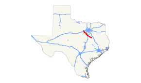
State Highway 171 is a southeast to northwest state route that starts by branching off U.S. Highway 84 in Mexia (southern end) and ends at an intersection with U.S. Highway 180 in Weatherford (northern end).
Route description
SH 171 begins at an intersection with US 84 in Mexia, before quickly intersecting State Highway 14. Leaving the town, SH 171 runs northwest to Tehuacana, before running in a more west direction to Coolidge. The highway runs in a northwest direction again, running through the towns of Hubbard and Malone before entering Hillsboro. SH 171 runs through the town overlapped with State Highway 22, before running in a mostly north direction towards Cleburne. In Cleburne, SH 171 shares an overlap with State Highway 174 through the city. After crossing US 67 and the Chisholm Trail Parkway, the highway turns back in a more northwest direction towards Godley and Cresson. After Cresson, SH 171 briefly has a run in Hood County before entering Parker County. The highway enters into Weatherfood, where it ends in downtown at an intersection with US 180.
History
The route was originally designated by 1933 along the portion between Hillsboro and Coolidge. By 1939, the route had been extended to the northwest significantly, absorbing portions of SH 2A and all of SH 122.
Junction list
| County | Location | mi | km | Destinations | Notes |
|---|---|---|---|---|---|
| Limestone | Mexia | ||||
| | |||||
| Tehuacana | |||||
| | |||||
| Coolidge | South end of FM 73 overlap | ||||
| | North end of FM 73 overlap | ||||
| Hill | Hubbard | ||||
| Malone | |||||
| Bynum | |||||
| | |||||
| | South end of SH 22 overlap | ||||
| Hillsboro | |||||
| South end of SH 81 overlap | |||||
| North end of SH 81 overlap | |||||
| North end of SH 22 overlap | |||||
| | |||||
| | South end of FM 934 overlap | ||||
| | North end of FM 934 overlap | ||||
| | |||||
| | |||||
| Covington | |||||
| Johnson | Parker | South end of FM 916 overlap | |||
| | North end of FM 916 overlap | ||||
| | |||||
| Cleburne | South end of SH 174 overlap | ||||
| South end of FM 4 overlap | |||||
| North end of FM 4 overlap | |||||
| North end of SH 174 overlap | |||||
| Connection via County Road 1125 | |||||
| Godley | South end of FM 2331 overlap | ||||
| Hood | Cresson | ||||
| | |||||
| Parker | | South end of FM 51 overlap | |||
| Weatherford | |||||
| North end of FM 51 overlap; continues past US 180 as FM 51 | |||||
1.000 mi = 1.609 km; 1.000 km = 0.621 mi
| |||||
See also
References
- ↑ Transportation Planning and Programming Division (n.d.). "State Highway No. 171". Highway Designation Files. Texas Department of Transportation. Retrieved 2008-03-13.