Texas State Highway 170
| ||||
|---|---|---|---|---|
| Alliance Gateway Freeway | ||||
 | ||||
| Route information | ||||
| Maintained by TxDOT | ||||
| Length: | 6.516 mi[1] (10.486 km) | |||
| Existed: | 1988[1] – present | |||
| Major junctions | ||||
| West end: |
| |||
|
| ||||
| East end: |
| |||
| Location | ||||
| Counties: | Tarrant, Denton | |||
| Highway system | ||||
| ||||

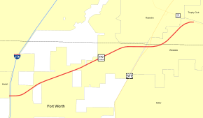
State Highway 170 (SH 170) also known as the Alliance Gateway Freeway, is a Texas state highway in the northern suburbs of Fort Worth. The highway was designated in 1988.
The North Texas Tollway Authority planned to build tolled main lanes by 2015 and will extend the highway west to US 287/US 81, and, eventually, ultimately to extend it to the Jacksboro Highway, but it didn't occur. (SH 199).[2]
History
SH 170 was originally designated by 1933 as a connector route from the Oklahoma border west to US 60 and US 87 near Canadian. This route was redesignated as SH 33 in 1955 to coincide with OK 33, with which it connects.[1]
Major intersections
| County | Location | mi[3] | km | Destinations | Notes |
|---|---|---|---|---|---|
| Tarrant | Fort Worth | Proposed western terminus | |||
| Blue Mound Road or Avondale-Haslet Road | Part of proposed tollway expansion, exit depends on routing of tollway | ||||
| Part of proposed tollway expansion | |||||
| Harmon Road | Part of proposed tollway expansion | ||||
| 0.0 | 0.0 | Current western terminus, exit 65 on I-35W | |||
| 0.8 | 1.3 | Old Denton Road | At-grade intersection, no interchange planned | ||
| 1.5 | 2.4 | North Beach Street | Future tolled interchange | ||
| 1.9 | 3.1 | Alta Vista Road | At-grade intersection, no interchange planned | ||
| 2.6 | 4.2 | Westport Parkway | Future tolled interchange | ||
| 3.1 | 5.0 | Park Vista Road | At-grade intersection, future tolled interchange (westbound only) | ||
| 3.1 | 5.0 | Park Vista Main Line Gantry (future toll plaza) | |||
| 3.9 | 6.3 | Independence Parkway | At-grade intersection, future tolled interchange | ||
| Westlake | 4.8 | 7.7 | At-grade intersection, future tolled interchange | ||
| 5.3 | 8.5 | Roanoke Road | At-grade intersection, future tolled interchange | ||
| Denton | 6.1 | 9.8 | J. T. Ottinger Road (future Dove Road) | At-grade intersection, future tolled interchange | |
| 6.6 | 10.6 | At-grade intersection, future grade-separated interchange | |||
1.000 mi = 1.609 km; 1.000 km = 0.621 mi
| |||||
References
- 1 2 3 Transportation Planning and Programming Division (n.d.). "State Highway No. 170". Highway Designation Files. Texas Department of Transportation. Retrieved March 25, 2012.
- ↑ Staff. "State Highway 170 Major study" (PDF). NTTA. Retrieved April 2, 2012.
- ↑ Google (September 22, 2013). "Overview Map of Texas State Highway 170 (Alliance Gateway)" (Map). Google Maps. Google. Retrieved September 22, 2013.
This article is issued from Wikipedia - version of the 9/7/2016. The text is available under the Creative Commons Attribution/Share Alike but additional terms may apply for the media files.