Springfield, Dane County, Wisconsin
- For other places named Springfield, see Springfield, Wisconsin.
| Springfield, Wisconsin | |
|---|---|
| Town | |
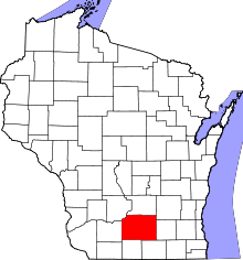
 Location in Dane County and the state of Wisconsin. | |
| Coordinates: 43°9′57″N 89°32′44″W / 43.16583°N 89.54556°WCoordinates: 43°9′57″N 89°32′44″W / 43.16583°N 89.54556°W | |
| Country | United States |
| State | Wisconsin |
| County | Dane |
| Area | |
| • Total | 36.4 sq mi (94.2 km2) |
| • Land | 36.2 sq mi (93.8 km2) |
| • Water | 0.2 sq mi (0.5 km2) |
| Elevation[1] | 1,056 ft (322 m) |
| Population (2000) | |
| • Total | 2,762 |
| • Density | 76.3/sq mi (29.5/km2) |
| Time zone | Central (CST) (UTC-6) |
| • Summer (DST) | CDT (UTC-5) |
| Area code(s) | 608 |
| FIPS code | 55-75875[2] |
| GNIS feature ID | 1584192[1] |
Springfield is a town in Dane County, Wisconsin, United States. The population was 2,762 at the 2000 census. The unincorporated communities of Ashton, Ashton Corners, Kingsley Corners, Martinsville, and Springfield Corners are located in Springfield.
Geography
According to the United States Census Bureau, the town has a total area of 36.4 square miles (94.2 km²), of which, 36.2 square miles (93.8 km²) of it is land and 0.2 square miles (0.5 km²) of it (0.49%) is water.
Demographics
As of the census[2] of 2000, there were 2,762 people, 967 households, and 770 families residing in the town. The population density was 76.3 people per square mile (29.5/km²). There were 993 housing units at an average density of 27.4 per square mile (10.6/km²). The racial makeup of the town was 97.68% White, 0.54% African American, 0.07% Native American, 0.54% Asian, 0.36% from other races, and 0.80% from two or more races. Hispanic or Latino of any race were 0.72% of the population.
There were 967 households out of which 41.2% had children under the age of 18 living with them, 72.7% were married couples living together, 3.8% had a female householder with no husband present, and 20.3% were non-families. 14.4% of all households were made up of individuals and 4.3% had someone living alone who was 65 years of age or older. The average household size was 2.86 and the average family size was 3.20.
In the town the population was spread out with 30.1% under the age of 18, 5.5% from 18 to 24, 28.3% from 25 to 44, 28.6% from 45 to 64, and 7.5% who were 65 years of age or older. The median age was 38 years. For every 100 females there were 105.4 males. For every 100 females age 18 and over, there were 109.1 males.
The median income for a household in the town was $68,663, and the median income for a family was $76,295. Males had a median income of $49,792 versus $31,674 for females. The per capita income for the town was $26,946. About 3.4% of families and 3.8% of the population were below the poverty line, including 3.0% of those under age 18 and 6.3% of those age 65 or over.
Notable people
- Bernard Esser, farmer, businessman, and politician, lived in the town.[3]
References
- 1 2 "US Board on Geographic Names". United States Geological Survey. 2007-10-25. Retrieved 2008-01-31.
- 1 2 "American FactFinder". United States Census Bureau. Retrieved 2008-01-31.
- ↑ 'Wisconsin Blue Book 1883,' Biographical Sketch of Bernard Esser, pg. 488
External links
| Surrounding communities |
|  | ||||||
|---|---|---|---|---|---|---|---|---|
| Counties | ||||||||