Oregon, Wisconsin
| Oregon, Wisconsin | |
|---|---|
| Village | |
|
South Main Street Historic District | |
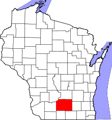
 Location in Dane County and the state of Wisconsin. | |
| Coordinates: 42°54′16″N 89°25′47″W / 42.90444°N 89.42972°WCoordinates: 42°54′16″N 89°25′47″W / 42.90444°N 89.42972°W | |
| Country | United States |
| State | Wisconsin |
| County | Dane |
| Government | |
| • Village President | Steve Staton |
| Area[1] | |
| • Total | 4.42 sq mi (11.45 km2) |
| • Land | 4.42 sq mi (11.45 km2) |
| • Water | 0 sq mi (0 km2) |
| Elevation[2] | 1,053 ft (321 m) |
| Population (2010)[3] | |
| • Total | 9,231 |
| • Estimate (2012[4]) | 9,561 |
| • Density | 2,088.5/sq mi (806.4/km2) |
| Time zone | Central (CST) (UTC-6) |
| • Summer (DST) | CDT (UTC-5) |
| ZIP code | 53575 |
| Area code(s) | 608 |
| FIPS code | 55-60225[5] |
| GNIS feature ID | 1583868[2] |
| Website | www.vil.oregon.wi.us |

Oregon is a village in Dane County, Wisconsin, United States. As of the census of 2010, the population was 9,231. Oregon is part of the Madison Metropolitan Statistical Area. The village is located mostly within the Town of Oregon.
History
Oregon was settled in 1841 by Bartlet Runey, and the first house was constructed in 1843.[6] Initially the settlement was known as "Rome Corners," and there is a road south of the village which still bears that name. When the Chicago and North Western Transportation Company came though the village in the 1864, their maps indicated a name of "Oregon," and the name was adopted.[7] The village was incorporated in 1881.
Many of Oregon's historical buildings still stand in the downtown district, including the Netherwood Block on the south, the Badger Cycle Company building and original water tower on the southeast on Janesville Street, and numerous business lining the west side of North and South Main Street. The Red Brick School, one of the more distinguishable structures in the village, built in 1922 as the high school, stands north of downtown. It was recently restored and now serves as the business offices for the Gorman Company.[8]
Geography
Oregon is located at 42°55′26″N 89°22′56″W / 42.92389°N 89.38222°W (42.923899, -89.382304).[9]
According to the United States Census Bureau, the village has a total area of 4.42 square miles (11.45 km2), all of it land.[1]
Oregon is served primarily by US-14 and Wisconsin Highway 138 and the two highways meet at the village's southeast corner. US-14 previously ran through the village, travelling down North Main Street and then arcing along Janesville Street, but a bypass was constructed from 1969-1973 along the North and East of the village. The previous route is now signed as County Trunk MM.
Demographics
| Historical population | |||
|---|---|---|---|
| Census | Pop. | %± | |
| 1880 | 527 | — | |
| 1890 | 595 | 12.9% | |
| 1900 | 697 | 17.1% | |
| 1910 | 712 | 2.2% | |
| 1920 | 871 | 22.3% | |
| 1930 | 857 | −1.6% | |
| 1940 | 1,005 | 17.3% | |
| 1950 | 1,341 | 33.4% | |
| 1960 | 1,701 | 26.8% | |
| 1970 | 2,553 | 50.1% | |
| 1980 | 3,876 | 51.8% | |
| 1990 | 4,519 | 16.6% | |
| 2000 | 7,514 | 66.3% | |
| 2010 | 9,231 | 22.9% | |
| Est. 2015 | 10,043 | [10] | 8.8% |
2010 census
As of the census[3] of 2010, there were 9,231 people, 3,589 households, and 2,527 families residing in the village. The population density was 2,088.5 inhabitants per square mile (806.4/km2). There were 3,775 housing units at an average density of 854.1 per square mile (329.8/km2). The racial makeup of the village was 95.4% White, 1.2% African American, 0.2% Native American, 0.8% Asian, 0.2% Pacific Islander, 0.8% from other races, and 1.5% from two or more races. Hispanic or Latino of any race were 2.2% of the population.
There were 3,589 households of which 40.8% had children under the age of 18 living with them, 55.6% were married couples living together, 10.3% had a female householder with no husband present, 4.5% had a male householder with no wife present, and 29.6% were non-families. 23.8% of all households were made up of individuals and 7.9% had someone living alone who was 65 years of age or older. The average household size was 2.55 and the average family size was 3.04.
The median age in the village was 37 years. 28.6% of residents were under the age of 18; 6.1% were between the ages of 18 and 24; 28.8% were from 25 to 44; 26.8% were from 45 to 64; and 9.6% were 65 years of age or older. The gender makeup of the village was 47.8% male and 52.2% female.
2000 census
As of the census[5] of 2000, there were 7,514 people, 2,796 households, and 2,071 families residing in the village. The population density was 2,451.2 people per square mile (945.0/km²). There were 2,895 housing units at an average density of 944.4 per square mile (364.1/km²). The racial makeup of the village was 97.71% White, 0.56% Black or African American, 0.19% Native American, 0.67% Asian, 0.19% from other races, and 0.69% from two or more races. 0.67% of the population were Hispanic or Latino of any race.
There were 2,796 households out of which 43.5% had children under the age of 18 living with them, 61.9% were married couples living together, 8.8% had a female householder with no husband present, and 25.9% were non-families. 20.4% of all households were made up of individuals and 7.3% had someone living alone who was 65 years of age or older. The average household size was 2.66 and the average family size was 3.10.
In the village the population was spread out with 30.5% under the age of 18, 5.9% from 18 to 24, 34.5% from 25 to 44, 20.3% from 45 to 64, and 8.7% who were 65 years of age or older. The median age was 34 years. For every 100 females there were 94.6 males. For every 100 females age 18 and over, there were 88.8 males.
The median income for a household in the village was $56,584, and the median income for a family was $65,518. Males had a median income of $43,015 versus $30,791 for females. The per capita income for the village was $23,650. About 1.8% of families and 3.3% of the population were below the poverty line, including 3.4% of those under age 18 and 10.0% of those age 65 or over.
Economy
As of 2011, Oregon's three largest employers were: Wisco Industries, Trachte Inc and Bill's Food Center.
Education
The Oregon School District serves the area. Schools in the district include Brooklyn Elementary, Netherwood Knoll Elementary, Prairie View Elementary, Rome Corners Intermediate, Oregon Middle School and Oregon High School.[12]
Oregon emergency services
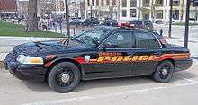
The Oregon Police Department and the Oregon Area Fire/EMS District serve the area.

Religion
- Deer Park Buddhist Center and Monastery is located in Oregon.
- Holy Mother of Consolation Parish
- First Presbyterian Church
- People's United Methodist Church
- St. John's Lutheran Church (ELCA)
- Faith Evangelical Lutheran Church
- Hillcrest Bible Church
- Community of Life
- Vineyard
Honors
In 2011, Oregon was named one of the "100 Best Small Places to Live" by CNN Money.[13]
Notable people
- Micah Alberti, actor and model
- Kevin J. Anderson, author
- Lyman F. Anderson, Wisconsin State Assemblyman[14]
- Wallace W. Andrew, Wisconsin State Assemblyman[15]
- Jerry Frei, former head coach of the Oregon Ducks and NFL assistant coach
- Christopher J. Rollis, newspaper editor and Wisconsin State Assemblyman
- Jeffrey B. Skiles, Miracle on the Hudson co-pilot
- Shaka Smart, head coach of University of Texas's men's basketball team
- Lisa Stone, former UW–Madison basketball coach
References
- 1 2 "US Gazetteer files 2010". United States Census Bureau. Archived from the original on January 24, 2012. Retrieved 2012-11-18.
- 1 2 "US Board on Geographic Names". United States Geological Survey. 2007-10-25. Retrieved 2008-01-31.
- 1 2 "American FactFinder". United States Census Bureau. Retrieved 2012-11-18.
- ↑ "Population Estimates". United States Census Bureau. Archived from the original on June 17, 2013. Retrieved 2013-06-24.
- 1 2 "American FactFinder". United States Census Bureau. Retrieved 2008-01-31.
- ↑ http://www.oregonareahistoricalsociety.org/oregon_history.htm
- ↑ http://www.oregonareahistoricalsociety.org/documents/articles/village_name.htm
- ↑ http://www.oregonareahistoricalsociety.org/gorman_award-9-08.htm
- ↑ "US Gazetteer files: 2010, 2000, and 1990". United States Census Bureau. 2011-02-12. Retrieved 2011-04-23.
- ↑ "Annual Estimates of the Resident Population for Incorporated Places: April 1, 2010 to July 1, 2015". Retrieved July 2, 2016.
- ↑ "Census of Population and Housing". Census.gov. Archived from the original on May 11, 2015. Retrieved June 4, 2015.
- ↑ "Oregon School District". Oregon School District. Retrieved 2012-06-18.
- ↑ "Best Places to Live Money's list of America's best small towns". CNN Money. Retrieved 14 September 2011.
- ↑ Lyman Anderson, Wisconsin Historical Society
- ↑ 'Wisconsin Blue Book 1905,' Biographical Sketch of Wallace W. Andrew, pg. 1096
External links
| Wikimedia Commons has media related to Oregon, Wisconsin. |
- Oregon, Wisconsin Chamber of Commerce
- Village of Oregon
- Oregon Public Library
- Oregon Area Historical Society
- Sanborn fire insurance maps: 1894 1899 1910
| Surrounding communities |
|  | ||||||
|---|---|---|---|---|---|---|---|---|
| Counties | ||||||||