South Mumbai
| South Mumbai (Old Bombay) दक्षिण मुंबई | |
|---|---|
| Precinct of Greater Mumbai | |
|
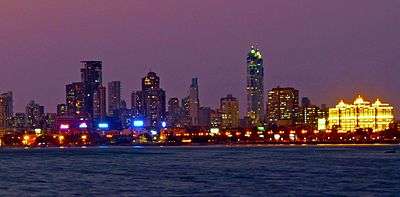
Night view of South Mumbai from the sea | |
 The South Mumbai precinct is shown in orange | |
| Coordinates (India Post Office GPO): 18°56′20″N 72°50′14″E / 18.9389245°N 72.8372392°E | |
| Country | India |
| State | Maharashtra |
| District | Mumbai City |
| Metro | Mumbai |
| Wards |
A, B, C, D, E, FS, FN, GS, GN |
| Area | |
| • Total | 67.7 km2 (26.1 sq mi) |
| Population (2011) | |
| • Total | 3,145,966 |
| • Density | 46,000/km2 (120,000/sq mi) |
| Time zone | IST (UTC+5:30) |
| South Mumbai: Population Growth | |||
|---|---|---|---|
| Census | Pop. | %± | |
| 1971 | 3,070,380 | — | |
| 1981 | 3,285,040 | 7.0% | |
| 1991 | 3,174,910 | -3.4% | |
| 2001 | 3,326,840 | 4.8% | |
| Est. 2011 | 3,145,966 | [1] | -5.4% |
| Source: MMRDA[2] Data is based on Government of India Census. | |||
.jpg)
South Mumbai (Marathi: दक्षिण मुंबई), or SoBo, is the southernmost precinct of the city of Mumbai, Maharashtra, India, comprises the city's main business localities and its adjoining areas. It is the richest urban precinct in India. Property prices in South Mumbai are the highest in India and are among the highest in the world. Notably Cumballa Hill, Malabar Hill, Breach Candy, Kemps Corner as well as some parts of Worli are constantly ranked in the Global Property Index. Billionaire Mukesh Ambani's $1.5 billion dollar home Antilia is located here and is now a part of the iconic skyline.
Most residents of SoBo belong to old money business, law, trade and fashion families. Living here for generations, many residents see no charm of shifting to Suburban Mumbai, even though its proximity to the airport & BKC is more convenient than that of the South. Film stars and their kin reside in the Suburbs, due to the film studios being located there.
Geographically, South Mumbai lies at the southern corner of Salsette Island. Most city residents use the term to refer to the stretch extending from Colaba to Mahim as South Mumbai. This delimitation is also known as Mumbai City or Island City. The area is delimited on the east by Mumbai harbour and on the west by the Arabian Sea. The areas from Bandra and beyond form a part of Suburban Mumbai. See also Mumbai City District. Most residents confuse Parel to be a part of the suburbs. Residents of this part of the island are known as SoBo-ites.
South Bombay is also home to the most prestigious schools; namely The Cathedral & John Connon School, JB Petit, Campion, Bombay International etc ; the most exclusive clubs: CCI, The Willingdon Sports Club as well as Bombay Gymkhana and the most expensive hospitals: Breach Candy Hospital, Jaslok and Hurkisondas Hospital; in the nation.
Significance
South Mumbai hosts the Reserve Bank of India and the Bombay Stock Exchange. Its primary business districts are the Fort, Nariman Point, Ballard Estate and more recently Lower Parel. Many leading Indian and multi-national companies are headquartered here. Chhatrapati Shivaji Terminus (CST) and Churchgate serve as headquarters and starting point for country's Central and Western Railway lines respectively.
In South Mumbai, unlike many parts of India, uninterrupted supply of power is available around the clock. A particular feature that distinguishes South Mumbai from the rest of Mumbai is the absence of autorickshaws. Only black and yellow taxis are permitted to ply in South Mumbai, along with private taxis more recently. The area houses a significant proportion of prime upmarket residential neighbourhoods of Mumbai including: Peddar Road, Nepean Sea Road, [Kemps Corner], Altamont Road, Carmichael Road, Breach Candy and Walkeshwar Road, forming a sort of golden quadrilateral and includes some of the most expensive residential areas in the world, such as the Hanging Gardens, Kemps Corner, Cuffe Parade and Malabar Hill. Lately there has been a surge of landmark real estate projects which have come in and around Lower Parel like Crescent Bay by L&T Realty, Mahalaxshmi, Prabhadevi, Lalbaug, Parel, Curry Road, Dadar, Matunga and Worli hence consolidating South Mumbai as one of the most prestigious and costliest places to live in India. Govt of Maharashtra has selected Parel for smart city initiative.
Many distinctive sporting clubs have been an integral part of South Mumbai landscape like the Willingdon Sports Club, the Turf Club at Mahalaxmi Racecourse, the Bombay Gymkhana, the Breach Candy Club, the N.S.C.I, and the Malabar Hill Club (Formerly W.I.A.A Club). The CCI and MCA are located at Mumbai's two cricket stadiums, Brabourne and Wankhede respectively.
Although land reclamation has allowed the southernmost tip of the district to double in size since the 1970s, the business districts face an acute shortage of real estate. As a result, the real-estate prices are among the top ten world-wide. As a ratio to average per capita income, real-estate prices in the business districts remain the most expensive in the world.
South Mumbai houses some of the best schools in the city as well as the nation, including Christ Church School, The Cathedral & John Connon, The Bombay International School, S.T. Mary's (I.S.C.), J.B. Petit, GD Somani, Villa Theresa, Bombay Scottish, Greenlawns High School and Campion School amongst others.
South Mumbai is also the home to several of the city's sporting grounds, including Brabourne Stadium, Wankhede Stadium, Cooperage Ground, Azad Maidan Oval Maidan and Shivaji Park.
Ethnically, south Mumbai continues to be dominated by the diverse communities of the ethnic population.
Division
The city of Mumbai lies on Salsette Island. Administratively it has two official divisions: Mumbai City district and Mumbai Suburban district. Mumbai City district consists of the southernmost part of Salsette Island - the area called South Mumbai. The western part of Mumbai Suburban district (to the west of Sanjay Gandhi National Park) is called the Western Suburbs and the eastern part of the district is called the Eastern Suburbs.
The northernmost portion of the island - outside Mumbai city limits - lies in Thane District.
South Mumbai, the Western suburbs, Navi Mumbai and the Eastern Suburbs are not official divisions of Mumbai and as such different people may include different areas in each division. This article uses the most popular divisions.
Old Bombay

Old Bombay was used to refer to the area which was formed by the merging of the seven original islands of Mumbai, India. The term was used from the 19th century until the 1980s, and is now considered archaic. The more widely used term today is simply the word 'town'.
When the islands were merged, the area became Old Bombay. The region north of this became Greater Bombay; now known as the 'Suburbs'. Greater Bombay encompasses an area 5 times the size of Old Bombay.
The region of Old Bombay consists of South Mumbai's city centre, which is the richest area in India and the nerve centre of Indian commerce.
See also
Notes
- ↑ "Mumbai's Population 2012". Archived from the original on 15 Jan 2013. Retrieved 28 June 2013.
- ↑ Population and Employment profile of Mumbai Metropolitan Region, p. 7
References
- "Population and Employment profile of Mumbai Metropolitan Region". Mumbai Metropolitan Region Development Authority (MMRDA). Archived from the original (PDF) on 28 December 2009. Retrieved 4 June 2010.
External links
| Wikivoyage has a travel guide for South Mumbai. |
| Pre-colonial | |
|---|---|
| Colonial | |
| Beaches | |
| Places of worship | |
| Cultural | |
| Boulevards | |
| Districts | |
| Shopping | |
| Buildings | |
| Parks, zoos and stadia | |
| Museums | |
| Forts | |
| Restaurants & Bars | |
Coordinates: 18°58′N 72°49′E / 18.96°N 72.82°E