Kurla
| Kurla कुर्ला | |
|---|---|
| Neighborhood | |
|
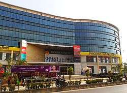
Phoenix Market city mall, opened in 2011 | |
 Kurla | |
| Coordinates: 19°04′N 72°53′E / 19.06°N 72.89°ECoordinates: 19°04′N 72°53′E / 19.06°N 72.89°E | |
| Country | India |
| State | Maharashtra |
| District | Mumbai Suburban |
| Metro | Mumbai |
| Languages | |
| • Official | Marathi |
| Time zone | IST (UTC+5:30) |
| PIN | 400070[1] |
| Area code(s) | 022 |
| Vehicle registration | MH 03 |
| Civic agency | BMC |
Kurla is a vast locality of Mumbai, India. It is the headquarters of the Kurla taluka of Mumbai Suburban District. It is named after the eponymous East Indian village that Kurla grew out of. It falls under Zone 5, Ward 'L' of the Municipal Corporation of Greater Mumbai. Its railway station, spelt as Coorla until 1890,[2] is one the busiest on the Mumbai suburban railway on the central and harbour railway lines of Mumbai as is the Lokmanya Tilak Terminus (LTT) for out-station passenger/express trains.
History
The locality gets its name from the East Indian village of Kurla, whose name in turn originated from "Kurli", the local name for crab, as these were found in plenty in marshes in the vicinity of the village. The village of Kurla came under Portuguese rule when the Treaty of Bassein (1534) was signed by Sultan Bahadur of Gujarat and the Kingdom of Portugal on 23 December 1534. In 1548, the village of Kurla and six other villages were given by the Governor of Portuguese India to Antonio Pessoa as a reward for his military services.[3] Kurla remained under Portuguese rule until the British occupied Salsette Island in 1774. The island was formally ceded to the East India Company in the 1782 Treaty of Salbai.
In 1805, Kurla was connected to Sion on Bombay Island by the Sion Causeway. Coorla, as it was spelt during the British Raj until 1890, was a major station on the Great Indian Peninsula Railway between Bombay and Thane, the first railway line in British India when it opened in 1853.
In 1808, Kurla, along with the villages of Mohili, Kolekalyan, Marol, Sahar, Asalphe, and Parjapur, were given by the British to a Parsi merchant of Bombay, Mr. Hormasji Bamanji Wadia in exchange for a piece of land near the Apollo pier gate in Bombay. His Son, Mr. Ardeshir Hormasji Wadia, after whom the A. H. Wadia Road was named, paid for them a yearly Quit-rent of £358 (Rs. 3587).
Kurla had two cotton mills, one of them, the Dharamsi Punjabhai, being the largest cotton spinning and weaving mill in the Bombay Presidency, with 92,094 spindles and 1280 looms. The other was the Kurla Spinning and Weaving Mill. Kurla village had a population of 9,715 at that time. About half of them worked in the mills, while the rest were fishermen, husbandmen (farmers) and salt-makers. The Holy Cross Church at Kurla, built during the Portuguese rule and rebuilt in 1848, is one of the oldest churches in Mumbai.[4]
The Mithibai Hormasji Wadia Dispensary was built by Mr. Bamanji Hormasji Wadia in 1855, and endowed by him with £1200 (Rs. 12,000). It was in charge of an assistant surgeon, and, in 1880–81, had an attendance of 7367 out-patients. The salt pans covered an area of about 66 acres (270,000 m2) and yielded a yearly revenue of £3418 (Rs. 34,180). There was also a considerable manufacture of shell lime. The Stone quarries of Kurla were well known[5] and supplied material for the construction of most of the city's famous heritage buildings[6] like the Prince of Wales Museum,[7] and the General Post Office[8] among others.
The beginning of the twentieth century saw Kurla develop as an important centre of the mill industry. In 1910, there were reported to be several mills in Kurla, engaged in the manufacturing of cotton cloth and woollen cloth in steam factories. Kurla, however, was an old textile industrial core, an outlier to the main cotton mill zone. A relatively cheaper land value and nearness to water and power mains enabled rapid industrial expansion of the suburbs and the Kurla-Ghatkopar-Vikhroli-Bhandup belt soon developed into the largest industrial zone in the suburbs of Mumbai.[9]
The Central Railway began its Harbour Line services from Kurla to Reay Road station on 12 December 1910. This service was extended to Victoria Terminus in 1925.[10] The Kurla Railway Car-shed was constructed in 1925 when electrification of the Great Indian Peninsula Railway (GIPR) Harbour line was undertaken. The first electric train in Asia that ran between CST and Coorla on February 3, 1925 was maintained at this car shed.[11] The Salsette-Trombay Railway, also known as the Central Salsette Tramway, opened in 1928. The 13 kilometre line, a project of the Bombay Improvement Trust run by the GIPR, ran from Trombay to Andheri via Kurla and lasted only a few years.[12]
During the late fifties and sixties, the old Kurla neighbourhood developed into an automobile industrial zone, with the erection of the Premier Automobiles main assembly plant in this area.[13] The Dairy Development Department of the State Government, in order to cope-up with the increasing demand for milk, established a dairy at Nehru nagar, Kurla (East) in 1975.[14]
Geography

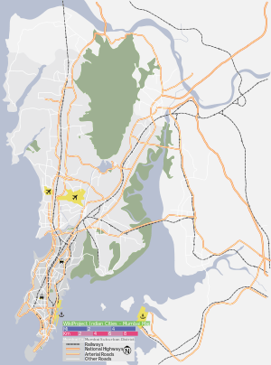
Kurla lies on the southern end of Salsette Island along the east bank of the Mithi River. Kurla may be divided into two parts: Kurla (East) and Kurla (West), separated by the Central Railway line. Kurla East is bordered by the suburban neighbourhoods of Chunabhatti in the south, Chembur in the East and Ghatkopar in the North. Kurla West is surrounded by Ghatkopar and Saki Naka neighbourhood of Andheri East to its North, Kalina and the Bandra Kurla Complex to its West and the Sion - Dharavi area to its south across the Mahim Creek. The Mithi River enters into Kurla's north- west corner near Sakinaka, running south along the Chhatrapati Shivaji International Airport boundary wall and the Bail Bazar locality, past the CST road and Taximen colony areas and empties into the Mahim Creek at the southern end of Kurla.
Administration
Kurla is the headquarters of the Kurla taluka of Mumbai Suburban District. The taluka was carved out of South Salsette Taluka in 1920. It covers an area of 135 square kilometres, covering a total of 29 villages in two circles. This taluka occupies the east side of the district and is bordered by the Bandra taluka in the West, the Sanjay Gandhi National Park to the northwest, the Thane District in the north, the Thane Creek to the east, and Mumbai City district to the south.[15]
The entire suburb falls under Zone 5, Ward 'L' of the Brihanmumbai Municipal Corporation. The Ward municipal offices are located in the Municipal market building on S. G.Barve Road. Residents of Kurla come under the Kurla (Vidhan Sabha constituency) (Number 174).[16] The number of electorates in 2009 was 284,951 (male 161,459, female 123,492).[17]
Localities
Kurla displays an urban blend of residential colonies, big and small, industrial estates commercial enclaves and slums. The L-Ward has the highest number of public open spaces subject to encroachment in the city with 80 of its 139 open spaces being encroached upon.[18]
Old Kurla

The earliest settlements in Kurla were in this area in the northern end of Kurla West. It consists of:
- the East Indian village of Kurla, popularly known as 'Christian Village', with the adjoining predominantly Christian 'Hall Village'.
- Wadia Estate, built on the property of the A. H. Wadia charity trust, located on A. H. Wadia Marg adjoining the Mithi River and the Chhatrapati Shivaji International Airport.
- Bail Bazaar and Sindhi Camp (populated by mostly Sindhis, Kanojias and Malwanis)
- Sambhaji Chowk, Sandesh Nagar, Sayog Nagar and Kranti Nagar slums on the banks of the Mithi River.
- Jarimari, Kajupada and Safed Pool areas on the Andheri Kurla road.
- Buddha Colony (where 3000 Buddhists are located)
The area has witnessed a construction boom in the early 21st century with the redevelopment of large former industrial plots. Kohinoor city and Phoenix Marketcity projects have been developed on land previously occupied by the Premier Automobiles and Mukand Engineering respectively.
New Kurla
The southern end of Kurla began developing with the arrival of the cotton mills and the railway line. Some prominent localities and landmarks are:
- Jai Bhawani Chowk, Jai Shankar Chowk and Subhash Nagar on New Mill Road. 90% of residents of Jai Shankar Chowk are from Kaikadi Samaj and work in the BMC and Air India.
- BMC colony near New Mill Road & H.P. Keluskar Road.
- LIG, MIG and HIG Colonies at Vinobha Bhave Nagar, which also has a police station by that name. The Santa Cruz – Chembur link road alignment passes through this area.
- K. B. Bhabha Hospital with its neighbourhoods of Chhadva Nagar and Murli Milan Society
- Kurla Bus Depot on Lal Bahadur Shastri Marg (LBS Road) with the adjoining areas of Taximen's colony, Kapadia Nagar and Kismat Nagar on CST road. This area enjoys close proximity to the Bandra Kurla Complex. The Peninsula Technopark stands on the site of the erstwhile Swan Mills.
- Kurla Railway Station area with the "Yadav Mandai" (fish, meat and vegetable market) and Brahminwadi on "Pipe Road" that runs along the water pipe line.
- Salafi Welfare Society near Halav Pool, Gol Building and Masrani Lane
- Indira Nagar, Parigh Khadi, and Kurla Garden are slum areas situated to the south of the Kurla Court.
Kurla East
Areas in Kurla East include:
- Nehru Nagar: The Government Dairy is located here. It has Mumbai's second biggest MSRTC bus depot.
- Shiv Shrusti: A residential colony near the bus depot
- Railway Colony: A residential colony near Lokmanya Tilak Terminus
- Kamgar Nagar: A residential area with row houses (now developed as bungalows)
- Hilphi House (House of a Portuguese Builder)
- Raza (quresh) Nagar: It has two major chowk known as Muftie azam chowk and Siraj Miya Road, very near to kurla Railway station east.
Transport
Kurla is accessible from all parts of Mumbai by road and rail due to its central location.
Roads
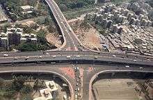
The Lal Bahadur Shastri Marg (formerly known as Old Agra Road) is the arterial road for Kurla West. The road begins at the southern end of Salsette Island, passing through Kurla and continuing up north into Ghatkopar towards Thane. The Andheri – Kurla road links Kurla with Andheri via Saki Naka, The road is notorious for its long traffic jams. while CST road (Central Salsette Tramway Road) leads to Santacruz. The Kurla Depot Junction is one of LBS marg's busiest junctions, with one arm proceeding towards the Western Express Highway and the other leading to the Santacruz-Chembur Link Road flyover.[19]
The 6.45 kilometre long Santa Cruz – Chembur link road was opened in April 2014. It connects the east and west sides of Kurla via a Road over bridge (ROB) over the Central railway line, which is also the city's first double-decker flyover[20] The road finally connects to the Eastern Express Highway at the Amar mahal junction. The Eastern Express Highway is the main thoroughfare for Kurla East. It runs from Sion Causeway in the south to Mulund in the North.
BEST buses travel from Kurla to all areas of Mumbai. The Kurla BEST Depot on the west suffered serious damage during the Mumbai floods of 2005 and has since been shut for redevelopment. Buses from this depot used to cater to Mumbai University (Kalina Campus), Bandra Kurla Complex and Chembur.[21] Maharashtra State Road Transport Corporation buses ply from their depot at Nehru Nagar in the East to major towns in the State. Auto rickshaws and taxis are also available.
Railways
Kurla railway station is a junction of the Central Railway Suburban line and the Harbour Line.
Lokmanya Tilak Terminus, formerly known as Kurla Terminus, is situated in the East. It was inaugurated in the 1980s and renovated in 2013.[22] The Terminus handles several Central Railway Zone outstation trains every day.
Education
Kurla has one engineering college, Don Bosco Institute of Technology, and several schools, including:-.
- Al-Barkat – English Medium
- Anjuman Islam Allana School and Junior College
- Anjuman Khairul Islam Urdu High School
- Anjuman Tabligul Islam Urdu High School
- Bharat Education Society's Vivek English High School (Kurla East)
- Darul-Uloom Ghausiya Ziaul Quran
- Eden Jr. College - Safed Pool
- Gandhi Bal Mandir High School – Marathi Medium
- Ganesh Baug [Marathi, Hindi & English Medium] Municipal School
- Green Bombay High School, Raza (quresh) Nagar.
- Green Bombay Urdu High School, Muftie azam chowk.
- Holy Cross High School
- Iqra International School
- K. M. S. P. Mandal's High School- Marathi Medium
- Karthika High School – English Medium
- Kedarnath Vidya Prasarini (KVP) – English High School
- Kohinoor Business Management
- Kohinoor International School
- M. E. S. Urdu High School
- Madrasa Darrul-Uloom Mehboob-E-Shobhani Arabic School
- Madrasa Salafia Arabic School
- Michael High School – English medium high school
- Mumbai Utkal English High School
- Nariman lane municipal urdu school
- Nehru Nagar Municipal School, Kurla – E
- Sant Gadge Maharaj Vidyala-Kurla W
- School of General Education Institute – Kurla High School (Marathi Medium)
- Shantaram Krishnaji Pantawalawalkar High School - Marathi and English (previously known as New English School)
- Shishu Vihar Kurla-W
- Shishu Vikas Mandir High School – Marathi Medium
- Shivaji Vidyalaya
- Shree Gujarati Samaj Vidhyalaya
- Siddiqui English High School Quresh Nagar
- St. Joseph's High School
- St. Jude's High School, Jarimari
- Swami Dayanand Vidyalaya High School
- Swami Vivekanand High School and College
- Urdu Municipal School, Muftie azam chowk; Raza Nagar.
Notable residents
- Balwinder Sandhu, Indian Test cricketer
- Candice Pinto, model and Miss Tourism International 2002[23]
- Erica Fernandes, model and actress
- Gurudas Kamat, politician and former member of parliament[24]
- Iqbal Abdulla, Indian cricketer, playing in Royal Challengers Bangalore
- Kamran Khan, cricketer, former Pune Warriors player[25]
- Navaneet Kaur, actress (former resident)
- Shaikh Shamim Ahmed, former MLA, Indian politician and Senior Congress leader
- Steven Dias, Indian football player (former resident)
Hospitals
Khan Bahaddur Bhabha Hospital
The Khan Bahaddur Bhabha Municipal General Hospital, on Belgrami Road, near Bharat Cinema, is one of Mumbai's 16 peripheral hospitals run by the Brihanmumbai Municipal Corporation. It has more than 300 beds and provides secondary-level referral health care services. The hospital started off in 1935 as a 30-bed maternity home called Khan Bahadur Hospital. An outpatient department (OPD) was added in 1950, converting it into a general hospital. Several other departments like surgery and pediatrics were added from 1962 on.[26]
Additionally, 'L' Ward has 9 municipal dispensaries, 12 municipal health posts and 67 privately run nursing homes and hospitals.[27]
- Arpan Nursing Home
- Aryan Hospital
- Central Hospital
- Fauziya Hospital
- Fehmida Nursing Home
- Habib Hospital
- Infy Eye Care
- Islahi Day Care
- Kohinoor City Hospital
- Kurla Nursing Home
- Masoom Children Nursing Home
- New Noor Hospital
- Sheetal Nursing Home
- Vcare Diagnostic
- City Hospital and Research Center
- Sindhu Maternity & Nursing Home
Places of worship
- Sarveshwar mandir Temple, S.M. Road, Takiya Ward
- Kedarnath Mandir, Nehru nagar, kurla East
- Ghausiya Ziaul Quran Masjid and Madarsa, A. Gafoor Khan Estate
- Masjid Ahle-Hadees, Fitwala Compound, CST Road
- Amrapali Buddha Vihar, S. G. Barve Road
- Balaji Mandir
- Gaondevi Mandir, Gaondevi Nagar, LIG colony
- Gazi Baba Dargah, Halav Pool
- Hanuman Mandir, Naupada
- Holy Cross Church, Premier Road
- Jagruti Vinayak Mandir
- Kristha Kanti Church, Hall Road
- Kurla Bene Israel Prayer Hall, S. G. Barve Road
- Mehboob-e-Subhani Masjid, Halav Pool
- Madarsa Anjuman-E-Ittehad (Teen Null) Kurla (W)
- Masjid Jamiatul, Quresh Nagar
- Masjid Sunni Kabrastan
- Masjid Rehmaniya, Hall Road
- Rameshwar Mandir, Premier Road
- Sai Baba mandir, Nehru Nagar
- Shia Isna Ashari Jama Masjid, Pipe Road
- Shree Makka Baba Mandir, Sambhaji Chowk
- Maa Durga Bhakti Dham (Makka Baba Mandir Prathisthan, Sambhaji Chowk)
- St. Joseph's Church, New Mill Road
- St. Jude's Church, Jari Mari
- Station Road Mosque
- Sunni Raza Jama Masjid, Kapadia Nagar
- Uma Maheshwari Mandir, Jari Mari
- Hari Masjid Jarimari
- Jhulelal Mandir
- Madarsa Ittehadul-Muslimeen,Jarimari
References
- ↑ "Pin code : Kurla, Mumbai". pincode.org.in. Retrieved 10 February 2015.
- ↑ "C for Confused: For railways, it's S for Karjat & N for Kasara". The Times of India. 31 July 2009. Retrieved 9 October 2014.
- ↑ "Bandra as it was centuries ago". Golden Bandra. Retrieved 17 September 2012.
- ↑ "Places in Mumbai". Maharashtra State Gazetteers. 1987. Retrieved March 6, 2012.
- ↑ Watson, John (1911). British and Foreign Building Stones. Cambridge University Press. p. 456. ISBN 9781001288925.
- ↑ "Give the Oval Maidan precinct its due". Mid-Day. 31 July 2013. Retrieved 7 September 2014.
- ↑ "The museum built by the British, with Kurla basalt and Malad stone". Indian Express. 3 December 2013. Retrieved 7 September 2014.
- ↑ "Mumbai GPO building turns 100". Deccan Herald. 28 April 2013. Retrieved 7 September 2014.
- ↑ "Industries". Maharashtra State Gazetteers. 1987. Retrieved March 6, 2012.
- ↑ "Harbour line to take elevated route at Kurla". The Times of India. 8 September 2012. Retrieved 7 September 2014.
- ↑ "New Trains from old". The Indian Express. India. January 2, 2011. Retrieved March 6, 2012.
- ↑ "Railway Gauges in India". IRFCA.org. Retrieved March 20, 2012.
- ↑ "General Geography of Mumbai". Maharashtra State Gazetteers. 1987. Retrieved March 6, 2012.
- ↑ "Agriculture and Irrigation in Mumbai". Maharashtra State Gazetteers. 1987. Retrieved March 6, 2012.
- ↑ "District Profile". Mumbai Suburban District Official Website. Retrieved 8 September 2014.
- ↑ "District wise List of Assembly and Parliamentary Constituencies". Chief Electoral Officer, Maharashtra website. Retrieved 4 January 2010.
- ↑ "General Elections to State Legislative Assembly 2009" (PDF). Chief Electoral Officer, Maharashtra website. Retrieved 4 January 2010.
- ↑ "80 of 139 open spaces in Kurla encroached upon: survey". Hindustan Times. 29 December 2014. Retrieved 14 June 2015.
- ↑ "LBS Marg: Road that slows the city". The Indian Express. 23 April 2015. Retrieved 14 June 2015.
- ↑ http://www.business-standard.com/article/current-affairs/india-s-first-double-decker-flyover-becomes-operational-in-mumbai-114041900067_1.html
- ↑ "8 years on, Kurla BEST depot yet to be reopened". Daily News & Analysis. 27 November 2014. Retrieved 14 June 2015.
- ↑ "Never trust a railway terminus that looks like a swank airport". Mumbai Mirror. 21 May 2013. Retrieved 27 August 2014.
- ↑ "Candid Candice seeks out her creative self". Hindustan Times. 28 April 2004. Retrieved 25 August 2014.
- ↑ "Gurudas Kamat – Personal". Gurudas Kamat.com. Retrieved 7 September 2014.
- ↑ "Remember Kamran Khan?". Mid-day. 4 April 2013. Retrieved 7 September 2014.
- ↑ "K.B. Bhabha Hospital" (PDF). MCGM. Retrieved 6 September 2014.
- ↑ ""L" Ward at a Glance". MCGM. Retrieved 6 September 2014.
See also
| Wikimedia Commons has media related to Kurla. |