Versova, Mumbai
| Versova वेसावें (वर्सोवा) | |
|---|---|
|
Versova beach | |
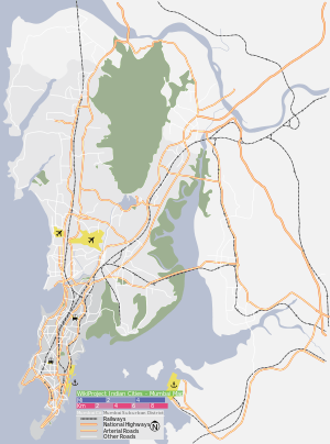 Versova Location in Mumbai, India | |
| Coordinates: 19°07′N 72°49′E / 19.12°N 72.82°ECoordinates: 19°07′N 72°49′E / 19.12°N 72.82°E | |
| Country |
|
| State | Maharashtra |
| District | Mumbai Suburban |
| Metro | Mumbai |
| Languages | |
| • Official | Marathi |
| Time zone | IST (UTC+5:30) |

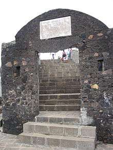
Versova is an upmarket neighbourhood in the north western Mumbai. It is known for its beach and the Versova Fort. It was part of the Portuguese empire up to 1739, when the Portuguese lost this part of their empire to the Maratha Empire.[1]
History
Versova is originally a small fishing village of the Kolis, situated to the north of the old Mumbai city.[2]
The original name of the village is "Vesave", which derives from the Marathi word for "rest" (as in resting place). In 1694, a fleet of Arabs from Muscat landed in Versova and massacred every person they could find in the village.[2] The village is mentioned in the writings of Gemelli Careri in 1695.
Versova came under the Portuguese rule in the medieval period. The Portuguese constructed the Our Lady of Health Church in Versova, and a number of Kolis converted to Christianity during this period. By 1720, it had emerged as a small town, with a small fort and a growing trade in dry fish. In 1739, the Portuguese lost the area to the Marathas, who strengthened the fort. A British force led by Lieutenant-Colonel Henry Keating defeated the Marathas in 1774.[2]
In 1800, the British established a training facility for artillery and engineering cadets. However, the facility was moved to the old Bombay city after a fever epidemic affected nearly all the cadets, and killed many of them. The military establishment was completely removed in 1818.[2] In 1875-86, the exports from the trade amounted to GB£34,403 and the imports in 1876-77 were worth GB£14,784.[2]
Versova beach
The Versova beach faces the Arabian Sea. A large population of Mumbai's fishing community, the Kolis, reside at one end of Versova beach. Fishing is the main industry in this area.
Unlike the Marine Drive, which is guarded by tetrapods, Versova beach uses massive rocks to buffer the buildings from the waves. During high tide, the entire beach goes under water, hence there are no permanent structures on the beach, nor any legal inhabitants.
Over the past few years, there have been attempts by local citizens and the BMC to improve the condition of the beach. The Save Versova Beach Association was formed for the purpose, but the beach still lacks basic facilities such as lifeguards, which are critical considering the treacherous waters.
Recently, the UNEP led a program to clean plastic litter, and over 43 weeks removed more than 2 million kilograms.
 Fishing Boats in Versova
 A well used for methi (fenugreek) cultivation on Versova Beach
 Methi Farmers of Versova
See also
References
- ↑ Location of Vesava - Falling Rain Genomics
- 1 2 3 4 5 Gazetteer of the Bombay Presidency: Tha'na: places of interest. Government Central Press. 1882. pp. 379–380. Retrieved 10 November 2012.
| Pre-colonial | |
|---|---|
| Colonial | |
| Beaches | |
| Places of worship | |
| Cultural | |
| Boulevards | |
| Districts | |
| Shopping | |
| Buildings | |
| Parks, zoos and stadia | |
| Museums | |
| Forts | |
| Restaurants & Bars | |