Silver Creek Township, Clark County, Indiana
| Silver Creek Township | |
|---|---|
| Township | |
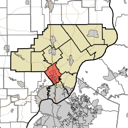 Location of Silver Creek Township in Clark County | |
| Coordinates: 38°23′40″N 85°45′42″W / 38.39444°N 85.76167°WCoordinates: 38°23′40″N 85°45′42″W / 38.39444°N 85.76167°W | |
| Country | United States |
| State | Indiana |
| County | Clark |
| Government | |
| • Type | Indiana township |
| Area | |
| • Total | 16.98 sq mi (44.0 km2) |
| • Land | 16.72 sq mi (43.3 km2) |
| • Water | 0.27 sq mi (0.7 km2) |
| Elevation[1] | 472 ft (144 m) |
| Population (2010) | |
| • Total | 11,858 |
| • Density | 709.3/sq mi (273.9/km2) |
| FIPS code | 18-69696[2] |
| GNIS feature ID | 453848 |
Silver Creek Township is one of twelve townships in Clark County, Indiana. As of the 2010 census, its population was 11,858 and it contained 4,858 housing units.[3]
History
Silver Creek Township was established in or before 1815, but when exactly is uncertain because records have been lost.[4] The township takes its name from Silver Creek, the largest stream in Clark County.[5]
Geography
According to the 2010 census, the township has a total area of 16.98 square miles (44.0 km2), of which 16.72 square miles (43.3 km2) (or 98.47%) is land and 0.27 square miles (0.70 km2) (or 1.59%) is water.[3]
Cities and towns
- Clarksville (north quarter)
- Sellersburg
Unincorporated towns
Adjacent townships
- Union Township (north)
- Charlestown Township (northeast)
- Utica Township (east)
- Jeffersonville Township (south)
- New Albany Township, Floyd County (southwest)
- Carr Township (northwest)
Major highways
Cemeteries
The township contains several cemeteries: Bottorff/Couch, Cremer/Kramer, Cunningham, Hendricks (aka Sarles Cemetery and Hell's Half Acre), Hopewell Baptist Church, Jenkins, Lehmanowsky, Phelps, Poindexter, Plum Run, Sellersburg, Smith Cemetery, St. Joseph Catholic Church, Francis Wells Family (aka Francis Wells), Whalen [6]
References
- ↑ "US Board on Geographic Names". United States Geological Survey. 2007-10-25. Retrieved 2008-01-31.
- ↑ "American FactFinder". United States Census Bureau. Retrieved 2008-01-31.
- 1 2 "Population, Housing Units, Area, and Density: 2010 - County -- County Subdivision and Place -- 2010 Census Summary File 1". United States Census. Retrieved 2013-05-10.
- ↑ History of the Ohio Falls Cities and Their Counties: Precincts of Jefferson County, Ky. General histories of Clark and Floyd counties, Ind. New Albany and Floyd County. Clark County and Jeffersonville. L. A. Williams & Company. 1882. p. 383.
- ↑ Biographical and Historical Souvenir for the Counties of Clark, Crawford, Harrison, Floyd, Jefferson, Jennings, Scott, and Washington, Indiana. Chicago Printing Company. 1889. p. 23.
- ↑ Mauk, Lois. "Clark County, Indiana Cemeteries". usgennet.org. USGenNet. Retrieved 7 September 2014.
External links
Municipalities and communities of Clark County, Indiana, United States | ||
|---|---|---|
| Cities | ||
| Towns | ||
| Townships | ||
| CDPs | ||
| Unincorporated communities |
| |
| Footnotes | ‡This populated place also has portions in an adjacent county or counties | |