Sierra de Caballos
| Sierra de Caballos | |
|---|---|
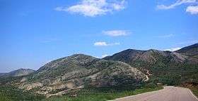 Sierra de los Caballos between Molinos and Berge | |
| Highest point | |
| Peak | Las Artigas |
| Elevation | 1,205 m (3,953 ft) |
| Listing | List of mountains in Aragon |
| Coordinates | 40°49′57″N 0°25′26″W / 40.83250°N 0.42389°WCoordinates: 40°49′57″N 0°25′26″W / 40.83250°N 0.42389°W |
| Geography | |
 Sierra de Caballos Location in Spain | |
| Location |
Maestrazgo, Bajo Aragón, Aragon |
| Parent range | Iberian System, Eastern zone |
| Geology | |
| Orogeny | Alpine orogeny |
| Age of rock | Mesozoic |
| Type of rock | Dolomite and Marl |
| Climbing | |
| Easiest route | From the towns of Seno, Molinos or Berge |
Sierra de Caballos or Sierra de los Caballos is a mountain range in the Maestrazgo and Bajo Aragón comarcas of Aragon, Teruel Province, Spain. The highest point in the range is Las Artigas (1,205 m). The Guadalopillo River flows along the northern side of the range.[1]
Geography
This arid-looking series of parallel ranges is cut by many ravines. It is located north of Castellote, at the eastern end of the Iberian System, roughly between Molinos and Berge. There are many fossils from the Jurassic and Cretaceous periods in this area.
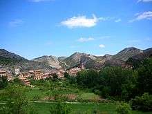
The Ermita de la Virgen de la Peña near Berge, is in the northern side of the Sierra de Caballos. El Picuezo is an original rock formation near Molinos. The impressive Grutas de Cristal "glass caves" are located in the area of these mountains, within Molinos municipal term.[2]
There are other mountain ranges with the name "Sierra de Caballos" in the world. One of them is in Isla de Pinos, Cuba.
See also
References
- ↑ "Guadalopillo" (in Spanish). Gran Enciclopedia Aragonesa. Retrieved 2011-05-30.
- ↑ Caves in Maestrazgo
External links
 Media related to Sierra de los Caballos at Wikimedia Commons
- Sierra de Gúdar - Maestrazgo, Geografía física y humana
- Parque Cultural del Maestrazgo
- Hiking routes
- Molinos - Pozo del Salto