La Moleta (Alfara de Carles)
| La Moleta | |
|---|---|
 | |
| Highest point | |
| Elevation | 812 m (2,664 ft) |
| Coordinates | 40°53′57.4″N 00°25′04.5″E / 40.899278°N 0.417917°ECoordinates: 40°53′57.4″N 00°25′04.5″E / 40.899278°N 0.417917°E |
| Geography | |
| Location | Baix Ebre, Catalonia |
| Parent range | Serra de l'Espina (Catalan Pre-Coastal Range) |
| Geology | |
| Mountain type | Karstic |
| Climbing | |
| Easiest route | From Alfara de Carles |
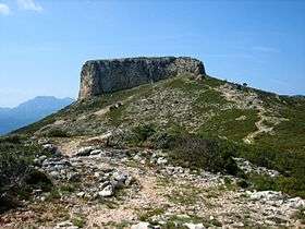
La Moleta or Moleta d'Alfara is a mountain of the Serra de l'Espina, a northern prolongation of the Ports de Tortosa-Beseit, Catalonia, Spain. It has an elevation of 812 metres above sea level.[1] La Moleta rises about 5 km NNW above the village of Alfara de Carles. It is readily identifiable from afar, for its striking squarish shape contrasts sharply with the other summits of the mountain chain.
See also
References
- ↑ "Mapa Topogràfic de Catalunya". Institut Cartogràfic de Catalunya. Retrieved 9 September 2010..
This article is issued from Wikipedia - version of the 3/1/2015. The text is available under the Creative Commons Attribution/Share Alike but additional terms may apply for the media files.