Sierra de Nava Alta
| Sierra de Nava Alta | |
|---|---|
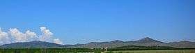 Sierra de Nava Alta seen from near Ricla | |
| Highest point | |
| Peak | Peña de las Armas |
| Elevation | 1,154 m (3,786 ft) |
| Listing | List of mountains in Aragon |
| Coordinates | 41°35′30″N 01°27′58″W / 41.59167°N 1.46611°WCoordinates: 41°35′30″N 01°27′58″W / 41.59167°N 1.46611°W |
| Geography | |
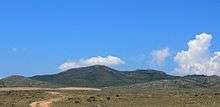
 Sierra de Nava Alta Location in Spain | |
| Location | [Tabuenca (Campo de Borja) [Valdejalón]] (Aragon) |
| State/Province | ES |
| Parent range | Iberian System, northern zone |
| Geology | |
| Orogeny | Alpine orogeny |
| Age of rock | Cretaceous |
| Type of rock | Limestone |
| Climbing | |
| Easiest route | Drive from Épila or Ricla |
Sierra de Nava Alta or Sierra de la Nava Alta is a mountain range in the Valdejalón comarca, Aragon, Spain, located west of the A-121 road, between Fuendejalón and Ricla and east of Tierga and Mesones de Isuela.[1]
Geography
The ridge's highest summits are Peña de las Armas (1154 m), Buitrera de Valdearcos (994 m) and Monegre (922 m).[2]
The Santuario de la Virgen de Rodanas is located in the Sierra de Nava Alta, about 12 km to the west of Épila town. The road to the sanctuary from Épila is not paved.
These mountains are covered with low and mostly sparse maquis shrub, with some juniper, Carrasca (Quercus ilex) and pine trees. They suffered intense exploitation in the past, with overgrazing by cattle and excessive firewood gathering.[3]
See also
References
External links
 Media related to Sierra de Nava Alta at Wikimedia Commons
- Santuario de Rodanas
- Valdejalón