Severn Way
| Severn Way | |
|---|---|
|
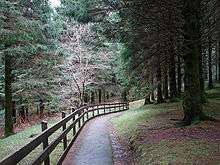
Start of the Severn Way path at the source of the Severn | |
| Length | 210 mi (338 km) |
| Designation | Long-distance trail |
| Trailheads |
Plynlimon Bristol |
| Use | Hiking |
| Elevation | |
| Highest point | Plynlimon, 752 m (2,467 ft) |
| Hiking details | |
| Season | All year |

The Severn Way is a waymarked long-distance footpath in the United Kingdom, which follows the course of the River Severn through Mid Wales and western England.
Distance
The Long Distance Walkers Association gives the Severn Way's length as 360.3 km (223.9 mi).[1]
The route
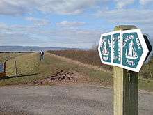
The source of the River Severn is high on Plynlimon,[2] in the uplands of Mid-Wales,[3] from where both river and walk descend[4] to Llanidloes, Newtown, Powys[5] and Welshpool. It then follows the towpath of the Montgomeryshire Canal, passing through Shrewsbury, Shropshire and the Severn Gorge. It passes the cradle of the Industrial Revolution at Ironbridge before passing through Bridgnorth, Hampton Loade and Highley (in Shropshire), and Bewdley[6] in Worcestershire, Stourport-on-Severn, Worcester, Upton-upon-Severn and Tewkesbury. It enters Gloucestershire and passes through Gloucester itself before passing Berkeley Castle and following the Severn Estuary[7] past Slimbridge.[8] Originally the path finished at Severn Beach, but it has recently been extended to Bristol via Lawrence Weston, Shirehampton and through the Avon Gorge.
Connecting trails
The Way links with the Gloucestershire Way, Wye Valley Walk, Worcestershire Way, Staffordshire and Worcestershire Canal Walk, Worcester & Birmingham Canal Walk, Three Choirs Way and Telford and Wrekin Walks, and Shakespeare's Avon Way.[9]
See also
References
- ↑ "Severn Way". Long Distance Walkers Association. Retrieved 21 March 2010.
- ↑ John Lucas. "Trig Pillar, Plynlimon, 752m (C) John Lucas :: Geograph Britain and Ireland". geograph.org.uk. Retrieved 26 October 2015.
- ↑ Philip Halling. "Shelter beside the Severn Way (C) Philip Halling :: Geograph Britain and Ireland". geograph.org.uk. Retrieved 26 October 2015.
- ↑ Graham Horn. "Severn Way above Cefnmawr (C) Graham Horn :: Geograph Britain and Ireland". geograph.org.uk. Retrieved 26 October 2015.
- ↑ Stephen Whittaker and Katharine Oakeshott. "The Severn Way, looking south (C) Stephen Whittaker and Katharine Oakeshott :: Geograph Britain and Ireland". geograph.org.uk. Retrieved 26 October 2015.
- ↑ Penny Mayes. "Severn Way, Blackstone Rock (C) Penny Mayes :: Geograph Britain and Ireland". geograph.org.uk. Retrieved 26 October 2015.
- ↑ Tim. "The banks of the Severn estuary near... (C) Tim :: Geograph Britain and Ireland". geograph.org.uk. Retrieved 26 October 2015.
- ↑ David Gruar. "Reedbeds by the Severn estuary (C) David Gruar :: Geograph Britain and Ireland". geograph.org.uk. Retrieved 26 October 2015.
- ↑ "Severn Way". ldwa.org.uk. Retrieved 26 October 2015.
External links
Transport in Powys | |||||||||||
|---|---|---|---|---|---|---|---|---|---|---|---|
| Road |  | ||||||||||
| Footpaths | |||||||||||
| Cycle routes | |||||||||||
| Railway stations |
| ||||||||||
Coordinates: 52°35′7″N 2°26′6″W / 52.58528°N 2.43500°W