Gloucester
| Gloucester | ||
|---|---|---|
| City & Non-metropolitan district | ||
|
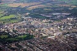
Gloucester and its cathedral | ||
| ||
 City of Gloucester shown within Gloucestershire | ||
| Coordinates: 51°52′N 2°14′W / 51.87°N 2.24°WCoordinates: 51°52′N 2°14′W / 51.87°N 2.24°W | ||
| Sovereign state | United Kingdom | |
| Constituent country | England | |
| Region | South West England | |
| Non-metropolitan county | Gloucestershire | |
| Status | Non-metropolitan district, City | |
| Admin HQ | Gloucester | |
| Government | ||
| • Type | Non-metropolitan district council | |
| • Body | Gloucester City Council | |
| • Leadership | Mayor & Cabinet (TBA (council NOC)) | |
| • MPs | Richard Graham | |
| Area rank | 289th (of 326) | |
| Population (mid-2014 est.) | ||
| • Total | 125,649 | |
| • Rank | 172nd (of 326) | |
| • Ethnicity[1] |
84.6% White British 4.6% White Other 3.5% South Asian 2.8% Black or Black British 1.3% Chinese or Other Asian 3.1% Mixed Race 0.3% Other | |
| Time zone | GMT (UTC0) | |
| • Summer (DST) | BST (UTC+1) | |
| Postcodes | GL1-GL4 | |
| Area code(s) | 01452 | |
| ONS code |
23UE (ONS) E07000081 (GSS) | |
| OS grid reference | SO832186 | |
| Website |
www | |
.svg.png)
Gloucester (![]() i/ˈɡlɒstər/) is a city and district in southwest England, the county city of Gloucestershire. Gloucester lies close to the Welsh border, on the River Severn, between the Cotswolds to the east and the Forest of Dean to the southwest.
i/ˈɡlɒstər/) is a city and district in southwest England, the county city of Gloucestershire. Gloucester lies close to the Welsh border, on the River Severn, between the Cotswolds to the east and the Forest of Dean to the southwest.
Gloucester was founded in AD 97 by the Romans under Emperor Nerva as Colonia Glevum Nervensis, and was granted its first charter in 1155 by King Henry II. Economically, the city is dominated by the service industries, and has a strong financial and business sector,[2] and historically was prominent in the aerospace industry.[3]
History
The origins of the name Gloucester can be traced to Caerloyw in the modern Welsh. There are various appellations in history such as Caer Glow, Gleawecastre, Gleucestre as an early British settlement is not confirmed by direct evidence. However, Gloucester was the Roman municipality of Colonia Nervia Glevensium, or Glevum, built in the reign of Nerva. Parts of the walls can be traced, and a number of remains and coins have been found, though inscriptions are scarce. In Historia Brittonum, a fabled account of the early rulers of Britain, Vortigern's grandfather, Gloiu (or Gloyw Wallt Hir: "Gloiu Long-hair"), is given as the founder of Gloucester.[4][5] Part of the foundations of Roman Gloucester can be seen today in Eastgate Street (near Boots), while Roman tombstones and a range of other Roman artefacts can be seen in Gloucester City Museum.
After the withdrawal on the Roman Empire in the late 4th Century the town returned to the control of Celtic Dubonni tribe. By the Anglo-Saxon Chronicle, Gloucester is shown as part of Wessex from the Battle of Deorham in 577 until 584, when it came under the control of Mercia. The name Gloucester derives from the Anglo-Saxon for fort (Old English ceaster) preceded by Celtic name, which derived from the Roman stem Glev- (pronounced glaiw).[6]Claudia Castra is mentioned in the 18th Century as possible Latin name related to the city.[7]
Gloucester was captured by the Saxons in 577. Its situation on a navigable river, and the foundation in 681 of the abbey of St Peter by Æthelred, favoured the growth of the town; and before the Norman Conquest of England, Gloucester was a borough governed by a portreeve, with a castle which was frequently a royal residence, and a mint. In the early 10th century the remains of Saint Oswald were brought to a small church in Gloucester, bringing many pilgrims to the town. The core street layout is thought to date back to the reign of Ethelfleda in late Saxon times.[8]

In 1051 Edward the Confessor held court at Gloucester and was threatened there by an army led by Godwin, Earl of Wessex, but the incident resulted in a standoff rather than a battle. A unique coin, dated to 1077–80, was discovered, just north of the city, in November 2011. It features the name of the moneyer Silacwine and its place of minting. The Portable Antiquities Scheme said that, until the coin was discovered, there had been no known examples of William I coins minted in Gloucester in this period.[9]
After the Norman Conquest, William Rufus made Robert Fitzhamon the first baron or overlord of Gloucester. Fitzhamon had a military base at Cardiff Castle, and for the succeeding years the history of Gloucester was closely linked to that of Cardiff. During the Anarchy, Gloucester was a centre of support for the Empress Matilda[10] who was supported in her claim to the throne by her half-brother, Fitzhamon's grandson, Robert, 1st Earl of Gloucester (also known as Robert of Gloucester). After this period of strife ended with the marriage of Matilda to Henry I of England, Henry granted Robert possession of Cardiff Castle, and it later passed to Mathilda's son Robert Curthose and his son, William Fitz Robert, 2nd Earl of Gloucester. The story of the Anarchy is vividly told in a series of nineteenth-century paintings by William Burges at the Castle.
King Henry II granted Gloucester its first charter in 1155, which gave the burgesses the same liberties as the citizens of London and Winchester. A a second charter of Henry II gave them freedom of passage on the River Severn. The first charter was confirmed in 1194 by King Richard I. The privileges of the borough were greatly extended by the charter of King John (1200), which gave freedom from toll throughout the kingdom and from pleading outside the borough.
In 1216 King Henry III, aged only ten years, was crowned with a gilded iron ring in the Chapter House of Gloucester Cathedral.[11]
Gloucester's significance in the Middle Ages is underlined by the fact that it had a number of monastic establishments, including St Peter's Abbey founded in 679 (later Gloucester Cathedral), the nearby St Oswald's Priory, Gloucester founded in the 880s or 890s, Llanthony Secunda Priory, founded 1136 as a retreat for a community of Welsh monks (now near the western bypass),[12] the Franciscan Greyfriars community founded in 1231 (near Eastgate Shopping Centre),[13] and the Dominican Blackfriars community founded in 1239 (Ladybellegate Street).[14] It also has some very early churches including St Mary de Lode Church, Gloucester near the Cathedral and the Norman St Mary de Crypt Church, Gloucester in Southgate Street.
In the Middle Ages the main export was wool which came from the Cotswolds and was processed in Gloucester; other exports included leather and iron (tools and weapons). Gloucester also had a large fishing industry at that time. In 1223 thatched roofs were banned after a massive fire that destroyed a part of Gloucester.
One of the most significant periods in Gloucester's history began in 1378 when Richard II of England convened Parliament in the city. Parliaments were held there until 1406 under Henry IV of England. The Parliament Rooms at the Cathedral remain testimony to this important time.
Gloucester was incorporated by King Richard III in 1483, the town being made a county in itself. This charter was confirmed in 1489 and 1510, and other charters of incorporation were received by Gloucester from Queen Elizabeth I and King James I. Gloucester was the site of the execution by burning of John Hooper, Bishop of Gloucester in the time of Queen Mary in 1555. In 1580 Gloucester was awarded the status of a port by Queen Elizabeth I. The Siege of Gloucester in 1643 was a battle of the English Civil War in which the besieged parliamentarians emerged victorious.
The sixteenth and seventeenth centuries saw the foundation of two of Gloucester's grammar schools: the Crypt School in 1539 and Sir Thomas Rich's School in 1666. Both still flourish as grammar schools today, along with Ribston Hall and the High School for Girls, Gloucester (Denmark Road).
Gloucester's most important citizens include Robert Raikes (founder of the Sunday School movement) who is still commemorated by the name of a pub in Southgate Street. Its most infamous citizen was Fred West.
In July 2007, Gloucester was hit badly by a flood that struck Gloucestershire and its surrounding areas. Hundreds of homes were flooded, but the event was most memorable because of its wider impact – about 40,000 people were without power for 24 hours, and the entire city (plus surrounding areas) was without piped water for 17 days.
In 2009, Gloucester Day was revived as an annual day of celebration of Gloucester's history and culture. The day originally dates from the lifting of the Siege of Gloucester in 1643, during which the city held out against Royalist forces during the First English Civil War.[15]
Coat of arms


Gloucester is one of few cities in England with the distinction of having two coats of arms. The first consists of three chevrons surrounded by ten roundels. The chevrons come from the arms of the Clare family, who were earls of Gloucester from the 12th to the 14th centuries, while the roundels come from the arms of the Bishop of Worcester, whose bishopric historically encompassed Gloucester. This coat is the older of the two, though it is usually termed the "Commonwealth coat", as it was not officially granted to the city until 1652, during the Commonwealth period. The crest and supporters (lions bearing broadswords and trowels) were also adopted at this time, along with the motto Fides Invicta Triumphat ("unconquered faith triumphs", in reference to the royalist siege withstood by the city in 1643).
The second coat, termed the "Tudor coat", was granted in 1538. It features the roses of York and Lancaster, the boar's head of Richard III, a ceremonial sword and cap, and two horseshoes surrounded by nails, to represent Gloucester's historical association with ironworking.
Though grants made by Commonwealth heralds were nullified after the restoration, the Commonwealth coat continued to be used by the city in favour of the uglier Tudor coat. The Commonwealth coat, along with the crest and supporters, was legally granted to the city by letters patent dated 16 April 1945. This was reconfirmed in 1974 following the local government changes of that year.[16][17]
On 23 June 2016 the people of Gloucester voted to leave the European Union, in accordance with the overall outcome of the UK-wide referendum.
Government
| Gloucester City Council | |
|---|---|
| Type | |
| Type | |
| Structure | |
| Seats | 39 councillors |
 | |
|
21 / 39 | |
|
10 / 39 | |
|
7 / 39 | |
Vacant |
1 / 39 |
| Elections | |
| First past the post | |
Last election | 5 May 2016 |
| Website | |
|
www | |
Gloucester is split into 18 wards, with a total of 39 councillors elected to serve on the City Council. Following the last election in 2016 there were 22 Conservative Councillors, 10 Labour Councilors, and 7 Liberal Democrat councillors.[18]
History
The district was formed from the County Borough of Gloucester on 1 April 1974 under the Local Government Act 1972. The parish of Quedgeley was subsequently added in 1991.
Responsibilities
Gloucester City Council carries out a variety of district council functions including:
- Benefits - Housing and Council Tax
- Car Parking
- Concessionary Travel
- Council Tax - Administration and Collection
- Elections and Electoral Registration
- Environmental Health (includes Domestic and Commercial Premises)
- Food Safety and Hygiene Complaints
- Noise Pollution and Pest Control
- Housing Administration
- Licensing
- Caravan Sites
- Planning, including Planning Applications, Advice and Appeals
- Public Conveniences
- Health and Leisure Centres
- Refuse Collection
- Recycling
- Tourism and Visitor Information.
Geography

Gloucester is the county town of Gloucestershire, and is the 53rd largest settlement in the United Kingdom by population.[19] In 2011 the city had a population of 121,900. However the built-up area extends beyond the city boundary, with several outlying districts. The 2011 census gave the population of the whole "Gloucester Urban Area" as 149,820.
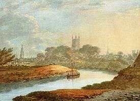
The city is located on the eastern bank of the River Severn, sheltered by the Cotswolds to the east, while the Forest of Dean and the Malvern Hills rise to the west and north, respectively. Gloucester is a port, linked via the Gloucester and Sharpness Canal which runs from Gloucester's docks to the Severn Estuary, allowing larger ships to reach the docks than would be possible on the tidal reaches of the river itself, which go well north of the city to Haw Bridge. The wharfs, warehouses and the docks themselves fell into disrepair until their renovation in the 1980s. They now form a public open space. Some warehouses now house the Gloucester Waterways Museum, others were converted into residential flats, shops and bars. Additionally, the Soldiers of Gloucestershire Museum is located in the Custom House. Next to the museum is Gloucester Yacht Club. The port still houses the most inland RNLI lifeboat in the United Kingdom.
Gloucester is made up of a variety of neighbourhoods, some of which correspond to electoral divisions of the City Council.
- Abbeydale
- Abbeymead
- Alney Island
- Barnwood
- Barton and Tredworth
- Coney Hill
- Elmbridge
- Hempsted
- Hucclecote
- Kingsholm
- Linden
- Longlevens
- Matson
- Podsmead
- Quedgeley†
- St. Pauls
- Tuffley
- Wotton
- Westgate
- White City, Gloucester
†Quedgeley is the only civil parish within the city boundary, and as such has its own parish council.[20] Quedgeley was transferred to the district of Gloucester in 1991.[21] The remainder of the city (the former county borough of Gloucester) is unparished.
Attractions

Gloucester Cathedral, in the north of the city near the river, originates in the foundation of an abbey dedicated to Saint Peter in 681. It is the burial place of King Edward II and Walter de Lacy. The cathedral (mainly its cloisters) was used for corridor scenes in the films Harry Potter and the Philosopher's Stone, Harry Potter and the Chamber of Secrets and Harry Potter and the Half Blood Prince It was also used for a scene in Sherlock Christmas special, where upon the crypt was used.[22] Attached to the deanery is the Norman prior's chapel. In St Mary's Square outside the Abbey gate, the Bishop of Gloucester, Bishop John Hooper, was martyred under Queen Mary I in 1555.
A good number of medieval and Tudor period gabled and half timbered houses survive from earlier periods of Gloucester's history. At the point where the four principal streets intersected stood the Tolsey (town hall), which was replaced by a modern building in 1894. None of the old public buildings are left except for the New Inn in Northgate Street. It is a timbered house, with strong, massive external galleries and courtyards. It was built around 1450 by John Twyning, a monk.[23]

King's Square is at the heart of the city centre and occupies what was once a cattle market and bus station. Officially opened in 1972, it was the centrepiece of a radical redesign of the city, The Jellicoe Plan, which was first proposed in 1961. It stands beside the Debenham's (formerly Bon Marché) store built in the early 1960s. Many of the features of the redevelopment have since been dismantled; the brutalist concrete fountains in the middle of the square have gone and the overhead roadways which linked three multi storey car parks around the centre have been either closed or dismantled. The present main bus station received a Civic Trust Award in 1963 but is now in a state of disrepair. In 2012 a £60 million plan was unveiled to revamp the square.[24] In 2014 the prominent Golden Egg restaurant was demolished and a new look public space was created. A prior archaeological dig revealed a Roman house underneath.[25]
An indoor market opened in Eastgate Street in 1968, followed by the Eastgate Shopping Centre in 1973.[26] The corner of Eastgate Street and Brunswick Road was redeveloped around this time; Roman remains unearthed below street level in 1974 may be seen through a glass observation panel outside the Boots building, which opened in 1980. The HSBC building on the Cross was renovated and a modern extension added to the Westgate Street aspect in 1972 which received a Civic Trust Award. Sainsbury's opened a supermarket in Northgate Street in 1970; it retains its original interior. Opposite, Tesco opened a large two-storey supermarket in 1974 on the site of a demolished chapel. This is now occupied by Wilkinson's after Tesco moved to Quedgeley in 1984.
Gloucester Leisure Centre opened on the corner of Eastgate Street and Bruton Way in September 1974 and was redeveloped and rebranded (as "GL1") in August 2002. Gloucester Central railway station was rebuilt in 1977 to serve both the original traffic to that railway station and the services from the closed Gloucester Eastgate railway station (former Midland Railway) which had stood on another site further east along the same road. Opposite the station stands one of the city's largest office blocks, Twyver House, opened in 1968, which houses the regional Land Registry. The main shopping streets were pedestrianised in the late 1980s.
The 1966 Heights Plan for Gloucester sought to restrict construction of tall buildings and defend spiritual values by protecting views of Gloucester Cathedral.[27] The tower of Gloucestershire Royal Hospital, started in 1970 and completed in August 1975, can be seen from miles around. In Brunswick Road, a brown concrete tower, which housed classrooms at the Gloucestershire College of Arts and Technology (now moved to a site near Llanthony Bridge). The tower was added incongruously to the existing 1930s Technical College buildings in 1971 which has now been demolished. Clapham Court, a tall block of flats, stands in Columbia Close, between London Road and Kingsholm Road. It was built in 1972 and stands on what was once Columbia Street in a small district formerly known as Clapham.
Other features of interest include the museum and school of art and science, the former county jail (on the site of a Saxon and Norman castle), the Shire Hall (now headquarters of the County Council) and the Whitefield memorial church. A park in the south of the city contains a spa, a chalybeate spring having been discovered in 1814. West of this, across the canal, are the remains (a gateway and some walls) of Llanthony Secunda Priory, a cell of the mother abbey in the Vale of Ewyas, Monmouthshire, which in the reign of King Edward IV became the secondary establishment.
Culture
The Three Choirs Festival, originating in the 18th century and one of the oldest music festivals in the British Isles, is held in Gloucester every third year, the other venues being Hereford and Worcester. Gloucester hosted the festival in 2013, and it is next due in the city in 2016.
The city's main theatre and cultural venue is the Guildhall.[28] The Guildhall hosts a huge amount of entertainment, including live music, dance sessions, a cinema, bar, café, art gallery and much more. The Leisure Centre, GL1, hosts concerts and has a larger capacity than the Guildhall.
The annual Gloucester International Rhythm and Blues Festival takes place at the end of July and early August.[29] Gloucester International Cajun and Zydeco Festival, the largest in the UK and longest-running in Europe, runs for a weekend in January each year.[30] A Medieval Fayre is held in Westgate Street each year during the summer.
Gloucester is also noted as the home of the Frightmare Halloween Festival, the largest Halloween festival in the South West.[31]
The main museum in the city is the The Museum of Gloucester but there are several other important museums.
The Tailor of Gloucester House which is dedicated to the author Beatrix Potter can be found near the cathedral.
Since 2013 Gloucester has marked Armed Forces Day with a Drum Head Service held on College Green in the shadow of the cathedral. This is followed by a parade of serving forces, veterans and cadets through the city centre to the docks for a family day with military and military-related charity displays and entertainment in Back Badge Square in front of the Soldiers of Gloucestershire Museum.
Nature in Art is a gallery dedicated to the display of works of art inspired by the natural world.
A popular and well known rhyme about the city: Doctor Foster went to Gloucester in a shower of rain, he stood in a puddle right up to his middle and never went there again.
Churches
Gloucester has many churches, and historically has also had many dissenting chapels. It may have been the old proverb "as sure as God's in Gloucester" that provoked Oliver Cromwell to declare that the city had "more churches than godliness". Gloucester was the host of the first Sunday school in England; this was founded by Robert Raikes in 1780. Four of the churches that are of special interest are
- St Mary de Lode – with a Norman tower and chancel, and a monument of Bishop John Hooper. It was built on the site of an ancient Roman temple which became the first Christian church in Britain
- St Mary de Crypt – with a cruciform structure of the 12th century. It has later additions, such as the tower. Also the site of the Schoolroom in which the Crypt School was formed
- St Michael's Church – said to have been connected with St Peter's ancient abbey
- St Nicholas's Church – founded by the Normans but with many additions since then.
In the neighbourhood around St Mary de Crypt there are slight remains of Greyfriars and Blackfriars monasteries, and also of the city wall. Under the Golden Fleece (The Monks Bar) and Saracen's Head inns early vaulted cellars still remains. In addition, in the city is St Peter's Roman Catholic Church, a Grade II* listed building.[32]
During the construction of the Boots store on the corner of Brunswick Road and Eastgate Street in 1974, Roman remains were found. These can be seen through a glass case on the street. At the back of the Gloucester Furniture Exhibition Centre part of the city's South Gate can be seen.
Education
See also List of schools in Gloucestershire.
There are three endowed schools: The King's School, refounded by Henry VIII as part of the cathedral establishment; the school of St Mary de Crypt now known as "The Crypt School, Gloucester" since it moved to a mile from town centre to Podsmead, founded by Dame Joan Cooke in the same reign (1539), Sir Thomas Rich's School, previously known as Sir Thomas Rich's Bluecoat Hospital for Boys (1666); The High School for Girls (1883) ; and Ribston Hall High School for Girls. Comprehensives include Millbrook Academy, Beaufort Co-operative Academy, St Peter's High School (Catholic school), Chosen Hill School, Severn Vale School, Gloucester Academy, Barnwood Park Arts College and Churchdown School Academy.
Transport

Gloucester is served by the M5 motorway, which runs to the east of the city. Junction 12 serves south Gloucester and Quedgeley. Junction 11a serves central Gloucester and junction 11 serves north Gloucester. The A38 runs north–south through Gloucester connecting the city with Tewkesbury and Bristol. The A40 runs west to east, connecting Gloucester with Cheltenham to the east (via a dual carriageway section known as The Golden Valley Bypass) and the Forest of Dean and Monmouth to the West. The A46 and A4173 links Gloucester and Stroud, and the A417 links Gloucester with Cirencester in the south east and Ledbury in the north west. Gloucester has a number of Cycle Paths.
Until the construction of the Severn Bridge in 1966, Gloucester was the lowest bridging point on the river and hence was an important settlement on the route between London and South Wales. The Severn is split into two branches at this point, so the road crosses first onto Alney Island and then onto the western bank. A road bridge on this western side at Over, built by Thomas Telford in 1829, still stands, notable for its very flat arch construction, but its fragility and narrow width means it is no longer used for traffic, and since 1974 it has been paralleled by a modern road bridge. There is a rail crossing, also across Alney Island, which was the lowest on the river until the opening of the Severn Railway Bridge in 1879, followed by the Severn Tunnel in 1886, although following the dismantling of the former in 1970 Gloucester once again has the furthest downstream rail bridge crossing of the Severn.
Gloucester railway station has frequent trains to London Paddington, Reading, Bristol, Cardiff Central, Nottingham and Birmingham. Gloucester was the site of the Gloucester Railway Carriage and Wagon Company railway works, which have now closed. Buses are run by Stagecoach West, operating from its depot on London Road. For longer, slower journeys, National Express operate a number of services including the 444 to London and the 222 to Heathrow and Gatwick airports.
Gloucester is linked to the Severn Estuary by the Gloucester and Sharpness Canal, which is navigable by small coasters. The city is linked to the River Avon and Stourport-on-Severn by the navigable part of the River Severn, which is navigable by river craft of a few hundred tonnes' displacement. Gloucester Docks mark the Normal Tidal Limit (NTL) of the river.[33] Gloucester was formerly linked to Ledbury and Hereford by the Herefordshire and Gloucestershire Canal; and subsequently by the Ledbury and Gloucester Railway, which used the southern section of the former canal, until it also closed in 1964. This canal is now being restored, and the restored canal basin in the Gloucester suburb of Over is a local attraction.
Business and industry
Gloucester has a long history in the aerospace business. In 1926 the Gloucestershire Aircraft Company at Brockworth changed its name to the Gloster Aircraft Company because international customers claimed that the name "Gloucestershire" was too difficult to spell. A sculpture in the city centre celebrates Gloucester's aviation history and its involvement in the jet engine. Frank Whittle's pioneering turbojet engine powered the first British jet aircraft, which first flew at the company's airfield at Brockworth. This is commemorated by the pub "The Whittle" at Gloucester Business Park, which now occupies the site. Roads in the business park are named after other Gloster aircraft, and a small statue overlooks the site of the old main runway. Messier-Dowty's landing gear plant and Smiths Aerospace Dowty Propellers plants are on the outskirts of the city.
The large insurer Ecclesiastical Insurance is based in the city, as is its owner, the charity Allchurches Trust.[34] Lloyds Banking Group and TSB Bank each have an office in Barnwood, the former previously having been the headquarters of Cheltenham & Gloucester Building Society.[35]
Gloucester was the home of Priday, Metford and Company Limited, a family milling firm which survived for over one hundred years, and hydraulic engineering firm Fielding & Platt.
Gloucester Business Park is a business park on the outskirts on the city and is home to a number of big brands including Fortis and Detica.[36]
Sport and leisure
- Gloucester was a host city for the Rugby World Cup in 2015, hosting four matches at Kingsholm Stadium with national teams from Japan, Georgia, USA, Scotland, Tonga and Argentina
- Kingsholm Stadium is the ground of Gloucester Rugby, founded in 1873, one of Europe's top rugby union clubs and a member of the Aviva Premiership.
- Meadow Park was the home of Gloucester City A.F.C., founded in 1883, of the National League North. The club currently play matches at archrivals Cheltenham Town's Whaddon Road Stadium in Cheltenham due to the 2007 Floods and have been homeless since then.
- The Gloucester Cricket Festival is held in Gloucester at the King's School.
- The Matson district is home to Gloucester Ski and Snowboard Centre dry slope skiing facility (with two slopes of 220m and 150m respectively down the side of Robinswood Hill[37]) and an 18-hole golf course.
- Gloucester City Swimming Club competes in county and national swimming championships.[38]
- Gloucester City Hockey Club is based at the Oxstalls Sports Park, with teams entered in the West Hockey Leagues.[39]
- Bentham Domes on the outskirts of Gloucester boasts one of the largest 5-a-side leagues in Europe.
- The Gloucester Banshees American Football are based in the city at Oxstalls Tennis Centre, and play at a national level in the British American Football League
- The Gloucester Vipers (seniors) & Gloucester Boxers (junior) Skater Hockey Club. Compete in BIPHA (puck) & BISHA (ball) leagues.
- The University of Gloucestershire All-Golds is the city's only professional Rugby League club, playing in the semi professional Championship 1 from 2013. They play their home games at the Prince of Wales Stadium in Cheltenham
- Gloucestershire Warriors founded in 1997 are an amateur Rugby League team that play in the Conference League South playing home games at the Oxstalls Sports Park
- Gloucestershire University run Rugby League teams in the BUCS league
- Public sports facilities are focused on the GL1 leisure centre, a large modern sports centre with several swimming pools, a multi-use sports hall, indoor bowls room, squash courts, gym and health spa. There is also a new Esporta complex in Brockworth.
Media
The Citizen, published by Local World (Trinity Mirror) is Gloucester's main daily newspaper, which shares all its content with the Gloucestershire Echo and the weekly Forester covering the Forest of Dean and Chepstow.
BBC Radio Gloucestershire has its studios on London Road in Gloucester. Heart Gloucestershire, previously Severn Sound, is based in Eastgate Shopping Centre. Gloucester FM is a community radio station specialising in black and urban music. Sunshine Radio, which broadcasts from Herefordshire and Monmouthshire, can be heard clearly across the county. It also broadcasts on the Gloucester DAB Multiplex.
Local radio is broadcast from transmitters on Churchdown Hill (Chosen Hill), and for television reception Gloucester is in a transmitter overlap area between Ridge Hill (Midlands) and Mendip (West), although the West regional broadcasts cover the city editorially.
A number of TV and film productions have been filmed in Gloucester; most notably at the cathedral and docks. These include three of the Harry Potter films, Doctor Who, Outlaw[40] and Alice in Wonderland: Through the Looking Glass.[41]
Crime
| Offence | Gloucester | South West | England |
|---|---|---|---|
| Violence with Injury | 7.0 | 5.4 | 5.5 |
| Violence without Injury | 5.0 | 4.5 | 5.1 |
| Robbery | 0.9 | 0.4 | 1.2 |
| Theft from the Person | 1.1 | 0.8 | 1.9 |
| Criminal Damage and Arson | 11.0 | 9.4 | 9.3 |
| Domestic Burglary | 5.5 | 2.6 | 4.1 |
| Non Domestic Burglary | 5.8 | 3.9 | 4.1 |
| Vehicle Offences | 7.5 | 5.1 | 6.9 |
| Drug Offences | 4.0 | 3.0 | 3.6 |
| Sexual Offences | 1.3 | 1.0 | 0.9 |
According to a Home office report Gloucester had the third highest murder rate in England and Wales between October 2014 and September 2015.[43]
Twin cities
Gloucester is twinned with Metz, France, since 1967;[44][45] Trier, Germany, since 1957; Saint Ann, Jamaica, since 1987; and Gouda, Netherlands, since 1972.
Notable people
Notable residents of Gloucester have included:
- Alastair Cook (b. 1984), cricketer
- Alex Cuthbert (b. 1990), Welsh international, British & Irish Lions rugby player.
- Andy Hazell (b. 1978), rugby player
- Bridget Christie (b. 1972), comedian
- Button Gwinnett (1735 – 19 May 1777), second signatory of United States Declaration of Independence.
- Charles Wheatstone (1802–1875), scientist and inventor
- David Lawrence (b. 1964), former England cricketer.
- Dynamite MC (b. 1973), musician.
- Fred West (1941–1995) and Rose West (b. 1953) serial killers who tortured, raped and murdered at least 12 young women.
- George Whitefield (1714–1770), Church of England minister and a leader in the Methodist movement
- Hubert Cecil Booth (1871–1955), inventor of the vacuum cleaner
- Ivor Gurney (1890–1937), composer and poet
- Jack Russell (cricketer, born 1963) (b. 1963), cricketer
- Jemmy Wood (1756–1836), legendary miser and owner of the Gloucester Old Bank.
- John Clarke Whitfield (1770–1836), organist and composer
- John Stafford Smith (1750–1836), composer of the American national anthem
- Marcel Garvey (b. 1983), rugby player
- Mary-Jess Leaverland (b. 1990), singer
- Mike Teague (b. 1960), former England rugby union footballer
- Nathan Sykes (b. 1993), former member of British boyband the Wanted
- Phil Greening (b. 1975), rugby player
- Paul Groves (b. 1947), poet
- Robert Raikes the Elder (1690–1757), "the printer of Gloucester", founder of the Gloucester Journal, early pioneer of press freedom, buried in church of St Mary de Crypt
- Robert Raikes (1735–1811), English philanthropist and Anglican layman, noted for his promotion of Sunday schools
- Samuel Daukes (1811–1880), architect[46]
- Scott Redding (b. 1993), motorcyclist
- Simon Pegg (b. 1970), actor, comedian and writer
- Thomas Machen (c. 1541–1614), mayor of Gloucester three times and MP once
- Thomas Raikes (1741–1813), banker and merchant in London, who as Bank of England governor issued the first £1 and £2 English pound notes in 1797
- Tina May (b. 1961), jazz vocalist
- Tom Goddard (1900–1966), cricketer
- William Ernest Henley (1849–1903), poet, critic and editor
See also
References
- ↑ Neighbourhood Statistics. "Ethnic Group, 2011 (KS201EW)". Office for National Statistics. Retrieved 2014-02-20.
- ↑ "The Economy in Gloucester". Gloucester City Council. Archived from the original on 14 August 2007. Retrieved 2014-02-20.
- ↑ "The Museum". Jet Age Museum. Retrieved 2014-02-20.
- ↑ Nennius (828). Historia Brittonum.
- ↑ Robert Vermaat (2008). "Gloiu Long-Hair". vortigernstudies.org.uk.
- ↑ Kenneth Cameron: English Place Names
- ↑ Robert Ainsworth. Thesaurus Linguae Latinae Compendiarius:. Mount, 1752 - 802 pages.
- ↑ "Anglo-Saxon Gloucester: c.680 - 1066". british-history.ac.uk.
- ↑ "'Unique' 11th Century coin discovered near Gloucester". BBC Gloucestershire. 2012-02-16. Retrieved 2014-02-20.
- ↑ Gesta Stephani, §47
- ↑ "Short History of the City of Gloucester, Gloucestershire".
- ↑ "Llanthony Secunda Priory".
- ↑ "History of Greyfriars - English Heritage".
- ↑ http://www.gloucesterblackfriars.co.uk/
- ↑ Tradition revived for city pride. BBC News, 5 September 2009. Retrieved 11 September 2011.
- ↑ "Gloucester City Council". Civic Heraldry of England and Wales.
- ↑ N M Herbert (ed.). A History of the County of Gloucester. London: Victoria County History.
- ↑ "Your Councillors". 1 December 2016.
- ↑ List of largest United Kingdom settlements by population
- ↑ "Quedgeley Parish Council". quedgeley-pc.gov.uk.
- ↑ "The Gloucestershire (District Boundaries) Order 1991 (S.I. 1991/281)". legislation.gov.uk. Retrieved 3 February 2015.
- ↑ "Potter filming moves to cathedral". BBC Newsround. 7 February 2008. Retrieved 2008-04-10.
- ↑ New Inn. English Heritage. Retrieved 27 June 2011.
- ↑ "Kings Square £60m revamp signed by developer". BBC News. 27 September 2012. Retrieved 21 January 2015.
- ↑ "New dawn for King's Square in Gloucester as Golden Egg piazza finally revealed". Gloucester Citizen. 9 April 2014. Retrieved 21 January 2015.
- ↑ "Celebrating 40 years of the Eastgate Shopping Centre". Gloucestershire Live. 4 July 2013. Retrieved 26 August 2016.
- ↑ Geoffrey & Susan Jellicoe. "The Landscape of Man", pp356-7. pub. Thames & Hudson, 1975.
- ↑ "Guildhall". Gloucester.gov.uk. Retrieved 2010-07-17.
- ↑ "Gloucester International Rhythm & Blues Festival 2010".
- ↑ "Gloucester Cajun and Zydeco Festival". Gloucester Guildhall. Archived from the original on 12 February 2014. Retrieved 2014-02-20.
- ↑ "Frightmare at Over Farm". Heart Gloucestershire. Heart. Retrieved 1 November 2015.
- ↑ Roman Catholic Church of St Peter, Gloucester from British Listed Buildings, retrieved 3 January 2016
- ↑ getamap
.ordnancesurvey getamap.ordnancesurvey.co.uk.co .uk /getamap /frames .htm?mapAction=gaz&gazName=p&gazString=GLOUCESTER - ↑ Charity Commission. Allchurches Trust, registered charity no. 263960.
- ↑ "legacygloucestershireecho.co.uk".
- ↑ "Occupiers in Gloucester Business Park". Retrieved 2010-08-03.
- ↑ "Gloucester Ski facilities". Gloucesterski.com. Retrieved 2010-07-17.
- ↑ Gloucester City Swimming Club Archived 1 December 2008 at the Wayback Machine.
- ↑ "Gloucester City Hockey Club". gloucestercityhc.co.uk. Retrieved 17 October 2014.
- ↑ "Things to Do".
- ↑ "Tall ships bring treasure to Gloucester". The Gloucester Citizen. 25 September 2014. Retrieved 25 September 2014.
- ↑ Neighbourhood Statistics Office for National Statistics Area: Gloucester (Local Authority)
- ↑ Scott, Patrick (22 January 2016). "Murder capital of the country revealed - but where is your town?".
- ↑ "British towns twinned with French towns". Archant Community Media Ltd. Archived from the original on 5 July 2013. Retrieved 2013-07-11.
- ↑ "Metz Municipal Council" (in French). Retrieved 1 June 2012.
- ↑ Tim Bridges 2000 rev. ed. 2005 Churches of Worcestershire Logaston Press, Logaston, Herefordshire pp106-107
Further reading
- Rudder, S. (1781) The History and Antiquities of Gloucester. Cirencester: Samuel Rudder. (free download)
External links
| Wikimedia Commons has media related to Gloucester. |
| Wikivoyage has a travel guide for Gloucester. |
- Gloucester City Council Local government web site
- Gloucester at DMOZ
- BBC archive film of Gloucester from 1980
- BBC archive film of Gloucester from 1987
- Gloucester City Council YouTube channel
| Unitary authorities | |
|---|---|
| Boroughs or districts | |
| Major settlements |
|
| Rivers | |
| Topics | |