Gloucestershire Way
| Gloucestershire Way | |
|---|---|
|
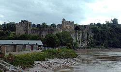
Chepstow Castle lies on the trail | |
| Length | 100 mi (161 km) |
| Location | Gloucestershire, England |
| Trailheads |
Tutshill 51°38′53″N 2°39′58″W / 51.648°N 2.666°W Tewkesbury 51°59′46″N 2°08′13″W / 51.996°N 2.137°W |
| Use | Hiking |
The Gloucestershire Way is a long-distance footpath, in the English country of Gloucestershire. It was devised by Gerry and Kate Stewart, of the Ramblers Association and Tewkesbury Walking Club. The 100-mile (160-kilometre) route, which uses existing Rights of Way, goes from Tutshill, just north of Chepstow, crosses the river Severn at Gloucester, proceeding then to Tewkesbury, with a 'Worcestershire Way Link'.
In detail the stages are:
- Chepstow to Parkend – 13.5 miles (21.7 km)
- Parkend to May Hill – 14 miles (23 km)
- May Hill to Gloucester – 13 miles (21 km)
- Gloucester to Crickley – 12 miles (19 km)
- Crickley to Salperton – 12 miles (19 km)
- Salperton to Stow-on-the-Wold – 11 miles (18 km)
- Stow to Winchcombe – 13 miles (21 km)
- Winchcombe to Tewkesbury – 11.5 miles (18.5 km)
- Worcestershire Way Link – 12 miles (19 km)
External links
References
Stewart G (1996), The Gloucestershire Way, published by Countryside Matters, ISBN 0-9527870-0-8
This article is issued from Wikipedia - version of the 10/28/2015. The text is available under the Creative Commons Attribution/Share Alike but additional terms may apply for the media files.