Serra de l'Espadella
| Serra de l'Espadella | |
|---|---|
 | |
| Highest point | |
| Peak | Espadella |
| Elevation | 968 m (3,176 ft) |
| Listing | List of mountains in the Valencian Community |
| Coordinates | 40°32′52″N 0°5′23″E / 40.54778°N 0.08972°ECoordinates: 40°32′52″N 0°5′23″E / 40.54778°N 0.08972°E |
| Geography | |
 Serra de l'Espadella Location in Spain | |
| Location | Baix Maestrat, Valencian Community |
| Parent range | Iberian System, Eastern end |
| Geology | |
| Orogeny | Alpine orogeny |
| Type of rock | Karstic |
| Climbing | |
| First ascent | Unknown |
| Easiest route | From Vallivana or from Xert |
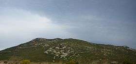
Serra de l'Espadella (Spanish: Sierra de la Espandela)[1] is an over 4 km (2 mi) long mountain range in the Baix Maestrat comarca, Valencian Community, Spain. Its highest point is Espadella (968 m). These mountains are frequently covered in snow in the winter.
Geography
This mountain chain rises south of the Serra del Turmell, between the almost abandoned village of Vallivana and the Moles de Xert, to the northeast of the Serra de Vallivana, on the other side of the valley through which the N-232 road passes. This sparsely populated mountain area has the most important forested zone of the region.[2]
The main wild animals in these unpopulated mountains are the Spanish Ibex, Roe Deer and Wild Boar.
See also
References
- ↑ Vicenç M. Rosselló i Verger, Toponímia, geografia i cartografia
- ↑ José Quereda Sala, Les Moles de Xert,; Análisis Geomorfológico (Spanish)
External links
| Wikimedia Commons has media related to Serra de l'Espadella. |
- El País Valencià poble a poble; comarca a comarca - El Baix Maestrat
- Els Ports : Vallivana – Vereda del Turmell - Vallivana
This article is issued from Wikipedia - version of the 11/22/2016. The text is available under the Creative Commons Attribution/Share Alike but additional terms may apply for the media files.