Santa Barbara, Pangasinan
| Santa Barbara | ||
|---|---|---|
| Municipality | ||
 | ||
| ||
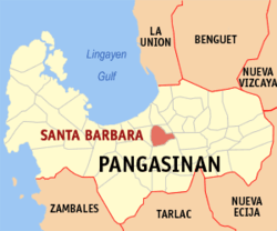 Map of Pangasinan showing the location of Santa Barbara | ||
.svg.png) Santa Barbara Location within the Philippines | ||
| Coordinates: 16°00′11″N 120°24′03″E / 16.00306°N 120.40083°ECoordinates: 16°00′11″N 120°24′03″E / 16.00306°N 120.40083°E | ||
| Country |
| |
| Region | Ilocos (Region I) | |
| Province | Pangasinan | |
| District | 3rd district of Pangasinan | |
| Founded | October 30, 1741 | |
| Barangays | 29 | |
| Government[1] | ||
| • Mayor | Carlito S. Zaplan | |
| Area[2] | ||
| • Total | 61.37 km2 (23.70 sq mi) | |
| Population (2010)[3] | ||
| • Total | 76,637 | |
| • Density | 1,200/km2 (3,200/sq mi) | |
| Time zone | PST (UTC+8) | |
| ZIP code | 2419 | |
| Dialing code | 75 | |
| Income class | 1st class | |
| Website |
pangasinan | |

Santa Barbara is a first class municipality in the province of Pangasinan, Philippines. According to the 2010 census, it has a population of 76,637 people.[3]
Geography
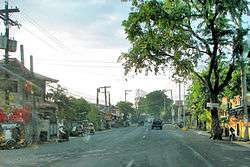
The town of Santa Barbara lies on a plain terrain in the northern part of the Agno Valley, at the center of Pangasinan. It is just west of the business center of Urdaneta City, with centuries-old mango trees lining the national highway to Santa Barbara. Fifteen kilometers further west is Dagupan City along the Lingayen Gulf, and to its south is the town of Malasiqui and beyond it the City of San Carlos.
Barangays
Santa Barbara is politically subdivided into 29 barangays.[2]
- Alibago
- Balingueo
- Banaoang
- Banzal
- Botao
- Cablong
- Carusocan
- Dalongue
- Erfe
- Gueguesangen
- Leet
- Malanay
- Maningding
- Maronong
- Maticmatic
- Minien East
- Minien West
- Nilombot
- Patayac
- Payas
- Tebag West
- Tebag East
- Poblacion Norte
- Poblacion Sur
- Sapang
- Sonquil≠
- Tuliao
- Ventinilla (Ventinilla West)
- Primicias (Ventinilla East)
Local government
Elected officials 2010–2013:
- Municipal Mayor: Carlito S. Zaplan
- Municipal Vice Mayor: Joel F. delos Santos
- Sangguniang Bayan Members
- Norman “Manok” Q. Dalope
- Crisanto Ok Ok De Guzman
- Isagani “Sonny” L. Ico
- Roger Zaplan
- Rogelio “Roger” Navarro
- Sherwin Pioquinto
- Freddie Salon
Economy
Although a large part of Sta. Barbara is fast getting urbanized, the main economic activity remains farming. Rice remains its main crop with 6,662 hectares or close to all its total tillable lands devoted to rice farming. The second most important crop is mango of which the town is famous as the home of age-old Philippine mango seedling nurseries, a veritable home industry in town.
Rice and mango are the only crops that are raised in all its 29 barangays. The third most important crop are a variety of vegetables followed by corn. Legumes and root crops are grown in small quantities.
Their livestock include cattle, carabao, hogs, goats and dogs. They likewise raise native chickens for their food and some poultry farms commercially produce chicken layers and broilers.
Out of the farm produce, Sta. Barbara has developed its own food processing industry that includes the making of rice cakes like latik and suman, nata-de coco making, and pickles from different fruits.
It likewise has a highly developed clay tiles and pottery industry coupled with non-farm based processing industries like candle and soap making and the making of hollow blocks for construction. The town has one industrial plant, the Ginebra San Miguel gin manufacturing plant in Tebag West barangay along the national highway towards Dagupan.
The town’s business and trading center in and around the public market features a variety of wholesale and retail and other services establishments from farm inputs to construction materials. The market serves as the place where its people buy their needs and sell their produce. Transportation between the commercial center and the many barangays is served by a large fleet of individually owned tricycles.
Sta. Barbara’s close proximity to Urdaneta City, has, however, constrained the growth of its trading sector.
Demographics
| Population census of Santa Barbara | ||
|---|---|---|
| Year | Pop. | ±% p.a. |
| 1990 | 47,746 | — |
| 1995 | 54,116 | +2.37% |
| 2000 | 64,261 | +3.75% |
| 2007 | 73,025 | +1.78% |
| 2010 | 76,637 | +1.77% |
| 2015 | 82,012 | +1.30% |
| Source: National Statistics Office[3][4] | ||
Sta. Barbara is populated mainly by Pangasinense natives with a sprinkling of other ethnic groups led by the Ilocanos.
It is largely a suburban community with much of its population densely concentrated in 29 barangays. By the year 2008, the town’s population was projected to have reached 86,269, with a growth rate of 3.75 percent per year for the past seven years, faster than the national average.
More than half of the families or roughly 60 percent are farmers who till the northern part of the rich Agno Valley. Average family income as of the 2000 national census, was a low P9,662.67 a year. Maybe because the average farming family does not buy, but produce the bulk of its own food, family expenditures were lower at P7,545.42. The average Sta. Barbaran family has a disposable income of over P2,000 a year despite statistical data that had shown that a family In the Ilocos region needed PhP 14,749.00 in income a year to survive.
A high level of self-sufficiency in food is likewise gleaned in the town’s minimal rate of malnutrition of only .50 percent severely malnourished out of 5.12 percent malnourished -pre-school children. The public school system is also proud of having an unusually low drop-out rate in the elementary grades and high school.
Poverty rate in Sta. Barbara is high as average income is even lower than the regional poverty threshold. But food self-sufficiency has saved its town folks from sliding to the ranks of the very poor.
Climate
| Climate data for Santa Barbara, Pangasinan | |||||||||||||
|---|---|---|---|---|---|---|---|---|---|---|---|---|---|
| Month | Jan | Feb | Mar | Apr | May | Jun | Jul | Aug | Sep | Oct | Nov | Dec | Year |
| Average high °C (°F) | 31 (88) |
31 (88) |
33 (91) |
34 (93) |
34 (93) |
33 (91) |
32 (90) |
31 (88) |
31 (88) |
32 (90) |
31 (88) |
31 (88) |
32 (89.7) |
| Average low °C (°F) | 21 (70) |
21 (70) |
23 (73) |
25 (77) |
25 (77) |
25 (77) |
25 (77) |
24 (75) |
24 (75) |
24 (75) |
23 (73) |
22 (72) |
23.5 (74.3) |
| Average precipitation mm (inches) | 4.3 (0.169) |
19.1 (0.752) |
27.3 (1.075) |
45.2 (1.78) |
153.3 (6.035) |
271.3 (10.681) |
411.1 (16.185) |
532 (20.94) |
364.4 (14.346) |
182.5 (7.185) |
56.3 (2.217) |
24.4 (0.961) |
2,091.2 (82.326) |
| Average rainy days | 3 | 2 | 3 | 5 | 14 | 17 | 22 | 23 | 21 | 13 | 7 | 4 | 134 |
| Source: World Weather Online[5] | |||||||||||||
Religion
The heritage Santa Barbara Parish of the Holy Family Church, built in 1716, is part of the Roman Catholic Archdiocese of Lingayen-Dagupan, Vicariate III. Rev. Fr. Fidelis B. Layog is its Parish Priest and Rev. Fr. Jim Cerezo is its Parish Vicar.
 Façade of the Church
 Parish Office and Convent Façade
 Interior
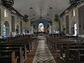 Far view of the altar
 Interior of the Oratory
 Oratory
Suburban housing
Also owing to its suburban location and easy access to three nearby cities, Urdaneta, San Carlos and Dagupan, Sta. Barbara has attracted subdivision developers, both for middle-class and low-cost markets. As of mid-2008, it has attracted to its territory eight different housing projects including subdivisions developed by the company owned by Senate President Manny Villar and a pilot Gawad Kalinga housing project for the very poor embarked by the town government and its private sector partners.
Infrastructure
The town has a total of 137.509 linear kilometers of road network classified into national, provincial, municipal and barangay roads. All the national highways passing through town and those under the town government have been paved. The 17 kilometers of provincial roads are about three fourths paved while more than half (67.10%) of 92.5 kilometers of barangay roads otherwise known as farm to market roads, needed concreting.
Unlike paved roads, electricity has reached all of the town’s 29 barangays with about 80 percent of all households served. Power rates are much lower than in Metro Manila for both households, commercial and industrial users.
Two of the biggest landline telephone companies, PLDT and Digitel, plus one wireless company, Smart, serves the communication needs of the town although units to users ratio as of 2007 was still low at one phone for every 93 residents.
The local government-run Rural Health Unit and its 10 satellite barangay health centers, plus seven private medical clinics and one dental clinic serve the basic health needs of Sta. Barbara residents.
Education
Sta. Barbara has an extensive public elementary and high school system. It has a total of 26 elementary schools supervised by two school districts plus seven public high schools. These are manned by 418 teachers and other school personnel with a student of over 15,000 children in any given year.
Their healthy teacher to pupil ratio averaging one to 34 in the elementary grades and one is to 41 in high school and their minimal drop-out rates of two percent in the elementary grades and less than four in every 100 students that enter high school. This was the state of things in Sta. Barbara when the local leadership changed in mid-2007.
Gallery
 Town hall
 Halls of Justice, Municipal Court
 Water district tower
 Façade of the Don Daniel B. Maramba High School
 Santa Barbara Public Plaza
 Grave of Daniel B. Maramba
References
- ↑ "Official City/Municipal 2013 Election Results". Intramuros, Manila, Philippines: Commission on Elections (COMELEC). 1 July 2013. Retrieved 7 September 2013.
- 1 2 "Province: PANGASINAN". PSGC Interactive. Makati City, Philippines: National Statistical Coordination Board. Retrieved 26 November 2012.
- 1 2 3 "Total Population by Province, City, Municipality and Barangay: as of May 1, 2010" (PDF). 2010 Census of Population and Housing. National Statistics Office. Retrieved 26 November 2012.
- ↑ "Province of Pangasinan". Municipality Population Data. LWUA Research Division. Retrieved 7 September 2013.
- ↑ "Santa Barbara, Pangasinan: Average Temperatures and Rainfall". World Weather Online. Retrieved 31 October 2015.
External links
| Wikimedia Commons has media related to Santa Barbara, Pangasinan. |
- Official Website of Sta. Barbara, Pangasinan
- Philippine Standard Geographic Code
- Philippine Census Information
- Local Governance Performance Management System
- Santa Barbara, Pangasinan
 |
Mangaldan | Mapandan | | |
| Calasiao | |
|||
| ||||
| | ||||
| San Carlos | Malasiqui | Urdaneta |
Lingayen (capital) | |
| Municipalities |
|
| Component cities | |
| Independent component city |
|
| Barangays | |