Manaoag, Pangasinan
| Manaoag | ||
|---|---|---|
| Municipality | ||
 | ||
| ||
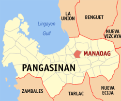 Map of Pangasinan showing the location of Manaoag | ||
.svg.png) Manaoag Location within the Philippines | ||
| Coordinates: 16°02′38″N 120°29′08″E / 16.04389°N 120.48556°ECoordinates: 16°02′38″N 120°29′08″E / 16.04389°N 120.48556°E | ||
| Country |
| |
| Region | Ilocos (Region I) | |
| Province | Pangasinan | |
| District | 4th district of Pangasinan | |
| Founded | 1600 | |
| Barangays | 26 | |
| Government[1] | ||
| • Mayor | Kim Mikael De Guzman Amador | |
| Area[2] | ||
| • Total | 55.95 km2 (21.60 sq mi) | |
| Population (2010)[3] | ||
| • Total | 64,578 | |
| • Density | 1,200/km2 (3,000/sq mi) | |
| Time zone | PST (UTC+8) | |
| ZIP code | 2430 | |
| Dialing code | 75 | |
| Income class | 1st | |
| Website |
www | |

Manaoag (Pangasinan: Baley na Manaoag), is a first class municipality in the province of Pangasinan, Philippines. According to the 2010 census, it has a population of 64,578 people.[3]
Manaoag is bordered by Pozorrubio in the north, Urdaneta City and Mapandan in the south, Laoac in the east, and San Jacinto in the west.
Etymology
Manaoag came from the Pangasinan Language word "Mantaoag" which means "to call".
Barangays
Manaoag is politically subdivided into 26 barangays:[2]
- Babasit
- Baguinay
- Baritao
- Bisal
- Bucao
- Cabanbanan
- Calaocan
- Inamotan
- Lelemaan
- Licsi
- Lipit Norte
- Lipit Sur
- Matulong
- Mermer
- Nalsian
- Oraan East
- Oraan West
- Pantal
- Pao
- Parian
- Poblacion
- Pugaro
- San Ramon
- Santa Ines
- Sapang
- Tebuel
Demographics
| Population census of Manaoag | ||
|---|---|---|
| Year | Pop. | ±% p.a. |
| 1990 | 45,339 | — |
| 1995 | 49,705 | +1.74% |
| 2000 | 54,743 | +2.09% |
| 2007 | 62,684 | +1.89% |
| 2010 | 64,578 | +1.09% |
| 2015 | 69,497 | +1.41% |
| Source: National Statistics Office[3][4] | ||
Our Lady of Manaoag
The town is a popular local pilgrimage site as it enshrines a 17th-century ivory statue of St Mary under the title of Nuestra Señora del Rosario de Manaoag ("Our Lady of the Rosary of Manaoag"). Legend has it that a young man had a vision of St Mary, who told him to have the shrine built. Famous souvenirs include candles, rosaries, and ampullae of blessed oil with flowers (which supposedly has healing properties), as well as less religious ones such as bagoóng monamon and tupig.
List of Cultural Properties of Manaoag
| Cultural Property wmph identifier |
Site name | Description | Province | City/Municipality | Address/Location | Coordinates | Image |
|---|---|---|---|---|---|---|---|
| Minor Basilica of Our Lady of the Rosary of Manaoag | first chapel built in 1600's; rebuilt during World War II | Pangasinan | Manaoag, Pangasinan | 16°02′39″N 120°29′20″E / 16.044044°N 120.488858°E |  | ||
| Our Lady of Manaoag College | formely an old convent beside Manaoag Church | Pangasinan | Manaoag, Pangasinan | 16°02′35″N 120°29′22″E / 16.043014°N 120.489346°E | 
| ||
| Manaoag Town Hall | where the Municipal Government of Manaoag is located | Pangasinan | Manaoag, Pangasinan | 16°02′37″N 120°29′14″E / 16.043631°N 120.487125°E |  | ||
| Veterans Freedom Hall | Pangasinan | Manaoag, Pangasinan | 16°02′37″N 120°29′14″E / 16.043500°N 120.487178°E |  | |||
| Llamido House | Constructed in 1960's | Pangasinan | Manaoag, Pangasinan | 351 N. Garcia Road (Guico Street) | 16°02′34″N 120°29′16″E / 16.042757°N 120.487908°E | 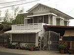 | |
| Lazaro Corpuz House | Constructed in 1935 | Pangasinan | Manaoag, Pangasinan | N. Garcia Road (Guico Street) | 16°02′33″N 120°29′18″E / 16.042459°N 120.488209°E | 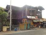 | |
| Macario Corpuz House | Constructed in 1920's | Pangasinan | Manaoag, Pangasinan | 285 N. Garcia Road (Guico Street) | 16°02′32″N 120°29′18″E / 16.042353°N 120.488329°E |  | |
| Filomena House | Constructed in 1950's | Pangasinan | Manaoag, Pangasinan | 281 N. Garcia Road (Guico Street) | 16°02′33″N 120°29′19″E / 16.042447°N 120.488539°E |  | |
| Tanguilig House | Constructed in 1920's | Pangasinan | Manaoag, Pangasinan | 240 N. Garcia Road (Guico Street) | 16°02′31″N 120°29′19″E / 16.041939°N 120.488616°E | 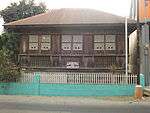 | |
| Dionisio Guico House | Constructed in 1958 | Pangasinan | Manaoag, Pangasinan | 272 N. Garcia Road (Guico Street) | 16°02′31″N 120°29′20″E / 16.042013°N 120.488932°E |  | |
| Mendoza House | Constructed in 1930's | Pangasinan | Manaoag, Pangasinan | 279 N. Garcia Road (Guico Street) | 16°02′32″N 120°29′19″E / 16.042287°N 120.488692°E | 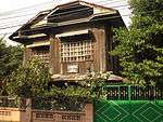 | |
| Felipe Guico House | Constructed in 1940's | Pangasinan | Manaoag, Pangasinan | 270 N. Garcia Road (Guico Street) | 16°02′32″N 120°29′20″E / 16.042119°N 120.488817°E |  | |
| Berceles House | Constructed in 1960's | Pangasinan | Manaoag, Pangasinan | 271 N. Garcia Road (Guico Street) | 16°02′31″N 120°29′19″E / 16.041851°N 120.488730°E | 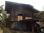 | |
| Bautista House | Constructed in 1930's | Pangasinan | Manaoag, Pangasinan | Guico Street | 16°02′29″N 120°29′20″E / 16.041473°N 120.488806°E |  |
Climate
| Climate data for Manaoag, Pangasinan | |||||||||||||
|---|---|---|---|---|---|---|---|---|---|---|---|---|---|
| Month | Jan | Feb | Mar | Apr | May | Jun | Jul | Aug | Sep | Oct | Nov | Dec | Year |
| Average high °C (°F) | 29 (84) |
29 (84) |
30 (86) |
32 (90) |
33 (91) |
33 (91) |
33 (91) |
33 (91) |
33 (91) |
32 (90) |
31 (88) |
29 (84) |
31.4 (88.4) |
| Average low °C (°F) | 21 (70) |
21 (70) |
22 (72) |
23 (73) |
24 (75) |
24 (75) |
24 (75) |
24 (75) |
23 (73) |
23 (73) |
22 (72) |
21 (70) |
22.7 (72.8) |
| Average precipitation mm (inches) | 127.5 (5.02) |
115.8 (4.559) |
129.7 (5.106) |
141.1 (5.555) |
248.2 (9.772) |
165 (6.5) |
185.3 (7.295) |
161.9 (6.374) |
221.4 (8.717) |
299.5 (11.791) |
199 (7.83) |
188.7 (7.429) |
2,183.1 (85.948) |
| Average rainy days | 17 | 17 | 17 | 15 | 20 | 19 | 19 | 20 | 21 | 20 | 17 | 19 | 221 |
| Source: World Weather Online[5] | |||||||||||||
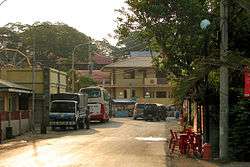
Images
 Manaoag Town Hall (Poblacion)
 Manaoag Tourism Youth Center
 St. Camillus College of Manaoag and Maternity & Polyclinic
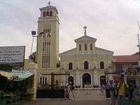 Basilica of Our Lady of the Holy Rosary of Manaoag
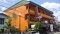 Hotel Manaoag (Soriano Street
 Aloragat bridge and Aloragat River
References
- ↑ "Official City/Municipal 2013 Election Results". Intramuros, Manila, Philippines: Commission on Elections (COMELEC). 1 July 2013. Retrieved 5 September 2013.
- 1 2 "Province: PANGASINAN". PSGC Interactive. Makati City, Philippines: National Statistical Coordination Board. Retrieved 26 November 2012.
- 1 2 3 "Total Population by Province, City, Municipality and Barangay: as of May 1, 2010" (PDF). 2010 Census of Population and Housing. National Statistics Office. Retrieved 26 November 2012.
- ↑ "Province of Pangasinan". Municipality Population Data. LWUA Research Division. Retrieved 5 September 2013.
- ↑ "Manaoag, Pangasinan: Average Temperatures and Rainfall". World Weather Online. Retrieved 12 October 2015.
External links
| Wikimedia Commons has media related to Manaoag. |
- Manaoag, Pangasinan
- Philippine Standard Geographic Code
- Philippine Census Information
- Local Governance Performance Management System
- Our Lady of Manaoag
- Manaoag Shrine
 |
San Jacinto | Pozorrubio | | |
| |
Laoac | |||
| ||||
| | ||||
| Mapandan | Urdaneta |
Lingayen (capital) | |
| Municipalities |
|
| Component cities | |
| Independent component city |
|
| Barangays | |