Bolinao, Pangasinan
| Bolinao | ||
|---|---|---|
| Municipality | ||
 | ||
| ||
| Motto: Bayan Ko, | ||
 Map of Pangasinan showing the location of Bolinao | ||
.svg.png) Bolinao Location within the Philippines | ||
| Coordinates: 16°20′N 119°53′E / 16.333°N 119.883°ECoordinates: 16°20′N 119°53′E / 16.333°N 119.883°E | ||
| Country |
| |
| Region | Ilocos (Region I) | |
| Province | Pangasinan | |
| District | 1st district of Pangasinan | |
| Founded | 1575 | |
| Barangays | 30 | |
| Government[1] | ||
| • Mayor | Arnold Del Fierro Celeste | |
| • Vice Mayor | Alfonso Del Fierro Celeste | |
| Area[2] | ||
| • Total | 197.22 km2 (76.15 sq mi) | |
| Population (2010)[3] | ||
| • Total | 74,545 | |
| • Density | 380/km2 (980/sq mi) | |
| Time zone | PST (UTC+8) | |
| ZIP code | 2406 | |
| Dialing code | 75 | |
| Income class | 3rd class | |
| Website |
bolinao | |

Bolinao is a third class municipality in the province of Pangasinan, Philippines. According to the 2010 census, it has a population of 74,545 people.[3]
Sea urchins are regularly harvested at Isla Silaki, Bolinao.[4]
Barangays
Bolinao is politically subdivided into 30 barangays.[2]
- Arnedo
- Balingasay
- Binabalian
- Cabuyao
- Catuday
- Catungi
- Concordia (Pob.)
- Culang
- Dewey
- Estanza
- Germinal (Pob.)
- Goyoden
- Ilog-Malino
- Lambes
- Liwa-liwa
- Lucero
- Luciente 1.0 (J.Celeste)
- Luciente 2.0
- Luna
- Patar
- Pilar
- Salud
- Samang Norte
- Samang Sur
- Sampaloc
- San Roque
- Tara
- Tagapuro
- Tupa
- Victory
- Zaragoza
History
Folk etymology attributes the name "Bolinao" or this remote fishing enclave from the fish piece "monamon" but commonly called "Bolinao" by the Tagalogs, Bicolanos and the Visayans. A theory also points out that once upon a time "pamulinawen" trees grew luxuriantly along its shores, thus, the Ilocano migrants who crossed the Lingayen Gulf named it phonetically similar to the name of the tree. Nowadays, however, such tree does not exist anymore.
Unofficial records narrate the story of an Italian missionary named Blessed Odorico who said the first mass in Bolinao Bay, baptizing several locals while he was on his way to China. He took refuge in what is now known as Bolinao during a storm in 1324. Two centuries later, an account narrates the arrival of Juan de Salcedo and his crew reached Bolinao and chanced upon a Chinese Sampan who captured a native chieftain. Salcedo and his men liberated the natives and the latter immediately pledged vassalage to the King of Spain.[5]
According to oral history, the town of Bolinao used to be a small settlement in what is now Barrio Binabalian in Santiago Island, then having a population of just over a hundred families. It is said that Captain Pedro Lombi founded the town of Bolinao in 1575. A decade later, Dominican Friar Esteban Marin became the first Spanish missionary to evangelize the people of Bolinao. For two years he worked in Bolinao before he was assigned as prior in Batac, Ilocos Norte.[5]
The Dominicans ended their service in 1607 to be replaced by the Augustinian Recollects headed by Fr. Jeronimo de Cristo and Dr. Andres del Espiritu Santo. At this time, the old town of Bolinao was still located along the coast of Pangasinan. Due to pirate attacks, the town was transferred to the mainland in 1609.
This town formerly included the neighboring town of Anda, but Anda became an independent municipality on May 26, 1849.
First Mass
On November 18, 2007, Bolinao challenged the historical fact that the first Mass was held on March 31, 1521, Easter Sunday, at Limasawa in Southern Leyte. Memorial markers (donated by Italian priest Luigi Malamocco, 62, from Odorico’s hometown of Friuli, Italy) were set in the town’s church and on Santiago Island, claiming that in 1324, Franciscan missionaries led by an Italian priest named Odorico celebrated a thanksgiving Mass thereat and also baptized natives.[6]
Hard coal spill
Bolinao Mayor Alfonso Celeste said the local government will file damage suit against Indonesian owners of the barge APOL 3003. The University of the Philippines Marine Science Institute (UPMSI) stated that the environmental damage was P 54.9 million ($1 =- P 40). The barge towed by a tug boat from Indonesia to the power plant in Sual, Pangasinan on November 27 when Typhoon “Mina” winds destroyed its anchor and rope, then hurled to Ilog Malino reef, spilling 95% of its coal cargo. The hard coal spill spread to 330,000 square metres of coral and sea grass areas.[7]
Bolinao Skull
The Bolinao Skull is a skull dated between the 14th and 15th centuries A.D. recovered in the Balingasay archeological site in Bolinao. The Bolinao Skull is the most well known artifact from the site, noted for the intricate gold ornamentation formed in the shape of scales on the surfaces of its teeth. However, 67 other skulls containing teeth with less extensive gold ornamentation were also found at the Balingasay site. The skull is now displayed within the Museo ng Lahing Pilipino, or Museum of the Filipino People.[8]
World War II
The Japanese Imperial forces were landed and occupied the town municipality of Bolinao on December 1941 and established of the military garrison of the Imperial Japanese Armed Forces. The joint military force of the United States, Australian and Philippine Commonwealth troops including the local resistance fighters liberated the town municipality of Bolinao on January 1945 due to retake in Luzon and aftermath in World War II.
Demographics
| Population census of Bolinao | ||
|---|---|---|
| Year | Pop. | ±% p.a. |
| 1990 | 49,202 | — |
| 1995 | 53,127 | +1.45% |
| 2000 | 61,068 | +3.03% |
| 2007 | 69,568 | +1.81% |
| 2010 | 74,545 | +2.55% |
| 2015 | 82,084 | +1.85% |
| Source: National Statistics Office[3][9] | ||
Language
The word Bolinao is a term used for the name of the town, the people, and the language.
The Bolinao people generally speak Ilocano, Tagalog, Pangasinan, and their own unique native language called Bolinao, which is also used in a near town, Anda --- former barangay of the Bolinao town. The Bolinao language is closely related to Sambalic. Bolinao was part of the province of Zambales from mid-18th and was turned over to Pangasinan in 1903. Most people generally understand and speak English because of the annual visit of local and foreign tourists in the different bodies of water in the town including beaches, falls, caves, river, and other protected sanctuaries which are prohibited areas for tourists.
Ilocano speaking barangays: Arnedo, Balingasay, Cabuyao, Catuday, Catungi, Culang, Estanza, Ilog-Malino, Lambes, Luna, Patar, Sampaloc, Samang Sur, Samang Norte, San Roque, Tara, Tupa, Zaragoza.
Bolinao speaking barangays: Binabalian, Concordia, Dewey, Germinal, Goyoden, Lucero, Luciente 1st, Luciente 2nd, Liwa-liwa, Pilar, Salud, Victory.
The Mother Tongue Policy of the DepEd is enforced in the elementary schools of these barangays to empower the native languages in town.
Climate
| Climate data for Bolinao, Pangasinan | |||||||||||||
|---|---|---|---|---|---|---|---|---|---|---|---|---|---|
| Month | Jan | Feb | Mar | Apr | May | Jun | Jul | Aug | Sep | Oct | Nov | Dec | Year |
| Average high °C (°F) | 31 (88) |
31 (88) |
33 (91) |
34 (93) |
34 (93) |
33 (91) |
32 (90) |
31 (88) |
31 (88) |
32 (90) |
31 (88) |
31 (88) |
32 (89.7) |
| Average low °C (°F) | 21 (70) |
21 (70) |
23 (73) |
25 (77) |
25 (77) |
25 (77) |
25 (77) |
24 (75) |
24 (75) |
24 (75) |
23 (73) |
22 (72) |
23.5 (74.3) |
| Average rainfall mm (inches) | 4.3 (0.169) |
19.1 (0.752) |
27.3 (1.075) |
45.2 (1.78) |
153.3 (6.035) |
271.3 (10.681) |
411.1 (16.185) |
532.0 (20.945) |
364.4 (14.346) |
182.5 (7.185) |
56.3 (2.217) |
24.4 (0.961) |
2,091.2 (82.331) |
| Average rainy days | 3 | 2 | 3 | 5 | 14 | 17 | 22 | 23 | 21 | 13 | 7 | 4 | 134 |
| Source: World Weather Online[10] | |||||||||||||
Cape Bolinao Lighthouse
The Cape Bolinao Lighthouse at Patar rises 351 feet (107 m) above sea level atop Punta Piedra Point, a towering hill of solid rock which is the sharp point of Cape Bolinao itself. It was built by the Americans in 1903 on a 351 feet (107 m) high promontory at the western part of Cape Bolinao, the lighthouse still sends signals to vessels passing by the area.
The lighthouse provides a panoramic view of a portion of the 1,269 hectare Cape Bolinao Dendro Thermal Ipil-Ipil Plantation on a land area where archaeological excavations have revealed relics from the 14th to the 15th centuries. Filipino, British and American engineers constructed the lighthouse in 1905.
According to the Bureau of Geodetic Surveys, the land elevation is 250 feet (76 m). Visibility is 20 miles (32 km; 17 nmi) at midsea towards the lighthouse in Poro Point. The winding stairway has 6 platforms with 20 steps or rungs for a total of 120 steps plus 14 more to the illumination room, or an over-all total of 134 steps.
Schools
Tertiary schools:
- Bolinao Lighthouse School of Tourism and Learning Center Ilog-Malino Campus
Secondary schools:
- Public
- Arnedo National High School
- Balingasay National High School
- Binabalian National High School
- Bolinao School of Fisheries
- Catubig Integrated School
- Catuday National High School
- Dewey National High School
- Ilog-Malino National High School
- Liwa-liwa Integrated School
- Luciente II National High School
- Luna National High School
- Pilar National High School
- Sampaloc National High School
- Tupa Integrated School
- Zaragoza National High School
- Private
- Cape Bolinao High School
Elementary schools:
- Public
- Arnedo Elementary School
- Balingasay Elementary School
- Beda Elementary School
- Binabalian Elementary School
- Bolinao Integrated School (formerly Bolinao Central School)
- Cabuyao Elementary School
- Catubig Integrated School
- Catuday Elementary School
- Catungi Elementary School
- Culang Elementary School
- Dewey Elementary School
- Estanza Elementary School
- Gagaban Elementary School
- Goyoden Elementary School
- Ilog-Malino Elementary School
- Lambes Elementary School
- Liwa-liwa Integrated School
- Lucero Elementary School
- Luciente 1st Elementary School
- Luciente 2nd Elementary School
- Luna Elementary School
- Patar Elementary School
- Pilar Elementary School
- Salud Elementary School
- Samang Norte Elementary School
- Samang Sur Elementary School
- Sampaloc Elementary School
- San Roque Elementary School
- Tanobong Elementary School
- Tara Elementary School
- Tupa Integrated School
- Victory Elementary School
- Yabyaban Elementary School
- Zaragoza Elementary School
- Private
- Senor Santiago Learning Center
- Bolinao Christian School
Images
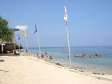 Sunny white beach at Rock Garden Resort, Bolinao
 Patar White Beach, only walking distance to Cape Bolinao's Lighthouse
References
- ↑ "Official City/Municipal 2013 Election Results". Intramuros, Manila, Philippines: Commission on Elections (COMELEC). 1 July 2013. Retrieved 3 September 2013.
- 1 2 "Province: PANGASINAN". PSGC Interactive. Makati City, Philippines: National Statistical Coordination Board. Archived from the original on 14 November 2012. Retrieved 26 November 2012.
- 1 2 3 "Total Population by Province, City, Municipality and Barangay: as of May 1, 2010" (PDF). 2010 Census of Population and Housing. National Statistics Office. Archived from the original (PDF) on 15 November 2012. Retrieved 26 November 2012.
- ↑ GMA NEWS.TV, Sea creatures of Silaki
- 1 2 St. James the Great Parish, Bolinao, Pangasinan @405. Bolinao Church Parish Office. 25 July 2014.
- ↑ Inquirer.net, Bolinao stakes claim to Mass held in 1324 Archived March 12, 2009, at the Wayback Machine.
- ↑ Inquirer.net, Bolinao to sue barge owners for coal spill
- ↑ "VCM". masterpieces.asemus.museum. Retrieved 2016-05-16.
- ↑ "Province of Pangasinan". Municipality Population Data. LWUA Research Division. Retrieved 3 September 2013.
- ↑ "Bolinao, Philippines: Average Temperatures and Rainfall". World Weather Online. Retrieved 15 September 2014.
External links
| Wikimedia Commons has media related to Bolinao, Pangasinan. |
- Philippine Standard Geographic Code
- Philippine Census Information
- Local Governance Performance Management System
 |
South China Sea | Lingayen Gulf | | |
| South China Sea | |
Anda | ||
| ||||
| | ||||
| Bani |
Lingayen (capital) | |
| Municipalities |
|
| Component cities | |
| Independent component city |
|
| Barangays | |