Sand Island Light (Alabama)
 Sand Island lighthouse - 1962 | |
 Alabama | |
| Location |
Sand Island Mobile County Alabama United States |
|---|---|
| Coordinates | 30°11′16″N 88°03′02″W / 30.18778°N 88.05056°WCoordinates: 30°11′16″N 88°03′02″W / 30.18778°N 88.05056°W |
| Year first constructed |
1838 (first) 1859 (second) 1864 (third) |
| Year first lit | 1873 (current) |
| Automated | 1921 |
| Deactivated | 1933 |
| Foundation | stone |
| Construction | brownstone tower |
| Tower shape | tapered cylindrical tower with balcony and lantern |
| Markings / pattern | unpainted tower, black lantern and balcony |
| Height | 131 feet (40 m) |
| Original lens |
1838: 14 lamps with 16-inch reflectors 1859: First order Fresnel lens 1862-63: Fourth order Fresnel lens 1873: Second order Fresnel lens, now at the Fort Morgan Museum |
| Range | 0 miles (0 km) |
| Characteristic | F W |
| Fog signal | bell struck every 20 seconds |
| ARLHS number | USA-723.[1][2] |
| Managing agent |
Town of Dauphin Island[3] |
|
Sand Island Light | |
| Nearest city | Fort Morgan, Alabama |
| Area | less than one acre |
| Architectural style | Italianate |
| NRHP Reference # | 75000305[4] |
| Added to NRHP | November 12, 1975 |
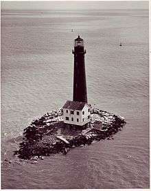
Sand Island Light is a decommissioned lighthouse located at the southernmost point of the state of Alabama, United States, near Dauphin Island, at the mouth of Mobile Bay, Alabama. It is located roughly three miles offshore from the primary Mobile Bay entrance, bounded on the east by Mobile Point and on the west by Dauphin Island.[5] The lighthouse is 132 feet (40 m) high.
History

An earlier lighthouse on Sand Island was destroyed during the Civil War, on February 23, 1863 by Confederate John W. Glenn.[5]
Sand Island itself faced continuous erosion, to the point where granite blocks were being added to the island to try and stave off the erosion and loss of the lighthouse.[5] Restoration efforts resulted primarily in stabilization of the island through 2008.[5] Sand Island Lighthouse's dire situation is similar to "its sister light", the Morris Island Lighthouse, near Charleston, South Carolina. Both lighthouses were situated on sandy islands that have eroded, leaving the towers surrounded by water.[5]
It is on the Lighthouse Digest Doomsday List as one of the most endangered lighthouses in the country.[6] The Sand Island Lighthouse (and Mobile Bay light) were damaged by Hurricane Ivan in 2004 and Hurricane Katrina in 2005. Repairing that damage will further delay restoration efforts.[6]
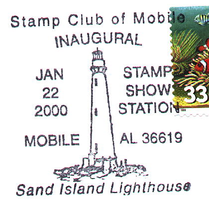
The image of this lighthouse was used as a stamp cancellation.[7]
See also
References
- ↑ Amateur Radio Lighthouse Society, Sand Island (Gulf of Mexico) Light ARLHS USA-723
- ↑ Amateur Radio Lighthouse Society, World List of Lights.
- ↑ Sand Island The Lighthouse Directory. University of North Carolina at Chapel Hill. Retrieved 6 June 2016
- ↑ National Park Service (2010-07-09). "National Register Information System". National Register of Historic Places. National Park Service.
- 1 2 3 4 5 "Sand Island, AL". LighhouseFriends.com. Retrieved 22 April 2007.
- 1 2 Rowlett, Russ. "Lighthouses of the United States: Alabama". The Lighthouse Directory. University of North Carolina at Chapel Hill.
- ↑ Lighthouse Stamp Society, Sand Island Light cancellation.
External links
- Alabama Lighthouse Association.
- Anderson, Kraig, Lighthouse Friends, Sand Island Lighthouse.
- Sand Island Light at Dauphin Island Foundation.
- Gordon Vernon, 2006 photograph.
- Sand Island Light, Alabama Lighthouse Association.
- Sand Island Preservation Group.
- Sand Island Lighthouse Photos (1859–2004) and information on the Sand Island Lighthouse
| Wikimedia Commons has media related to Sand Island Light (Alabama). |
