Dauphin Island, Alabama
| Dauphin Island, Alabama | |
|---|---|
| Town | |
| Town of Dauphin Island | |
|
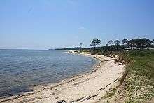
Fort Gaines on the eastern end of Dauphin Island | |
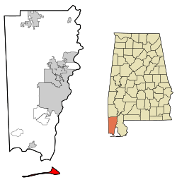 Location in Mobile County and the state of Alabama | |
| Coordinates: 30°15′23″N 88°07′31″W / 30.25639°N 88.12528°WCoordinates: 30°15′23″N 88°07′31″W / 30.25639°N 88.12528°W[1] | |
| Country | United States |
| State | Alabama |
| County | Mobile |
| Area | |
| • Total | 166.1 sq mi (430 km2) |
| • Land | 6.2 sq mi (16 km2) |
| • Water | 159.9 sq mi (414 km2) |
| Elevation[2] | 7 ft (2 m) |
| Population (2010) | |
| • Total | 1,238 |
| • Density | 7.5/sq mi (2.9/km2) |
| Time zone | Central Standard Time (CST) (UTC-6) |
| • Summer (DST) | Central Daylight Time (CDT) (UTC-5) |
| ZIP code | 36528 |
| Area code(s) | 251 |
| FIPS code | 01-19744 |
| GNIS feature ID | 0117086 |
| Website |
www |

Dauphin Island is a town in Mobile County, Alabama, United States, on a barrier island of the same name (split by the Katrina Cut), at the Gulf of Mexico. It incorporated in 1988.[3] The population was 1,238 at the 2010 census. The town is included in the Mobile metropolitan statistical area. The island (originally named "Massacre Island") was renamed for Louis XIV's great-grandson and heir, the Dauphin. The name of the island is often mistaken as "Dolphin Island"; dauphin is "dolphin" in the French language.
The Gulf of Mexico is to the south of the island; the Mississippi Sound and Mobile Bay are to the north. The island's eastern end helps define the mouth of Mobile Bay. The eastern, wider portion of the island is shaded by thick stands of pine trees, but the narrow, western part of the island features scrub growth and few trees.
Dauphin Island is home to Fort Gaines, Dauphin Island Sea Lab, The Estuarium public aquarium, the Dauphin Island Airport, boat ramps, a large public pier (that sits on dry land[4]), historic sites, several restaurants, new condominium developments, and numerous private homes. Beaches attract tourism, and fishing is a popular activity in the waters around the island. The island is connected to the mainland by the Gordon Persons Bridge.
Although the island has several bird sanctuaries, the main one is the 164-acre (66 ha) Audubon Bird Sanctuary. Dauphin Island is the first landfall encountered by many birds as they migrate north from South America, and as a consequence many species can be found resting there before continuing their journey.
In May 2012, the central public beach began charging for access. This marked the second beach on the island to charge the public following the creation of the privately owned West End Beach.[5]
History
Serpentine shell middens, perhaps 1500 years old, attest to at least seasonal occupation by the Native American Mound Builder culture. Shell Mound Park, along the Island's northern shore, is administered by Alabama Marine Resources Division.
In 1519, the Spanish explorer Alonso Álvarez de Pineda was the first documented European to visit, staying long enough to map the island with remarkable accuracy.
The island's French history began on January 31, 1699, when the explorer Pierre Le Moyne, sieur d'Iberville, one of the founders of French Louisiana, arrived at Mobile Bay, and anchored near the island on his way to explore the mouth of the Mississippi River. D'Iberville named it "Isle Du Massacre" (Massacre Island) because of a large pile of human skeletons discovered there. The gruesome site turned out to be a simple burial mound which had been broken open by a hurricane, not a massacre site, but the name stuck.[6]
D'Iberville later decided to locate a port for Fort Louis de La Louisiane on the island due to abundant timber, reliable supply of fresh water, and a deep-water harbor. The settlement consisted of a fort, a chapel, government-owned warehouses, and residences.[6]

The island served as a major trading depot, unloading goods from Saint-Domingue (Haiti), Mexico, Cuba and France, and collecting furs in a short-lived fur trade. Mobile Bay itself, before a channel was dredged, was too shallow, and its sand bars too shifting and treacherous, for ocean-going vessels to travel up the bay and Mobile River to Fort Louis de La Louisiane. So, smaller boats carried cargo within Mobile Bay to Dauphin Island.
Fort Gaines on the eastern tip of the island was built between 1821 and 1848. It was occupied by Confederate forces in 1861, and captured by Federal troops during the Battle of Mobile Bay. The phrase, "Damn the torpedoes, full speed ahead," was spoken by U. S. Admiral David Farragut just a few hundred yards from Dauphin Island's shore.

The first Sand Island Light, authorized in 1834, was replaced by a structure 150 feet (46 m) high, at a cost of $35,000, that was dynamited by Confederate forces. The present lighthouse (1873; in use until 1970), has been placed on the National Register of Historic Places. Its ownership was recently transferred from the Department of Interior to the Town of Dauphin Island.
Geography
According to the U.S. Census Bureau, the town has a total area of 167.1 square miles (430.1 km2), of which 6.2 square miles (16.1 km2) is land and 159.9 square miles (414.1 km2) (96.27%) is water.
Demographics
| Historical population | |||
|---|---|---|---|
| Census | Pop. | %± | |
| 1990 | 824 | — | |
| 2000 | 1,371 | 66.4% | |
| 2010 | 1,238 | −9.7% | |
| Est. 2015 | 1,251 | [7] | 1.1% |
| U.S. Decennial Census[8] 2013 Estimate[9] | |||
As of the census[10] of 2000, there were 1,371 people,(but falling in the 2010 census to 1238) 601 households, and 418 families residing in the town. The population density was 221.2 people per square mile (85.4/km2). There were 1,691 housing units at an average density of 272.9 per square mile (105.3/km2). The racial makeup of the town was 96.43% White (1,322 persons), 0.44% Black or African American (6 persons), 1.60% Native American (22 persons), 0.58% Asian (8 persons), and 0.95% from two or more races (13 persons). Hispanic or Latino of any race were 0.95% of the population.
There were 601 households out of which 21.6% had children under the age of 18 living with them, 61.7% were married couples living together, 5.0% had a female householder with no husband present, and 30.3% were non-families. 23.0% of all households were made up of individuals and 6.3% had someone living alone who was 65 years of age or older. The average household size was 2.28 and the average family size was 2.66. In the town the population was spread out with 17.4% under the age of 18, 7.4% from 18 to 24, 25.7% from 25 to 44, 33.3% from 45 to 64, and 16.2% who were 65 years of age or older. The median age was 45 years. For every 100 females there were 111.6 males. For every 100 females age 18 and over, there were 114.0 males.
The median income for a household in the town was $44,219, and the median income for a family was $50,476. Males had a median income of $35,179 versus $24,250 for females. The per capita income for the town was $22,552. About 6.0% of families and 9.2% of the population were below the poverty line, including 6.7% of those under age 18 and 5.4% of those age 65 or over.
2010 census
As of the census[11] of 2010, there were 1,238 people, 582 households, and 373 families residing in the town. The population density was 199.7 people per square mile (77.4/km2). There were 1,818 housing units at an average density of 295.2 per square mile (113.6/km2). The racial makeup of the town was 97.3% White, 0.4% Black or African American, 1.0% Native American, 0.2% Asian, and 1.0% from two or more races. Hispanic or Latino of any race were 0.7% of the population.
There were 582 households out of which 13.2% had children under the age of 18 living with them, 57.2% were married couples living together, 4.3% had a female householder with no husband present, and 35.9% were non-families. 28.4% of all households were made up of individuals and 9.8% had someone living alone who was 65 years of age or older. The average household size was 2.10 and the average family size was 2.55.
In the town the population was spread out with 12.8% under the age of 18, 4.8% from 18 to 24, 18.0% from 25 to 44, 41.2% from 45 to 64, and 23.1% who were 65 years of age or older. The median age was 53 years. For every 100 females there were 105.6 males. For every 100 females age 18 and over, there were 101.8 males.
The median income for a household in the town was $56,731, and the median income for a family was $54,844. Males had a median income of $47,308 versus $37,292 for females. The per capita income for the town was $26,771. About 11.4% of families and 15.3% of the population were below the poverty line, including 21.5% of those under age 18 and 0% of those age 65 or over.
Education
The town is served by the Mobile County Public School System. It has one public school, Dauphin Island Elementary School. Middle school students go on to Alba Middle School in Bayou La Batre and Alma Bryant High School in the Irvington section of unincorporated Mobile County.
The Dauphin Island Sea Lab is located on the east end of the island on grounds formerly occupied by the 693rd Radar Squadron, Dauphin Island Air Force Station, US Air Force, and is home to the Marine Environmental Sciences Consortium.[12]
Dauphin Island's Crest
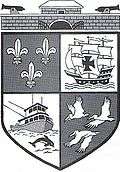
On the top is the historic Ft Gaines with two cannons (one facing North and one facing South) which represents Dauphin Island's part in America's Civil War of the 1860s. The boat is a shrimping vessel which represents the livelihood of many of the residents of the island and the Dolphin is a mammal seen quite often in the Gulf of Mexico and Mobile bay waters surrounding the Island. The birds are Pelicans which are numerous around the island and the entire Gulf coast. The Fleur de Lis represents France (1699–1764). The sailing ship is a Spanish Galleon (1781–1813). Both countries were very influential in settling the area.
Hurricanes
Over the centuries, many hurricanes have struck the island. Some recent storms include:
- In 1979, Hurricane Frederic (September 12, 1979) destroyed the bridge to the mainland, which had been opened in 1955.
- In 1985, Hurricane Elena brought wind gusts of over 130 mph (210 km/h) to the island.
- In 1997, Hurricane Danny caused extensive flooding on the east end of the island.
- In 1998, Hurricane Georges destroyed 41 houses on the island.
- In 2004, Hurricane Ivan caused nearly one-fourth of the island to be covered with approximately two feet of water.
- On August 29, 2005, Hurricane Katrina brought damage to parts of Dauphin Island. Some homes on the west end of the island were destroyed, and the Katrina Cut was formed as a channel splitting off the western part. However, most areas of the Central and East end of the island experienced little flooding from the storm surge. Unlike typical storm surge effects on a mainland coastline and affected waterways, on an island the surge moves around and over the land mass without the mounding up of water experienced on the mainland.
The approach road to the island fared better than expected. The damage to most East End beach front homes was limited to decks, stairs and storage buildings. In DeSoto Landing, a gated gulf-front subdivision on Dauphin Island, the main homes had no water entering the homes unless a window or roof system failed; many avoided surge waters entirely. Damage was limited due to Sand Island (Pelican Island), a large sandbar south of DeSoto Landing which broke the force of battering waves.
An oil drilling platform grounded near the island as the hurricane passed by. It was identified by its owners, Diamond Offshore Drilling Inc., as the Ocean Warwick, pushed nearly 60 miles (97 km) from its original location by the hurricane.
Tourist attractions
The old walled Fort Gaines is on the east end of Dauphin Island. A ferry from nearby Fort Morgan in Gulf Shores brings both vehicles and pedestrians to the island. One of the closest attractions to the ferry dock is The Estuarium, a fresh- and saltwater aquarium highlighting species native to Alabama.
See also
| Wikimedia Commons has media related to Dauphin Island, Alabama. |
Climate
The climate in this area is characterized by hot, humid summers and generally mild to cool winters. According to the Köppen Climate Classification system, Dauphin Island has a humid subtropical climate, abbreviated "Cfa" on climate maps.[13]
| Climate data for Dauphin Island #2, AL, 1981-2010 normals, extremes 1975-present | |||||||||||||
|---|---|---|---|---|---|---|---|---|---|---|---|---|---|
| Month | Jan | Feb | Mar | Apr | May | Jun | Jul | Aug | Sep | Oct | Nov | Dec | Year |
| Record high °F (°C) | 75 (24) |
76 (24) |
80 (27) |
88 (31) |
93 (34) |
96 (36) |
101 (38) |
99 (37) |
95 (35) |
91 (33) |
84 (29) |
81 (27) |
101 (38) |
| Average high °F (°C) | 59.0 (15) |
61.6 (16.4) |
67.4 (19.7) |
74.1 (23.4) |
81.6 (27.6) |
87.0 (30.6) |
89.2 (31.8) |
89.0 (31.7) |
85.8 (29.9) |
77.8 (25.4) |
69.4 (20.8) |
61.6 (16.4) |
75.29 (24.06) |
| Average low °F (°C) | 45.5 (7.5) |
48.4 (9.1) |
55.2 (12.9) |
62.6 (17) |
71.1 (21.7) |
76.1 (24.5) |
77.8 (25.4) |
78.0 (25.6) |
75.0 (23.9) |
66.1 (18.9) |
56.4 (13.6) |
48.3 (9.1) |
63.38 (17.43) |
| Record low °F (°C) | 9 (−13) |
19 (−7) |
23 (−5) |
35 (2) |
50 (10) |
55 (13) |
65 (18) |
64 (18) |
57 (14) |
37 (3) |
24 (−4) |
11 (−12) |
9 (−13) |
| Average precipitation inches (mm) | 5.29 (134.4) |
5.30 (134.6) |
5.31 (134.9) |
4.27 (108.5) |
4.41 (112) |
5.14 (130.6) |
6.23 (158.2) |
7.19 (182.6) |
5.38 (136.7) |
3.85 (97.8) |
4.14 (105.2) |
4.87 (123.7) |
61.38 (1,559.2) |
| Average rainy days (≥ 0.01 in) | 12 | 10 | 9 | 7 | 7 | 10 | 11 | 12 | 9 | 7 | 9 | 12 | 115 |
| Source: | |||||||||||||
References
- ↑ "US Gazetteer files: 2010, 2000, and 1990". United States Census Bureau. 2011-02-12. Retrieved 2011-04-23.
- ↑ "Dauphin Island". Geographic Names Information System. United States Geological Survey. Retrieved 2009-07-26.
- ↑ http://www.encyclopediaofalabama.org/article/h-3360
- ↑ Dauphin Island Fishing Pier. Dauphinisland.org. Retrieved on 2013-07-21.
- ↑ Dauphin Island public beach fee set to begin in late May | al.com. Blog.al.com. Retrieved on 2013-07-21.
- 1 2 "The coinage for Massacre Island, 1699!". Shirepost.com. Retrieved 2007-05-09.
- ↑ "Annual Estimates of the Resident Population for Incorporated Places: April 1, 2010 to July 1, 2015". Retrieved July 2, 2016.
- ↑ "U.S. Decennial Census". Census.gov. Retrieved June 6, 2013.
- ↑ "Annual Estimates of the Resident Population: April 1, 2010 to July 1, 2013". Retrieved June 3, 2014.
- ↑ "American FactFinder". United States Census Bureau. Retrieved 2008-01-31.
- ↑ "American FactFinder". United States Census Bureau. Retrieved 2015-08-04.
- ↑ Records of United States Air Force Commands, Activities, and Organizations U.S. National Archives
- ↑ Climate Summary for Dauphin Island, Alabama
External links
- Town of Dauphin Island, official website
- Dauphin Island Property Owners Association
- Island Mullet Wrapper - Dauphin Island news and information
- Dauphin Island news and information
- Still in Harm's Way, NOW on PBS, Video on Dauphin Island
- Dauphin Island Park and Beach Board Dauphin Island, Alabama
- Dauphin Island Foundation
- Historic Fort Gaines on Dauphin Island, Alabama
Municipalities and communities of Mobile County, Alabama, United States | ||
|---|---|---|
| Cities |  | |
| Towns | ||
| CDPs | ||
| Unincorporated communities | ||
| Ghost town | ||
| Footnotes | ‡This populated place also has portions in an adjacent county or counties | |