San Leonardo, Nueva Ecija
| San Leonardo | ||
|---|---|---|
| Municipality | ||
 | ||
| ||
 Map of Nueva Ecija showing the location of San Leonardo | ||
.svg.png) San Leonardo Location within the Philippines | ||
| Coordinates: 15°22′N 120°58′E / 15.367°N 120.967°ECoordinates: 15°22′N 120°58′E / 15.367°N 120.967°E | ||
| Country | Philippines | |
| Region | Central Luzon (Region III) | |
| Province | Nueva Ecija | |
| District | 4th District | |
| Barangays | 15 | |
| Government[1] | ||
| • Mayor | Froilan A. Nagaño | |
| Area[2] | ||
| • Total | 151.90 km2 (58.65 sq mi) | |
| Population (2010)[3] | ||
| • Total | 58,120 | |
| • Density | 380/km2 (990/sq mi) | |
| Time zone | PST (UTC+8) | |
| ZIP code | 3102 | |
| Dialing code | 44 | |
| Income class | 1st class; partially urban | |

San Leonardo is a first class municipality in the province of Nueva Ecija, Philippines. According to the 2010 census, it has a population of 58,120 people.[3]
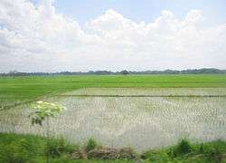
San Leonardo is located between Gapan City and Santa Rosa. It is 103 kilometres (64 mi) from Manila. The area has a farming economy. San Leonardo has vast rice fields and land for growing vegetables and poultry products.
Barangays
San Leonardo is politically subdivided into 15 barangays.[2]
- Bonifacio (Población)
- Burgos (Población)
- Castellano
- Diversion
- Magpapalayoc
- Mallorca
- Mambangnan
- Nieves
- Rizal (Población)
- San Anton
- San Bartolomé (Población)
- San Roque
- Tabuating
- Tagumpay
- Tambo-Adorable
History
During World War II, Japanese Occupation forces entered in San Leonardo, Nueva Ecija on 1942 during the Japanese Invasion and Occupation. Novo Ecijano and Hukbalahap Communist guerrilla resistance groups from 1942 to 1944 in San Leonardo, Nueva Ecija for the sieges and invasions to attacked of the Japanese Imperial forces was found retreated and before the liberation on 1945 from the Allied troops.
On January to April 1945, the joint and combined military force of Filipino soldiers and officers under the Philippine Commonwealth Army and Philippine Constabulary units and the American soldiers and officers under the United States Army units was recaptured and they liberated the town municipality of San Leonardo, Nueva Ecija and they helping to the Novo Ecijano and Hukbalahap Communist resistance groups and defeats against the Japanese soldiers and officers under the Imperial Japanese Armed Forces and the Makapili soldiers and begins the Battle of San Leonardo and the Battle of Gapan between the Japanese and the combined American and Philippine Commonwealth troops on January to April 1945 and ended World War II.
Demographics
| Population census of San Leonardo | ||
|---|---|---|
| Year | Pop. | ±% p.a. |
| 1990 | 39,740 | — |
| 1995 | 46,545 | +3.01% |
| 2000 | 50,478 | +1.75% |
| 2007 | 54,596 | +1.09% |
| 2010 | 58,120 | +2.30% |
| Source: National Statistics Office[3] | ||
Schools
Public elementary schools
- C.I. Villaroman ES (Formerly Magpapalayok Elementary School)
- Castellano Elementary School
- Mallorca Elementary School
- Mambangnan Elementary School
- Nieves Elementary School
- San Anton Elementary School
- San Leonardo Central School
- San Roque Elementary School
- Tagumpay Elementary School
- Tambo North Elementary School
- Tambo South Elementary School
Public high schools
- Magpapalayok National High School
- Mallorca National High School
- Mambangnan High School
- San Anton National High School
Tertiary
- Nueva Ecija University of Science and Technology - San Leonardo Campus
Private schools
- Akarui Technical School Foundation
- Clever Lane Montessori School
- Dr. Gloria D. Lacson Foundation Colleges
- L.F. Gonzales College of Science & Technology, Inc (LFGCSTI)
- Lasaltech Academy
- San Leonardo Academy
- San Lorenzo Ruiz Diocesan Academy
- Seraphin Learning Center
- Trinity Christian School (TCS)
Images
 Town hall
 Municipal covered courts
 St. Bartholomew the Apostle Church
 Public market
 Biggest gymnasium in Nueva Ecija
References
- ↑ "Official City/Municipal 2013 Election Results". Intramuros, Manila, Philippines: Commission on Elections (COMELEC). 11 September 2013. Retrieved 21 October 2013.
- 1 2 "Province: Nueva Ecija". PSGC Interactive. Makati City, Philippines: National Statistical Coordination Board. Retrieved 21 October 2013.
- 1 2 3 "Total Population by Province, City, Municipality and Barangay: as of May 1, 2010" (PDF). 2010 Census of Population and Housing. National Statistics Office. Retrieved 2012-10-22.
External links
| Wikimedia Commons has media related to San Leonardo, Nueva Ecija. |
- The Official Website of San Leonardo, Nueva Ecija
- Pasyalan Nueva Ecija
- Philippine Standard Geographic Code
- Philippine Census Information
- Local Governance Performance Management System
 |
Santa Rosa | | ||
| Jaen | |
Peñaranda | ||
| ||||
| | ||||
| San Isidro | Gapan |
Palayan (capital) | |
| Municipalities | |
| Component cities | |
| Misc. | |