Saint-Cricq-Chalosse
| Saint-Cricq-Chalosse | ||
|---|---|---|
|
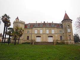
Château | ||
| ||
 Saint-Cricq-Chalosse | ||
|
Location within Nouvelle-Aquitaine region  Saint-Cricq-Chalosse | ||
| Coordinates: 43°39′19″N 0°41′01″W / 43.6553°N 0.6836°WCoordinates: 43°39′19″N 0°41′01″W / 43.6553°N 0.6836°W | ||
| Country | France | |
| Region | Nouvelle-Aquitaine | |
| Department | Landes | |
| Arrondissement | Mont-de-Marsan | |
| Canton | Hagetmau | |
| Intercommunality | Hagetmau Communes Unies | |
| Government | ||
| • Mayor (2014–2020) | Aimée Laborde | |
| Area1 | 20.23 km2 (7.81 sq mi) | |
| Population (2013)2 | 633 | |
| • Density | 31/km2 (81/sq mi) | |
| Time zone | CET (UTC+1) | |
| • Summer (DST) | CEST (UTC+2) | |
| INSEE/Postal code | 40253 / 40700 | |
| Elevation |
50–128 m (164–420 ft) (avg. 90 m or 300 ft) | |
|
1 French Land Register data, which excludes lakes, ponds, glaciers > 1 km² (0.386 sq mi or 247 acres) and river estuaries. 2 Population without double counting: residents of multiple communes (e.g., students and military personnel) only counted once. | ||
.svg.png)
Saint-Cricq-Chalosse is a commune in the Landes department in Nouvelle-Aquitaine in southwestern France.
Population
| Historical population | ||
|---|---|---|
| Year | Pop. | ±% |
| 1793 | 430 | — |
| 1806 | 442 | +2.8% |
| 1821 | 1,110 | +151.1% |
| 1831 | 1,142 | +2.9% |
| 1841 | 1,119 | −2.0% |
| 1851 | 1,061 | −5.2% |
| 1861 | 1,068 | +0.7% |
| 1872 | 955 | −10.6% |
| 1881 | 983 | +2.9% |
| 1891 | 944 | −4.0% |
| 1901 | 920 | −2.5% |
| 1911 | 926 | +0.7% |
| 1921 | 872 | −5.8% |
| 1931 | 784 | −10.1% |
| 1946 | 703 | −10.3% |
| 1954 | 678 | −3.6% |
| 1962 | 609 | −10.2% |
| 1968 | 576 | −5.4% |
| 1975 | 574 | −0.3% |
| 1982 | 568 | −1.0% |
| 1990 | 585 | +3.0% |
| 1999 | 561 | −4.1% |
| 2008 | 620 | +10.5% |
| 2013 | 633 | +2.1% |
See also
References
| Wikimedia Commons has media related to Saint-Cricq-Chalosse. |
This article is issued from Wikipedia - version of the 11/10/2016. The text is available under the Creative Commons Attribution/Share Alike but additional terms may apply for the media files.