Moliets-et-Maa
| Moliets-et-Maa | ||
|---|---|---|
|
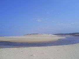
The beach at Moliets-et-Mâa | ||
| ||
 Moliets-et-Maa | ||
|
Location within Nouvelle-Aquitaine region  Moliets-et-Maa | ||
| Coordinates: 43°51′00″N 1°21′25″W / 43.85°N 1.3569°WCoordinates: 43°51′00″N 1°21′25″W / 43.85°N 1.3569°W | ||
| Country | France | |
| Region | Nouvelle-Aquitaine | |
| Department | Landes | |
| Arrondissement | Dax | |
| Canton | Soustons | |
| Intercommunality | Maremne-Adour-Côte-Sud | |
| Government | ||
| • Mayor (2001–2008) | Anne-Marie Cancouët | |
| Area1 | 27.66 km2 (10.68 sq mi) | |
| Population (2007)2 | 809 | |
| • Density | 29/km2 (76/sq mi) | |
| Time zone | CET (UTC+1) | |
| • Summer (DST) | CEST (UTC+2) | |
| INSEE/Postal code | 40187 / 40660 | |
| Elevation |
0–55 m (0–180 ft) (avg. 26 m or 85 ft) | |
|
1 French Land Register data, which excludes lakes, ponds, glaciers > 1 km² (0.386 sq mi or 247 acres) and river estuaries. 2 Population without double counting: residents of multiple communes (e.g., students and military personnel) only counted once. | ||
.svg.png)
Moliets-et-Maa is a commune in the Landes department in Nouvelle-Aquitaine in south-western France.
Description
The principal economic activity is tourism and the village features long sandy beaches and golf courses.
The village proper and the beach area are around 2 km (1.2 mi) apart, a common feature of towns and villages in this region of France known as the Côte d'Argent. The "courant d'Huchet" flows into the Atlantic Ocean on the Moliets's beach.
See also
External links
| Wikimedia Commons has media related to Moliets-et-Maâ. |
This article is issued from Wikipedia - version of the 11/10/2016. The text is available under the Creative Commons Attribution/Share Alike but additional terms may apply for the media files.