Rush City, Minnesota
| Rush City, Minnesota | |
|---|---|
| City | |
|
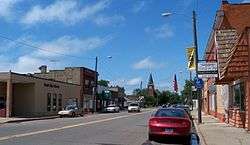
Downtown Rush City | |
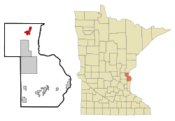 Location of Rush City within Chisago County, Minnesota | |
| Coordinates: 45°41′7″N 92°58′7″W / 45.68528°N 92.96861°W | |
| Country | United States |
| State | Minnesota |
| County | Chisago |
| Government | |
| • Mayor | Dan Dahlberg |
| Area[1] | |
| • Total | 4.32 sq mi (11.19 km2) |
| • Land | 4.25 sq mi (11.01 km2) |
| • Water | 0.07 sq mi (0.18 km2) |
| Elevation | 915 ft (279 m) |
| Population (2010)[2] | |
| • Total | 3,079 |
| • Estimate (2012[3]) | 3,065 |
| • Density | 724.5/sq mi (279.7/km2) |
| Time zone | Central (CST) (UTC-6) |
| • Summer (DST) | CDT (UTC-5) |
| ZIP code | 55069 |
| Area code(s) | 320 |
| FIPS code | 27-56266[4] |
| GNIS feature ID | 0650391[5] |
| Website | www.rushcitymn.us |
Rush City is a city in Chisago County, Minnesota, United States. The population was 3,079 at the 2010 census.[6] It is sixty-three miles north of Minneapolis–Saint Paul.
History
Rush City was platted in 1870, and incorporated in 1874.[7]
Geography
According to the United States Census Bureau, the city has a total area of 4.32 square miles (11.19 km2), of which, 4.25 square miles (11.01 km2) is land and 0.07 square miles (0.18 km2) is water.[1]
Rush City is the location for a state prison that houses just under 1000 male inmates. The facility was opened in February 2000, is the newest state prison in Minnesota, and employs about 350 people.[8]
Transportation
Interstate 35 serves as a main route for the community. Other main routes include Minnesota State Highway 361. Rush City is served by the Rush City Regional Airport.
Demographics
| Historical population | |||
|---|---|---|---|
| Census | Pop. | %± | |
| 1880 | 580 | — | |
| 1890 | 707 | 21.9% | |
| 1900 | 987 | 39.6% | |
| 1910 | 964 | −2.3% | |
| 1920 | 971 | 0.7% | |
| 1930 | 908 | −6.5% | |
| 1940 | 1,020 | 12.3% | |
| 1950 | 1,175 | 15.2% | |
| 1960 | 1,108 | −5.7% | |
| 1970 | 1,130 | 2.0% | |
| 1980 | 1,198 | 6.0% | |
| 1990 | 1,497 | 25.0% | |
| 2000 | 2,112 | 41.1% | |
| 2010 | 3,079 | 45.8% | |
| Est. 2015 | 3,072 | [9] | −0.2% |
| U.S. Decennial Census | |||
2010 census
As of the census[2] of 2010, there were 3,079 people, 844 households, and 524 families residing in the city. The population density was 724.5 inhabitants per square mile (279.7/km2). There were 908 housing units at an average density of 213.6 per square mile (82.5/km2). The racial makeup of the city was 80.5% White, 13.2% African American, 4.0% Native American, 1.3% Asian, 0.1% from other races, and 0.8% from two or more races. Hispanic or Latino of any race were 2.5% of the population.
There were 844 households of which 35.1% had children under the age of 18 living with them, 40.8% were married couples living together, 15.8% had a female householder with no husband present, 5.6% had a male householder with no wife present, and 37.9% were non-families. 30.7% of all households were made up of individuals and 12.8% had someone living alone who was 65 years of age or older. The average household size was 2.43 and the average family size was 3.01.
The median age in the city was 33.6 years. 17.8% of residents were under the age of 18; 12.3% were between the ages of 18 and 24; 37.9% were from 25 to 44; 21.8% were from 45 to 64; and 10.1% were 65 years of age or older. The gender makeup of the city was 64.9% male and 35.1% female.
2000 census
As of the census[4] of 2000, there were 2,112 people, 705 households, and 461 families residing in the city. The population density was 689.6 people per square mile (266.1/km²). There were 724 housing units at an average density of 237.5 per square mile (91.7/km²). The racial makeup of the city was 90.10% White, 4.66% African American, 1.33% Native American, 1.24% Asian, 0.05% Pacific Islander, 1.24% from other races, and 1.38% from two or more races. Hispanic or Latino of any race were 3.04% of the population.
There were 705 households out of which 39.4% had children under the age of 18 living with them, 45.0% were married couples living together, 14.9% had a female householder with no husband present, and 34.5% were non-families. 28.5% of all households were made up of individuals and 13.5% had someone living alone who was 65 years of age or older. The average household size was 2.54 and the average family size was 3.06.
In the city the population was spread out with 26.3% under the age of 18, 11.9% from 18 to 24, 33.9% from 25 to 44, 14.2% from 45 to 64, and 13.7% who were 65 years of age or older. The median age was 32 years. For every 100 females there were 120.6 males. For every 100 females age 18 and over, there were 120.5 males.
The median income for a household in the city was $41,466, and the median income for a family was $40,380. Males had a median income of $31,750 versus $21,813 for females. The per capita income for the city was $14,668. About 10.2% of families and 11.6% of the population were below the poverty line, including 16.6% of those under age 18 and 10.6% of those age 65 or over.
Notable people
- Ruth Duccini – (1918–2014), actress, munchkin in The Wizard of Oz. Born in Rush City.
- Clayton Tonnemaker – (1928–1996), former American football player, who played center and linebacker for the Green Bay Packers from 1950 to 1954, also played center linebacker at University of Minnesota. Tonnemaker lettered in football at Rush City High School as an 8th grader.
- David Madson - (1964-1997), architect and former lover of Andrew Cunanan, the serial killer. David's body was found on the east shore of Rush Lake near an abandoned farm on May 3, 1997. He had been killed by Cunanan during a murder spree taking place from April through July 1997. David Madson attended the University of Minnesota-Duluth and later earned a master's degree in architecture from the university's main campus in Minneapolis and he won the President's Award for a traveling exhibit on AIDS. In 1994 he was a guest lecturer on assisted living for people with AIDS at Harvard.
References
- 1 2 "US Gazetteer files 2010". United States Census Bureau. Retrieved 2012-11-13.
- 1 2 "American FactFinder". United States Census Bureau. Retrieved 2012-11-13.
- ↑ "Population Estimates". United States Census Bureau. Retrieved 2013-05-28.
- 1 2 "American FactFinder". United States Census Bureau. Retrieved 2008-01-31.
- ↑ "US Board on Geographic Names". United States Geological Survey. 2007-10-25. Retrieved 2008-01-31.
- ↑ "2010 Census Redistricting Data (Public Law 94-171) Summary File". American FactFinder. U.S. Census Bureau, 2010 Census. Retrieved 23 April 2011.
- ↑ Upham, Warren (1920). Minnesota Geographic Names: Their Origin and Historic Significance. Minnesota Historical Society. p. 109.
- ↑ http://www.chisagocountypress.com/main.asp?SectionID=1&SubSectionID=1&ArticleID=13638
- ↑ "Annual Estimates of the Resident Population for Incorporated Places: April 1, 2010 to July 1, 2015". Retrieved July 2, 2016.
External links
| Wikimedia Commons has media related to Rush City, Minnesota. |
- Rush City Area Chamber of Commerce
- Rush City School District – Independent School District #139
- Rush City Regional Airport
- Minnesota Correctional Facility–Rush City
Municipalities and communities of Chisago County, Minnesota, United States | ||
|---|---|---|
| Cities | 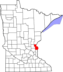 | |
| Townships | ||
| Unincorporated communities | ||
Coordinates: 45°41′08″N 92°57′56″W / 45.68556°N 92.96556°W