Center City, Minnesota
| Center City, Minnesota | |
|---|---|
| City | |
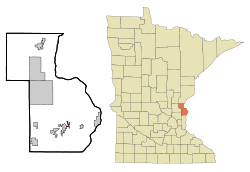 Location of Center City within Chisago County, Minnesota | |
| Coordinates: 45°23′42″N 92°49′2″W / 45.39500°N 92.81722°WCoordinates: 45°23′42″N 92°49′2″W / 45.39500°N 92.81722°W | |
| Country | United States |
| State | Minnesota |
| County | Chisago |
| Area[1] | |
| • Total | 0.61 sq mi (1.58 km2) |
| • Land | 0.59 sq mi (1.53 km2) |
| • Water | 0.02 sq mi (0.05 km2) |
| Elevation | 928 ft (283 m) |
| Population (2010)[2] | |
| • Total | 628 |
| • Estimate (2012[3]) | 626 |
| • Density | 1,064.4/sq mi (411.0/km2) |
| Time zone | Central (CST) (UTC-6) |
| • Summer (DST) | CDT (UTC-5) |
| ZIP codes | 55002, 55012 |
| Area code(s) | 651 |
| FIPS code | 27-10576[4] |
| GNIS feature ID | 0641045[5] |
| Website | http://www.centercitymn.us/ |
Center City is a city in Chisago County, Minnesota, United States. The population was 628 at the 2010 census.[6] It is the county seat of Chisago County.[7]
U.S. Highway 8 serves as a main route for the community.
History
Center City was platted in 1857, and named from its location near the geographic center.[8] A post office was established as Centre City in 1858, and the name was changed to Center City in 1893.[9]
Geography
According to the United States Census Bureau, the city has a total area of 0.61 square miles (1.58 km2), of which, 0.59 square miles (1.53 km2) is land and 0.02 square miles (0.05 km2) is water.[1]
Nearby places include Lindstrom, Shafer, Taylors Falls, St. Croix Falls, Chisago City, Stacy, Wyoming, North Branch, and Forest Lake.
Demographics
| Historical population | |||
|---|---|---|---|
| Census | Pop. | %± | |
| 1880 | 33 | — | |
| 1910 | 252 | — | |
| 1920 | 285 | 13.1% | |
| 1930 | 285 | 0.0% | |
| 1940 | 251 | −11.9% | |
| 1950 | 311 | 23.9% | |
| 1960 | 293 | −5.8% | |
| 1970 | 324 | 10.6% | |
| 1980 | 458 | 41.4% | |
| 1990 | 451 | −1.5% | |
| 2000 | 582 | 29.0% | |
| 2010 | 628 | 7.9% | |
| Est. 2015 | 628 | [10] | 0.0% |
| U.S. Decennial Census | |||
2010 census
As of the census[2] of 2010, there were 628 people, 247 households, and 175 families residing in the city. The population density was 1,064.4 inhabitants per square mile (411.0/km2). There were 291 housing units at an average density of 493.2 per square mile (190.4/km2). The racial makeup of the city was 97.8% White, 0.5% African American, 0.6% Native American, 0.3% Asian, 0.2% from other races, and 0.6% from two or more races. Hispanic or Latino of any race were 1.1% of the population.
There were 247 households of which 27.9% had children under the age of 18 living with them, 59.1% were married couples living together, 8.9% had a female householder with no husband present, 2.8% had a male householder with no wife present, and 29.1% were non-families. 26.3% of all households were made up of individuals and 10.5% had someone living alone who was 65 years of age or older. The average household size was 2.38 and the average family size was 2.81.
The median age in the city was 44.7 years. 19.6% of residents were under the age of 18; 8.1% were between the ages of 18 and 24; 23.1% were from 25 to 44; 31.4% were from 45 to 64; and 17.8% were 65 years of age or older. The gender makeup of the city was 50.3% male and 49.7% female.
2000 census
As of the census[4] of 2000, there were 582 people, 194 households, and 148 families residing in the city. The population density was 1,240.8 people per square mile (478.1/km²). There were 214 housing units at an average density of 456.3 per square mile (175.8/km²). The racial makeup of the city was 96.91% White, 0.69% African American, 2.06% Native American, 0.17% Asian, and 0.17% from two or more races. Hispanic or Latino of any race were 0.69% of the population.
There were 194 households out of which 33.5% had children under the age of 18 living with them, 66.5% were married couples living together, 7.7% had a female householder with no husband present, and 23.7% were non-families. 18.0% of all households were made up of individuals and 5.2% had someone living alone who was 65 years of age or older. The average household size was 2.65 and the average family size was 3.00.
In the city the population was spread out with 24.6% under the age of 18, 7.4% from 18 to 24, 30.6% from 25 to 44, 25.6% from 45 to 64, and 11.9% who were 65 years of age or older. The median age was 39 years. For every 100 females there were 112.4 males. For every 100 females age 18 and over, there were 120.6 males.
The median income for a household in the city was $48,594, and the median income for a family was $51,875. Males had a median income of $39,205 versus $30,156 for females. The per capita income for the city was $17,774. About 0.7% of families and 5.5% of the population were below the poverty line, including 1.3% of those under age 18 and 2.2% of those age 65 or over.
Economy
The Hazelden drug and alcohol treatment center is located in Center City.
See also
References
- 1 2 "US Gazetteer files 2010". United States Census Bureau. Archived from the original on 2012-01-24. Retrieved 2012-11-13.
- 1 2 "American FactFinder". United States Census Bureau. Retrieved 2012-11-13.
- ↑ "Population Estimates". United States Census Bureau. Archived from the original on 2013-06-17. Retrieved 2013-05-28.
- 1 2 "American FactFinder". United States Census Bureau. Archived from the original on 2013-09-11. Retrieved 2008-01-31.
- ↑ "US Board on Geographic Names". United States Geological Survey. 2007-10-25. Retrieved 2008-01-31.
- ↑ "2010 Census Redistricting Data (Public Law 94-171) Summary File". American FactFinder. U.S. Census Bureau, 2010 Census. Archived from the original on 21 July 2011. Retrieved 23 April 2011.
- ↑ "Find a County". National Association of Counties. Archived from the original on 2011-05-31. Retrieved 2011-06-07.
- ↑ Upham, Warren (1920). Minnesota Geographic Names: Their Origin and Historic Significance. Minnesota Historical Society. p. 108.
- ↑ "Chisago County". Jim Forte Postal History. Retrieved 19 April 2015.
- ↑ "Annual Estimates of the Resident Population for Incorporated Places: April 1, 2010 to July 1, 2015". Retrieved July 2, 2016.
External links
Municipalities and communities of Chisago County, Minnesota, United States | ||
|---|---|---|
| Cities | 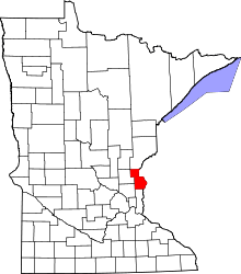 | |
| Townships | ||
| Unincorporated communities | ||