Rockland, Maine
| Rockland, Maine | ||
|---|---|---|
| City | ||
|
Rockland Downtown | ||
| ||
| Nickname(s): Vacationland | ||
| Motto: God Gives a Reward to Industry | ||
 Location in Knox County and the state of Maine. | ||
 Rockland, Maine Location in the United States | ||
| Coordinates: 44°6′34″N 69°6′53″W / 44.10944°N 69.11472°WCoordinates: 44°6′34″N 69°6′53″W / 44.10944°N 69.11472°W | ||
| Country | United States | |
| State | Maine | |
| County | Knox | |
| Incorporated (town) | July 28, 1848 | |
| Incorporated (city) | 1854 | |
| Government | ||
| • Mayor | Frank C. Isganitis | |
| Area[1] | ||
| • Total | 15.07 sq mi (39.03 km2) | |
| • Land | 12.84 sq mi (33.26 km2) | |
| • Water | 2.23 sq mi (5.78 km2) | |
| Elevation | 23 ft (7 m) | |
| Population (2010)[2] | ||
| • Total | 7,297 | |
| • Estimate (2012[3]) | 7,225 | |
| • Density | 568.3/sq mi (219.4/km2) | |
| Time zone | Eastern (EST) (UTC-5) | |
| • Summer (DST) | EDT (UTC-4) | |
| ZIP code | 04841 | |
| Area code(s) | 207 | |
| FIPS code | 23-63590 | |
| GNIS feature ID | 0574358 | |


Rockland is a town in Knox County, Maine, in the United States. As of the 2010 census, the city population was 7,297. It is the county seat of Knox County.[4] The city is a popular tourist destination. It is a departure point for the Maine State Ferry Service to the islands of Penobscot Bay: Vinalhaven, North Haven and Matinicus.
History
Abenaki Indians called it Catawamteak, meaning "great landing place." In 1767, John Lermond and his two brothers from Warren built a camp to produce oak staves and pine lumber. Thereafter known as Lermond's Cove, it was first settled about 1769. When in 1777 Thomaston was incorporated, Lermond's Cove became a district called Shore village. On July 28, 1848, it was set off as the town of East Thomaston. Renamed Rockland in 1850, it was chartered as a city in 1854.[5]


Rockland developed rapidly because of shipbuilding and lime production. In 1854 alone, the city built eleven ships, three barks, six brigs and four schooners. The city had twelve lime quarries and 125 lime kilns, with upwards of 300 vessels to transport the mineral to various ports in the country. [6]
By 1886, shipbuilding was surpassed by the lime business, which had twelve manufacturers employing 1,000 workers. Nevertheless, Rockland had three or more shipyards, a marine railway, five sail lofts and two boatbuilders. Other industries included three grain mills, two foundries, three carriage factories, six lumber mills, two machine shops, three cooperies, one tannery, four granite and marble works, two boot and shoe factories, and four printing offices. Fishing was also important. Fleets of Friendship Sloops sailed between the harbor and fishing grounds across Penobscot Bay.[7]
The opening of the Knox and Lincoln Railroad in 1871 brought an influx of tourists. Inns and hotels were established to accommodate them, with the grandest being The Bay Point Hotel in 1889. With a commanding view near the breakwater, the resort offered every luxury and amusement. Renamed The Samoset Hotel in 1902, it was successful until the Great Depression, which began a slow decline. In the age of automobiles, travelers were no longer restricted to the limits of train service, but were free to explore elsewhere. Closed in 1969, the Victorian hotel burned in 1972. A new Samoset Resort opened in 1974.[8]
In 1915, the new superdreadnought USS Nevada (BB-36) conducted tests and completed her running trials just off the shore from Rockland.[9][10]
Today, Rockland is an officially designated micropolitan area. Since the early 1990s, Rockland has seen a shift in its economy away from the fishery and toward a service center city. It has also seen a substantial increase in tourism and the downtown has transformed into one of unique shops, boutiques, fine dining and art galleries. Rockland is the commercial center of the midcoast Maine region, with many historic inns, a coffee roaster, a food co-op, a community radio station WRFR-LP, and the Farnsworth Art Museum. Rockland was named a Coast Guard City in March 2008, in recognition of the long-standing and special relationship that the city and its residents have with the United States Coast Guard.[11][12][13]
 General view c. 1908
 Tillson's Wharf c. 1908
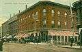 Main Street in 1915
 Rockland station, ca. 1910
Attractions
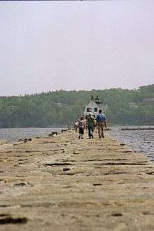
Rockland is home to the Maine Lobster Festival, a celebration held annually in honor of the town's primary export: lobster. In the first week of August, thousands of people come from all over the world to participate in this five-day event.[14] Rockland also is home to the Farnsworth Art Museum, a world-famous art gallery containing paintings by Andrew Wyeth and other well-known New England artists. Rockland's main street also features numerous small shops and businesses including coffee shops, book stores, art supply stores, restaurants, organic markets, computer repair and toy stores. Penobscot Bay, which Rockland borders, is known internationally as one of the best recreational sailing grounds in the world. The city's breakwater, built in the 19th century, also draws tourists. Also the Maine Eastern Railroad is based in Rockland and offers limited seasonal passenger train excursions starting in Brunswick, running to Rockland and back.
Geography

Rockland is located at 44°6′34″N 69°6′53″W / 44.10944°N 69.11472°W (44.109569, -69.114652).[15]
According to the United States Census Bureau, the city has a total area of 15.07 square miles (39.03 km2), of which 12.84 square miles (33.26 km2) is land and 2.23 square miles (5.78 km2) is water.[1] Rockland is located on Penobscot Bay and the Gulf of Maine, part of the Atlantic Ocean. About ten miles to the east are the islands of North Haven and Vinalhaven, reached by ferry from Rockland.
Rockland is crossed by U.S. 1 and 1A, and state routes 17, 73 and 90. It borders the towns of Owls Head to the southeast, Thomaston to the southwest, Warren to the northwest, and Rockport to the northeast.
Climate
| Climate data for Rockland, Maine | |||||||||||||
|---|---|---|---|---|---|---|---|---|---|---|---|---|---|
| Month | Jan | Feb | Mar | Apr | May | Jun | Jul | Aug | Sep | Oct | Nov | Dec | Year |
| Record high °F (°C) | 58 (14) |
61 (16) |
74 (23) |
80 (27) |
95 (35) |
94 (34) |
96 (36) |
93 (34) |
90 (32) |
82 (28) |
74 (23) |
63 (17) |
96 (36) |
| Average high °F (°C) | 30 (−1) |
33 (1) |
40 (4) |
52 (11) |
62 (17) |
71 (22) |
76 (24) |
76 (24) |
68 (20) |
57 (14) |
47 (8) |
36 (2) |
54 (12.2) |
| Daily mean °F (°C) | 20 (−7) |
24 (−4) |
31 (−1) |
43 (6) |
53 (12) |
62 (17) |
68 (20) |
67 (19) |
59 (15) |
48 (9) |
39 (4) |
27 (−3) |
45.1 (7.3) |
| Average low °F (°C) | 10 (−12) |
14 (−10) |
22 (−6) |
33 (1) |
43 (6) |
53 (12) |
59 (15) |
58 (14) |
50 (10) |
39 (4) |
30 (−1) |
18 (−8) |
35.8 (2.1) |
| Record low °F (°C) | −22 (−30) |
−20 (−29) |
−11 (−24) |
10 (−12) |
21 (−6) |
30 (−1) |
43 (6) |
37 (3) |
28 (−2) |
19 (−7) |
4 (−16) |
−25 (−32) |
−25 (−32) |
| Average precipitation inches (mm) | 4.26 (108.2) |
4.00 (101.6) |
4.80 (121.9) |
5.02 (127.5) |
4.14 (105.2) |
4.06 (103.1) |
3.43 (87.1) |
3.28 (83.3) |
4.51 (114.6) |
5.14 (130.6) |
5.71 (145) |
4.99 (126.7) |
53.34 (1,354.8) |
| Source: weather.com[16] | |||||||||||||
Demographics

| Historical population | |||
|---|---|---|---|
| Census | Pop. | %± | |
| 1850 | 5,052 | — | |
| 1860 | 7,316 | 44.8% | |
| 1870 | 7,074 | −3.3% | |
| 1880 | 7,599 | 7.4% | |
| 1890 | 8,174 | 7.6% | |
| 1900 | 8,150 | −0.3% | |
| 1910 | 8,174 | 0.3% | |
| 1920 | 8,100 | −0.9% | |
| 1930 | 9,075 | 12.0% | |
| 1940 | 8,899 | −1.9% | |
| 1950 | 9,284 | 4.3% | |
| 1960 | 8,769 | −5.5% | |
| 1970 | 8,505 | −3.0% | |
| 1980 | 7,919 | −6.9% | |
| 1990 | 7,972 | 0.7% | |
| 2000 | 7,609 | −4.6% | |
| 2010 | 7,297 | −4.1% | |
| Est. 2015 | 7,237 | [17] | −0.8% |
| U.S. Decennial Census | |||
2010 census
As of the census[2] of 2010, there were 7,297 people, 3,423 households, and 1,744 families residing in the city. The population density was 568.3 inhabitants per square mile (219.4/km2). There were 3,925 housing units at an average density of 305.7 per square mile (118.0/km2). The racial makeup of the city was 95.8% White, 0.6% African American, 0.4% Native American, 0.7% Asian, 0.1% Pacific Islander, 0.2% from other races, and 2.2% from two or more races. Hispanic or Latino of any race were 1.3% of the population.
There were 3,423 households of which 23.1% had children under the age of 18 living with them, 34.2% were married couples living together, 12.6% had a female householder with no husband present, 4.2% had a male householder with no wife present, and 49.1% were non-families. 40.0% of all households were made up of individuals and 17.4% had someone living alone who was 65 years of age or older. The average household size was 2.06 and the average family size was 2.73.
The median age in the city was 43.5 years. 18.3% of residents were under the age of 18; 8.7% were between the ages of 18 and 24; 24.8% were from 25 to 44; 28.5% were from 45 to 64; and 19.7% were 65 years of age or older. The gender makeup of the city was 46.5% male and 53.5% female.
2000 census
As of the census[18] of 2000, there were 7,609 people, 3,434 households, and 1,943 families residing in the city. The population density was 589.2 people per square mile (227.6/km²). There were 3,752 housing units at an average density of 290.5 per square mile (112.2/km²). The racial makeup of the city was 97.90% White, 0.25% African American, 0.24% Native American, 0.57% Asian, 0.03% Pacific Islander, 0.11% from other races, and 0.92% from two or more races. Hispanic or Latino of any race were 0.57% of the population.
There were 3,434 households out of which 25.2% had children under the age of 18 living with them, 40.4% were married couples living together, 12.9% had a female householder with no husband present, and 43.4% were non-families. 36.3% of all households were made up of individuals and 16.2% had someone living alone who was 65 years of age or older. The average household size was 2.15 and the average family size was 2.78.
In the city the population was spread out with 21.1% under the age of 18, 8.2% from 18 to 24, 27.3% from 25 to 44, 23.8% from 45 to 64, and 19.5% who were 65 years of age or older. The median age was 41 years. For every 100 females there were 85.6 males. For every 100 females age 18 and over, there were 83.1 males.
The median income for a household in the city was $30,209, and the median income for a family was $37,083. Males had a median income of $27,212 versus $20,708 for females. The per capita income for the city was $16,659. About 10.4% of families and 14.7% of the population were below the poverty line, including 22.2% of those under age 18 and 8.2% of those age 65 or over.
Voter registration
| Voter Registration and Party Enrollment as of November 2012[19] | |||||
|---|---|---|---|---|---|
| Party | Total Voters | Percentage | |||
| Unenrolled | 1,732 | 36.02% | |||
| Democratic | 1,576 | 32.77% | |||
| Republican | 1,294 | 26.91% | |||
| Green Independent | 206 | 4.28% | |||
| Total | 4,808 | 100% | |||
Education
- Oceanside High School-East
- Midcoast S.T.E.A.M. Microschool (K through 5th)
- The Watershed School
- The Apprenticeshop
- Coastal Senior College
- Mid-Coast School of Technology
- Penobscot School
- University College at Rockland
Sites of interest

- Rockland Public Library
- Farnsworth Art Museum
- Lincoln Street Center for Arts & Education
- Maine Lighthouse Museum
- Maine Eastern Railroad
- Maine Lobster Festival
- North Atlantic Blues Festival
- Rockland Breakwater Light
- Rockland Historical Society & Museum
- Maine Boats, Homes, and Harbors Show
- University College at Rockland
- The Coastal Children's Museum
Notable people
- Adelbert Ames, Civil War general, senator and the 27th governor of Mississippi
- Hiram George Berry, Civil War general and first commander of 4th Maine Volunteer Infantry Regiment
- Edwin L. Brown, master penman, designer, engrosser, illustrator; co-founder of Howard & Brown engrossing studio in Rockland.
- William T. Cobb, 46th governor of Maine
- Samuel Collins, Jr., State Senator and Associate Justice on the Maine Supreme Judicial Court
- Leo Connellan, poet
- Maxine Elliott, actress
- David F. Emery, US congressman
- Nathan A. Farwell, US senator
- Samuel C. Fessenden, served in the 37th U. S. Congress, lived and served as a judge in Rockland.[20]
- Todd Field, Academy Award nominated filmmaker[21]
- Obadiah Gardner, US senator
- Henry A. Howard, founder of Rockland Commercial College; teacher of penmanship; co-founder of Howard & Brown engrossing studio in Rockland.
- Edward Sturgis Ingraham, educator, publisher, mountaineer, learned printing trade in Rockland
- Isaac Smith Kalloch, mayor of San Francisco
- Charles E. Littlefield, US congressman
- Theodore E. Long, former President of Elizabethtown College
- Herbert Lord, director of the United States Bureau of the Budget and awarded the Distinguished Service Medal, born in Rockland
- Samizu Matsuki, artist and educator
- Edward Mazurek, State Senator
- Edna St. Vincent Millay, Pulitzer Prize–winning poet
- Louise Nevelson, artist, emigrated from Russia to Rockland as a child
- Edward Lawry Norton, electrical engineer who developed the Norton equivalent circuit, born in Rockland
- Walter Piston, Pulitzer Prize–winning composer
- Robert B. Rheault, former commander of all Special Forces in Vietnam.
- James Breckenridge Speed, businessman and philanthropist, summered and died in Rockland
- Dolly Stewart, Miss Maine (1937)
References
- 1 2 "US Gazetteer files 2010". United States Census Bureau. Retrieved 2012-11-23.
- 1 2 "American FactFinder". United States Census Bureau. Retrieved 2012-11-23.
- ↑ "Population Estimates". United States Census Bureau. Retrieved 2013-07-05.
- ↑ "Find a County". National Association of Counties. Retrieved 2011-06-07.
- ↑ Maine League of Historical Societies and Museums (1970). Doris A. Isaacson, ed. Maine: A Guide 'Down East'. Rockland, Me: Courier-Gazette, Inc. pp. 261–262.
- ↑ Coolidge, Austin J.; John B. Mansfield (1859). A History and Description of New England. Boston, Massachusetts. pp. 284–285.
- ↑ Varney, George J. (1886). "Gazetteer of the state of Maine. Rockland". Boston: Russell
- ↑ "Samoset Resort History". Retrieved 2010-05-09.
- ↑ "Mightiest U.S. Ship Coming" (PDF). The New York Times: 9. September 19, 1915.
- ↑ "Nevada Meets Tests; New Superdreadnought easily fills contract requirements" (PDF). The New York Times: 6. November 8, 1915.
- ↑ "Rockland Coast Guard City, Rockland, Maine, One of 9 USA Coast Guard Cities". Retrieved 2010-05-09.
- ↑ Robicheau, Leanne M. (July 5, 2006). Bangor Daily News https://news.google.com/newspapers?nid=2457&dat=20060705&id=dwU1AAAAIBAJ&sjid=OU8KAAAAIBAJ&pg=1463,1049057. Retrieved 2010-05-09. Missing or empty
|title=(help) - ↑ "Coast Guard City Designation for Rockland, Maine". Retrieved 2010-05-09.
- ↑ "66th Annual Celebration of All Things Lobster, July 31 - August 4, 2013 in Rockland, Maine". Maine Lobster Festival. August 5, 2012. Retrieved October 18, 2012.
- ↑ "US Gazetteer files: 2010, 2000, and 1990". United States Census Bureau. 2011-02-12. Retrieved 2011-04-23.
- ↑ "Monthly Averages for Rockland, Maine". Weather.com. The Weather Channel. Retrieved August 15, 2013.
- ↑ "Annual Estimates of the Resident Population for Incorporated Places: April 1, 2010 to July 1, 2015". Retrieved July 2, 2016.
- ↑ "American FactFinder". United States Census Bureau. Retrieved 2008-01-31.
- ↑ "Registration and Party Enrollment Statistics as of November 6, 2012" (PDF). Maine Bureau of Corporations.
- ↑ Treese, Joel D.. Biographical directory of the American Congress, 1774-1996: the Continental Congress, September 5, 1774, to October 21, 1788, and the Congress of the United States, from the First through the 104th Congress, March 4, 1789, to January 3, 1997. Alexandria, Va.: CQ Staff Directories, Inc., 1997. Print.
- ↑ Gale, Thomas (December 16, 2007). "Todd Field Biography". Contemporary Authors.
External links
| Wikimedia Commons has media related to Rockland, Maine. |
| Wikivoyage has a travel guide for Rockland, Maine. |
- City of Rockland, Maine
- Rockland Public Library
- Maine Eastern Railroad
- Maine Genealogy: Rockland, Knox County, Maine
- The Rockland Maine Song
Municipalities and communities of Knox County, Maine, United States | ||
|---|---|---|
| City | 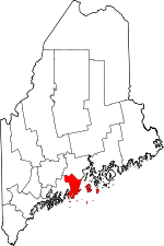 | |
| Towns | ||
| Plantation | ||
| Unorganized territory | ||
| CDPs | ||
| Other villages | ||
Augusta (capital) | |
| Topics |
|
| Society |
|
| Regions | |
| Counties | |
| Cities | |
| Largest towns | |