Westbrook, Maine
| Westbrook, Maine | ||
|---|---|---|
| City | ||
|
Presumpscot River, looking upstream towards One Riverfront Plaza and Saccarappa Falls | ||
| ||
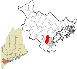 Location in Cumberland County and the state of Maine. | ||
 Westbrook, Maine Location in the United States | ||
| Coordinates: 43°41′7″N 70°21′26″W / 43.68528°N 70.35722°WCoordinates: 43°41′7″N 70°21′26″W / 43.68528°N 70.35722°W | ||
| Country | United States | |
| State | Maine | |
| County | Cumberland | |
| Incorporated | 1814 | |
| Government | ||
| • Mayor | Colleen Hilton | |
| Area[1] | ||
| • Total | 17.33 sq mi (44.88 km2) | |
| • Land | 17.12 sq mi (44.34 km2) | |
| • Water | 0.21 sq mi (0.54 km2) | |
| Elevation | 75 ft (23 m) | |
| Population (2010)[2] | ||
| • Total | 17,494 | |
| • Estimate (2012[3]) | 17,606 | |
| • Density | 1,021.8/sq mi (394.5/km2) | |
| Time zone | Eastern (EST) (UTC−5) | |
| • Summer (DST) | EDT (UTC−4) | |
| ZIP codes | 04092, 04098 | |
| Area code | 207 | |
| FIPS code | 23-82105 | |
| GNIS feature ID | 0578237 | |
| Website | www.westbrookmaine.com | |


Westbrook is a city in Cumberland County, Maine, United States and a suburb of Portland. The population was 17,494 at the 2010 census. It is part of the Portland–South Portland–Biddeford, Maine metropolitan statistical area.
History
Originally known as Saccarappa after Saccarappa Falls on the Presumpscot River, it was a part of Falmouth until February 14, 1814, when it was set off and incorporated as Stroudwater. It soon changed its name to Westbrook after Colonel Thomas Westbrook, a commander during Father Rale's War and King's mast agent who was an early settler and mill operator.[4] In 1871, Saccarappa amicably split into two municipalities; the current Westbrook and Deering, which was then annexed by Portland in 1898.[5] In 1891, Westbrook was incorporated as a city.[6]
Saccarappa Falls and Congin Falls provided water power for early mills within the city. In 1829, a sawmill was built at the former which made the mill town noted for its lumber. Other industries followed, manufacturing grain bags, machinery and water wheels, carriage and harness, boots, shoes and moccasins, tinware, leather board, bricks, wooden boxes, box shook, meal and flour. The Portland Manufacturing Company built a cotton textile mill at Saccarappa Falls for making "sheetings, stripes and ducks." A paper mill was built at Cumberland Mills, once an Indian planting ground known as Ammoncongin. By 1859, it produced 1,000 tons of paper annually. In 1867, the factory's name would change to the S. D. Warren Paper Mill.[7]
The Oxford & Cumberland Canal opened in 1832, connecting Portland to Harrison by way of Westbrook and Sebago Lake. It was the primary commercial shipping route for goods until 1871, when it was rendered obsolete by the Portland and Ogdensburg Railroad.[4] Remnants of the canal can still be seen throughout the city, including Beaver Pond, along Stroudwater Street near the Maine Turnpike overpass, and in the woods between Westbrook High School and Oxford & Cumberland Canal Elementary School.
Gallery
 Old Warren House c. 1912
 Bridge Street c. 1912
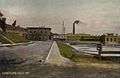 Cumberland Mills c. 1907
Geography
Westbrook is located at 43°41′7″N 70°21′26″W / 43.68528°N 70.35722°W (43.685348, −70.357116).[8]
According to the United States Census Bureau, the city has a total area of 17.33 square miles (44.88 km2), of which, 17.12 square miles (44.34 km2) is land and 0.21 square miles (0.54 km2) is water.[1]
Bodies of Water
Westbrook is drained primarily by two rivers. The Presumpscot River flows through the center of the city, with two prominent falls (the aforementioned Saccarappa Falls and Congin Falls). The smaller Stroudwater River flows through the southwestern part of the city. The city also contains part of Highland Lake.
Roads and Bordering
Westbrook is served by Interstate 95, U.S. Route 302 and State Routes 22 and 25. State Route 25 has a business route, Route 25 business. It is bordered by Portland to the east, South Portland and Scarborough to the south, Gorham and Windham to the west, and Falmouth to the north.
Little Roads
There are little roads flowing through the city. Little Roads include:
- Bridge Street
- East Bridge Street
- New Gorham Road
- Methodist Road
- Mast Road
Demographics
| Historical population | |||
|---|---|---|---|
| Census | Pop. | %± | |
| 1820 | 2,502 | — | |
| 1830 | 3,238 | 29.4% | |
| 1840 | 4,116 | 27.1% | |
| 1850 | 4,852 | 17.9% | |
| 1860 | 5,113 | 5.4% | |
| 1870 | 6,583 | 28.8% | |
| 1880 | 3,981 | −39.5% | |
| 1890 | 6,632 | 66.6% | |
| 1900 | 7,283 | 9.8% | |
| 1910 | 8,281 | 13.7% | |
| 1920 | 9,453 | 14.2% | |
| 1930 | 10,807 | 14.3% | |
| 1940 | 11,087 | 2.6% | |
| 1950 | 12,284 | 10.8% | |
| 1960 | 13,820 | 12.5% | |
| 1970 | 14,444 | 4.5% | |
| 1980 | 14,976 | 3.7% | |
| 1990 | 16,121 | 7.6% | |
| 2000 | 16,142 | 0.1% | |
| 2010 | 17,494 | 8.4% | |
| Est. 2015 | 17,978 | [9] | 2.8% |
| [10][11][12] | |||
2010 census
As of the census[2] of 2010, there were 17,494 people, 7,568 households, and 4,456 families residing in the city. The population density was 1,021.8 inhabitants per square mile (394.5/km2). There were 7,989 housing units at an average density of 466.6 per square mile (180.2/km2). The racial makeup of the city was 92.3% White, 2.3% African American, 0.2% Native American, 1.9% Asian, 0.1% Pacific Islander, 0.6% from other races, and 2.5% from two or more races. Hispanic or Latino of any race were 1.9% of the population.
There were 7,568 households of which 28.3% had children under the age of 18 living with them, 41.2% were married couples living together, 13.1% had a female householder with no husband present, 4.6% had a male householder with no wife present, and 41.1% were non-families. 30.4% of all households were made up of individuals and 12.2% had someone living alone who was 65 years of age or older. The average household size was 2.30 and the average family size was 2.87.
The median age in the city was 39.4 years. 20.9% of residents were under the age of 18; 8.2% were between the ages of 18 and 24; 29.1% were from 25 to 44; 26.5% were from 45 to 64; and 15.2% were 65 years of age or older. The gender makeup of the city was 47.7% male and 52.3% female.
2000 census
As of the census[13] of 2000, there were 16,142 people, 6,863 households, and 4,261 families residing in the city. The population density was 956.9 people per square mile (369.4/km²). There were 7,089 housing units at an average density of 420.3 per square mile (162.2/km²). The racial makeup of the city was 96.69% White, 0.88% African American, 0.27% Native American, 0.82% Asian, 0.03% Pacific Islander, 0.28% from other races, and 1.03% from two or more races. Hispanic or Latino of any race were 0.89% of the population.
There were 6,863 households out of which 29.4% had children under the age of 18 living with them, 46.3% were married couples living together, 12.6% had a female householder with no husband present, and 37.9% were non-families. 30.4% of all households were made up of individuals and 13.0% had someone living alone who was 65 years of age or older. The average household size was 2.33 and the average family size was 2.90.
In the city the age distribution of the population shows 23.4% under the age of 18, 7.3% from 18 to 24, 31.0% from 25 to 44, 22.7% from 45 to 64, and 15.5% who were 65 years of age or older. The median age was 38 years. For every 100 females there were 89.1 males. For every 100 females age 18 and over, there were 82.8 males.
The median income for a household in the city was $37,873, and the median income for a family was $47,120. Males had a median income of $32,412 versus $25,769 for females. The per capita income for the city was $19,501. About 6.7% of families and 8.3% of the population were below the poverty line, including 13.7% of those under age 18 and 5.7% of those age 65 or over.
Economy
Now primarily a suburb of the larger city of Portland, Westbrook itself has a growing business base and developing core downtown district. IDEXX Laboratories, Inc., a multi-national corporation, is headquartered in Westbrook.[14] In addition to the downtown area, many of the city's businesses are located within two industrial parks (the Col. Westbrook Industrial Park and Five Star Industrial Park), as well as in the area surrounding Maine Turnpike Exit 48.
The city is home to Sappi Ltd.'s Westbrook Paper Mill and R&D Center.[15] The mill, formerly the S. D. Warren Paper Mill, was once the city's largest employer and taxpayer, employing over 3,000 people and representing over 50% of the city's tax base. However, foreign competition and the age of the mill have drastically reduced its workforce and production. Today the mill has found a niche in the marketplace, becoming one of the nation's top manufacturers of release papers and employing about 300 people. The Calpine-Westbrook Energy Center has since surpassed the mill as the city's largest taxpayer. Westbrook was also the home of the first Sebago-Moc shoe factory.
Westbrook is home to WMTW, southern Maine's ABC affiliate. The station has its studios off County Road.
The faith-based Mercy Hospital of Portland operates Mercy Westbrook,[16] a small community hospital with a minor emergency room and inpatient treatment facilities. Spring Harbor Hospital, southern Maine's only private psychiatric treatment and recovery center, is also located within the city.
Education

- Westbrook School Department
- Westbrook High School – Blue Blazes
- Westbrook Middle School, grades 5 – 8 (formerly Fred C. Wescott Junior High School) – Falcons
- Congin Elementary School, grades K – 4 – Cougars
- Canal School Elementary School, grades K – 4 – Coyotes
- Pride's Corner Elementary School CLOSED June 2012
- Saccarappa Elementary School, grades K – 4 – Shining Stars
Churches
Catholic
- St. Anthony of Padua (St. Hyacinth)
- St. Mary's
- St. Edmund's
Evangelical Free
- First Evangelical Free Church
Lutheran
- Trinity Lutheran Church
Methodist-United
- Westbrook United Methodist
Nondenominational or Interdenominational
- New Life Fellowship
Not Indicated
- Covenant Family Fellowship
Pentecostal
- Vineyard Christian Fellowship
United Church of Christ
- Westbrook-Warren Congregational Church
Baptist
- First Baptist Church
- Westbrook Baptist Church
Government and elections
The Westbrook City Council consists of five district councilors and 2 at-large councilors. Colleen Hilton has been mayor of Westbrook since November 2009.[17]
Voter registration
| Voter Registration and Party Enrollment as of November 2012[18] | |||||
|---|---|---|---|---|---|
| Party | Total Voters | Percentage | |||
| Democratic | 4,516 | 37.93% | |||
| Unenrolled | 4,106 | 34.48% | |||
| Republican | 2,754 | 23.13% | |||
| Green Independent | 525 | 4.40% | |||
| Total | 11,905 | 100% | |||
Libraries
- Walker Memorial Library
- Warren Memorial Library (closed in 2009)
Neighborhoods
Similar to neighboring Portland and South Portland, Westbrook contains several distinct neighborhoods that are generally recognized by residents but have no legal or political significance. Unlike Portland, however, there is no official signage recognizing these neighborhoods. Some of the notable neighborhoods include:
- Birdland
- Cumberland Mills
- Deer Hill
- Frenchtown
- The Hamlet
- Pride's Corner
- Old Millbrook
- Westbrook Pointe
- Woodland
- Colonial Village
- Highland Lake
Recreation
In addition to the sports complexes located at Westbrook High School and other schools, the city offers several public recreational areas and facilities, including:
- Bicentennial Park & Skate Park
- Riverbank Park
- Westbrook River Walk – along Presumpscot River in downtown area
- Cornelia Warren Memorial Trail – along Presumpscot River between Ash St. and Cumberland St.
- Westbrook River Trail – along Presumpscot River north and east of the Sappi paper mill
- Rocky Hill – network of trails behind Wescott Community Centre
- Warren Little League Complex
- Lincoln Street skating rink – ice hockey in colder months, roller hockey in warmer months
- East Bridge Street skating rink – winter use only
- Stroudwater Street skating rink – winter use only
- East Bridge Street ballfields
- Warren League Grounds
- Warren Pool – outdoor public pool, summer use only
- Davan Pool – indoor pool, open year-round
Westbrook is home to the 2002 Maine State Little League Champions, the 2005 Senior Babe Ruth State Champions (who advanced to the regionals in New Hampshire), the 2005 12 Year Old Little League New England Regional Champions, the 2006 13 Year Old Babe Ruth New England Champions, and the 2008 15 Year Old Babe Ruth World Championship runners-up.
Sites of interest
Notable people

- Benjamin Paul Akers, sculptor
- John Cumberland, pitcher with the New York Yankees, San Francisco Giants, St. Louis Cardinals, and California Angels
- Kevin Eastman,[19] cartoonist, co-creator of the Teenage Mutant Ninja Turtles
- James Deering Fessenden, Civil War general, born in Westbrook
- Robert W. Duplessie, Assistant Majority Leader of the Maine House of Representatives
- Ginger Fraser, American football player and coach.
- Scott Garland (aka. Scotty 2 Hotty), wrestler with the WWE
- George Gore, center fielder with the Chicago White Stockings, New York Giants, and St. Louis Browns
- Nancy A. Henry, poet
- Edmund Needham Morrill, U.S. Congressman and the 13th governor of Kansas
- Ann Peoples, state legislator
- Alexander Speirs, state legislator
- Avadis Tevanian, venture capitalist, senior executive at Apple
- Ronald Usher, state legislator
- Rudy Vallée, musician, band leader, actor and entertainer
- Thomas Westbrook, namesake of Westbrook
- Bryan Vokey, musician, comedian
References
- 1 2 "US Gazetteer files 2010". United States Census Bureau. Retrieved 2012-11-23.
- 1 2 "American FactFinder". United States Census Bureau. Retrieved 2012-11-23.
- ↑ "Population Estimates". United States Census Bureau. Retrieved 2013-07-05.
- 1 2 Varney, George (1886). "Westbrook". A Gazetteer of the State of Maine. Boston, Massachusetts: B. B. Russell. p. 582. Retrieved August 22, 2010.
- ↑ Barry, William David; Anderson, Patricia McGraw (2010). Susan L. Ransom, ed. Deering: A Social and Architectural History. Margaret W. Soule. Portland, Maine: Greater Portland Landmarks. ISBN 978-0-939761-14-2.
- ↑ Westbrook, Maine Genealogy Project
- ↑ Coolidge, Austin J.; John B. Mansfield (1859). A History and Description of New England. Boston, Massachusetts. p. 353.
- ↑ "US Gazetteer files: 2010, 2000, and 1990". United States Census Bureau. 2011-02-12. Retrieved 2011-04-23.
- ↑ "Annual Estimates of the Resident Population for Incorporated Places: April 1, 2010 to July 1, 2015". Retrieved July 2, 2016.
- ↑ http://www.census.gov/population/www/censusdata/cencounts/files/me190090.txt
- ↑ http://factfinder2.census.gov/faces/tableservices/jsf/pages/productview.xhtml?pid=DEC_10_PL_QTPL&prodType=table
- ↑ http://mapserver.lib.virginia.edu/
- ↑ "American FactFinder". United States Census Bureau. Retrieved 2008-01-31.
- ↑ Bridgers, Leslie (September 7, 2011). "Idexx gets OK for $30 million building". Portland Press Herald. Retrieved September 26, 2011.
- ↑ "150+ Years of Paper Making Excellence". Warrenreleasepapers.sappi.com. Sappi Ltd. 2010. Retrieved November 8, 2011.
- ↑ "Mercy Westbrook". Mercyhospital.org. Mercy Hospital. Retrieved November 8, 2011.
- ↑ "Mayor's Office – Westbrook". Retrieved 23 March 2013.
- ↑ "REGISTERED & ENROLLED VOTERS – STATEWIDE" (PDF). November 6, 2012. Retrieved 13 February 2013.
- ↑ Mcdermott, Deborah (December 8, 2012). "'Ninja Turtles' artist shares 'mind-blowing' story". Seacoast Online. Retrieved February 24, 2013.
External links
- City of Westbrook, Maine
- Walker Memorial Library
- Westbrook Arts & Culture Committee
- Maine.gov – Westbrook, Maine
- Westbrook Chamber of Commerce
- Westbrook Trail Blazes Snowmobile Club
- Saccarappa Lodge
- Maine Genealogy: Westbrook, Cumberland County, Maine
Municipalities and communities of Cumberland County, Maine, United States | ||
|---|---|---|
| Cities | 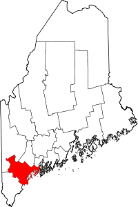 | |
| Towns | ||
| CDPs | ||
| Other villages | ||
Augusta (capital) | |
| Topics |
|
| Society |
|
| Regions | |
| Counties | |
| Cities | |
| Largest towns | |