Matinicus Isle, Maine
| Matinicus Island, Maine | |
|---|---|
| Plantation | |
|
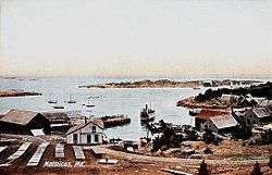
View of the harbor c. 1908 | |
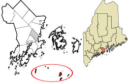 Location in Knox County and the state of Maine. | |
| Coordinates: 43°51′40″N 68°53′35″W / 43.86111°N 68.89306°WCoordinates: 43°51′40″N 68°53′35″W / 43.86111°N 68.89306°W | |
| Country | United States |
| State | Maine |
| County | Knox |
| Organized | 1840 |
| Area | |
| • Total | 106.5 sq mi (275.8 km2) |
| • Land | 1.6 sq mi (4.1 km2) |
| • Water | 104.9 sq mi (271.7 km2) |
| Elevation | 0 ft (0 m) |
| Population (2000) | |
| • Total | 51 |
| • Density | 31.8/sq mi (12.3/km2) |
| Time zone | Eastern (EST) (UTC-5) |
| • Summer (DST) | EDT (UTC-4) |
| Area code(s) | 207 |
| FIPS code | 23-44165 |
| GNIS feature ID | 0582584 |
Matinicus Isle is a plantation in Knox County, Maine, United States. The population was 51 at the 2000 census, although during the summer that number can triple or quadruple. Remote Matinicus Island is accessible by ferry from Rockland, located 20 miles (32 km) away, or by air taxi[1][2] from Knox County Regional Airport. Following a fatal crash on October 5, 2011, air taxi service was temporarily suspended, but has since resumed.[3][4]
History
Abenaki Indians called it Matinicus, meaning "far-out island." The French used it as an early fishing station.[5]
In early May 1717, several pirates from their snow (a type of two masted vessel), the Anne, raided several vessels that were off the shore of Matinicus at the time. The Anne had originally been captured off the Virginia Capes in April by the pirate Samuel Bellamy in the Whydah, which wrecked in a storm on the night of April 26, 1717, off of Cape Cod. The Anne made it through the storm with another captured vessel, the Fisher (which was soon abandoned and the pirates aboard her transferred to the Anne). The pirates arrived at Monhegan Island, Maine, on April 29 and waited for the Whydah, for the pirates had not seen or heard about the Whydah wrecking in the storm of the night of April 26. The pirates eventually realized the Whydah was lost, and proceeded to attack vessels in the area. Several of the pirates set out in a launch from the Anne and proceeded to Matinicus:
- "...where they took a sloop belonging to Colonel [Stephen] Minot, one shallop belonging to Capt. [John] Lane and three Schooners. They brought the Sloop and Shallop and (as we are informed) the sails and compasses of the 3 schooners to Menhagen [Monhegan], whereupon they manned the last mentioned Sloop with ten hands..."
The pirates soon departed the area on May 9, 1717, on the 25-ton sloop formerly belonging to Colonel Minot, with a pirate crew of 19.[6]
Matinicus was first settled in 1750 by a squatter, Ebenezer Hall, who had served as a lieutenant during the 1745 Battle of Louisburg. Accompanied by his family, he built a house and commenced farming, burning the land to produce better hay for his livestock. He also burned another island, infuriating the Penobscot Indians who hunted and fished in the area for their livelihood. At a trading post conference in 1752, Chief Colonel Louis said:
- "...one Hall and family, who live at Matinicus, interrupt us in our killing seals, and in our fowling; they have no right to be there; the land is our own."
Twice the tribe wrote letters to Royal authorities in Boston, complaining about Hall. In the second, delivered for forwarding on April 25, 1753, to Fort Richmond, they warned:
- "...if you don't remove him in two months, we shall be obliged to do it ourselves."
Governor Spencer Phips ordered Hall and his family brought into custody at Boston to answer for ignoring his command to leave Matinicus. But nothing happened. The Penobscots waited not two months but a little over four years before taking action. On June 1, 1757, they laid siege to Hall's house, and on June 10, 1757, killed and scalped him. Hall is buried in the vicinity of the so-called "store well," with a bronze plaque bolted to a ledge as commemoration. [7] So began the island's 250-year aura of insularity and frontier violence. Residents developed a reputation for wanting to be left alone; outsiders and tourists were not welcome. It was not infrequent for visiting sailboats to be shot at, and the Maine State Police were under orders not to be on the island after dark. Several boating magazines listed Matinicus as a "hostile harbor," and locals openly referred to it as a "pirate island." The state gave up enforcing vehicle laws on Matinicus in the 1950s, so license plates (and brakes) are optional on the rusted vehicles that ply its unpaved roads. More recently, however, outsiders have purchased property and built summer cottages on the island, whose economy is now comfortable with the seasonal influx of tourist dollars. Only interference in local lobster fishing invites trouble. [8] Matinicus shares with Vinalhaven what may be the richest lobstering grounds in the world.[9] With incomes reduced and the source of income at stake, territorial disputes can flare between fishermen. In July 2009, a 63-year-old resident and fisherman shot a 41-year-old fellow fisherman in a dispute over the locations of individual lobster-fishing rights.[10] Also, in 2006, shots were fired by a fisherman at another fisherman on his boat.
The island has a strong Christian presence and is a routine stop for the Maine Seacoast Mission's vessel Sunbeam. It has one church, built in 1906, and all island residents are somewhat affiliated with it. This, and an unwritten law to assist anyone in trouble, prompts island fishermen to be first responders at all sorts of marine emergencies in outer Penobscot Bay. On January 16, 1992, the tugboat Harkness sank, and it was a lobster boat from Matinicus that went out and found the three crewmen. The rescue is featured in the issue of Reader's Digest for March 1994.
.jpg)
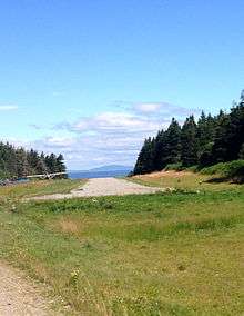
Geography
.jpg)
According to the United States Census Bureau, the plantation has a total area of 106.5 square miles (276 km2), of which 1.6 square miles (4.1 km2) is land and 104.9 square miles (271.7 km², or 98.49%) is water. Matinicus Isle Plantation comprises eight islands located on the fringes of Penobscot Bay in the Gulf of Maine, part of the Atlantic Ocean. Matinicus Island, the largest in the eight-island archipelago, is shaped like an oval approximately 2 miles (3.2 km) long by 1-mile (1.6 km) wide, containing about 800 acres (320 ha). Matinicus Rock Light is about five miles (8 km) east of Matinicus Island.
There are ten major fishing grounds around Matinicus Isle that the island's fishermen and Vinalhaven fishermen have used for centuries to catch cod, haddock, pollock, cusk, and lobster.
Weather
Weather around Matinicus is unpredictable and often harsh. Hurricane-force winds commonly blow for several days, and sometimes there is persistent fog from June to October. Though weather has been mild in recent years, historical patterns indicate that weather can be extreme. Winter storms are the most destructive, the last of significance being the Great Blizzard of 1978.
Demographics
| Historical population | |||
|---|---|---|---|
| Census | Pop. | %± | |
| 1870 | 277 | — | |
| 1880 | 243 | −12.3% | |
| 1890 | 196 | −19.3% | |
| 1900 | 184 | −6.1% | |
| 1910 | 179 | −2.7% | |
| 1920 | 140 | −21.8% | |
| 1930 | 156 | 11.4% | |
| 1940 | 112 | −28.2% | |
| 1950 | 188 | 67.9% | |
| 1960 | 100 | −46.8% | |
| 1970 | 90 | −10.0% | |
| 1980 | 66 | −26.7% | |
| 1990 | 67 | 1.5% | |
| 2000 | 51 | −23.9% | |
| 2010 | 74 | 45.1% | |
| Est. 2014 | 73 | [11] | −1.4% |
As of the census[13] of 2000, there were 51 people, 26 households, and 13 families residing in the plantation. The population density was 31.8 people per square mile (12.3/km²). There were 135 housing units at an average density of 84.3 per square mile (32.6/km²). The racial makeup of the plantation was 100.00% White.
There were 26 households, of which 15.4% had children under the age of 18, 53.8% were married couples living together, and 46.2% were non-families. Individual persons composed 34.6% of all households, and 15.4% had someone living alone who was 65 years of age or older. The average household size was 1.96; the average family size, 2.57.
The ages of the people of the plantation were spread out, with 15.7% under the age of 18, 5.9% aged from 18 to 24, 21.6% from 25 to 44, 39.2% from 45 to 64, and 17.6% aged 65 or older. The median age was 48 years. For every 100 females, there were 121.7 males. For every 100 females aged 18 or over, there were 126.3 males aged 18 or over.
The median income for a household in the plantation was $32,500, and the median income for a family was $41,250. Males had a median income of $40,000 versus $41,250 for females. The per capita income for the plantation was $15,537. There were no families and 11.8% of the population living below the poverty line, including none under eighteen and 50.0% of those over 64.
Sites of interest
See also
References
- ↑ According to a local, "(f)lying can be expensive ($70 or more per round trip) and landing on the short grass strip is not for the faint of heart." Bunker, "Matinicus," in Sustaining Island Communities, Rockland, Me.: Island Institute & Coastal Program, State Planning Office, State of Maine (1998)
- ↑ Auciello, Shlomit, Islanders Save Matinicus Plane Crash Victims, (Rockland, Maine) Village Soup, July 19, 2011
- ↑ Penobscot Island Air suspends flights after fatal crash Portland Press Herald, October 7, 2011.
- ↑ Parrish, Christine, Penobscot Island Air Back in Service After Fatal Plane Crash The Free Press, Oct. 13, 2011
- ↑ Eva Murray, "A Five-Minute History of Matinicus" 2010
- ↑ "Deposition of Ralph Merry and Samuel Roberts" Boston. May 11, May 16, 1717. in Jameson, John Franklin. "Privateering and Piracy in the Colonial Period: Illustrative Documents." New York: Macmillan Company, 1923, pp. 301-302; "John Newman to Governor Shute" Gloucester. May 12, 1717. Massachusetts Archives 51:290
- ↑ Ebenezer Hall of Matinicus Island - 1757
- ↑ Eva Murray, "A Little Mythbusting About Matinicus Island", DownEast.com 2010
- ↑ Fishing Grounds of the Gulf of Maine, by Walter Rich, US Bureau of Fisheries, 1929
- ↑ Clarke Canfield, "Lobster Wars Rock Remote Maine Island", 2009
- ↑ "Annual Estimates of the Resident Population for Incorporated Places: April 1, 2010 to July 1, 2014". Retrieved June 4, 2015.
- ↑ "Census of Population and Housing". Census.gov. Retrieved June 4, 2015.
- ↑ "American FactFinder". United States Census Bureau. Retrieved 2008-01-31.
External links
- Matinicus Island Community Website
- Matinicus Information
- Maine Seacoast Mission
- Matinicus Island Peapod
- Maine Genealogy: Matinicus Isle Plantation, Knox County, Maine
- Matinicus Island overview
Municipalities and communities of Knox County, Maine, United States | ||
|---|---|---|
| City | 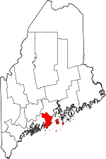 | |
| Towns | ||
| Plantation | ||
| Unorganized territory | ||
| CDPs | ||
| Other villages | ||