Richmond, Minnesota
| Richmond, Minnesota | |
|---|---|
| City | |
|
Richmond's Water Tower, City Library, City Hall and Fire Station | |
| Motto: "On The Horseshoe Chain Of Lakes"[1] | |
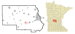 Location of Richmond within Stearns County, Minnesota | |
| Coordinates: 45°27′13″N 94°31′10″W / 45.45361°N 94.51944°W | |
| Country | United States |
| State | Minnesota |
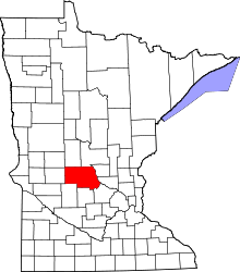
| County | Stearns |
| Area[2] | |
| • Total | 1.05 sq mi (2.72 km2) |
| • Land | 1.03 sq mi (2.67 km2) |
| • Water | 0.02 sq mi (0.05 km2) |
| Elevation | 1,122 ft (342 m) |
| Population (2010)[3] | |
| • Total | 1,422 |
| • Estimate (2012[4]) | 1,425 |
| • Density | 1,380.6/sq mi (533.1/km2) |
| Time zone | Central (CST) (UTC-6) |
| • Summer (DST) | CDT (UTC-5) |
| ZIP code | 56368 |
| Area code(s) | 320 |
| FIPS code | 27-54268[5] |
| GNIS feature ID | 0650067[6] |
| Website | www.ci.richmond.mn.us |

Richmond is a city in Stearns County, Minnesota, United States. The population was 1,422 at the 2010 census.[7] Richmond is part of the St. Cloud Metropolitan Statistical Area.[8]
History
Richmond was platted in 1856 by Reuben Richardson.[9]
Geography and transportation
According to the United States Census Bureau, the city has a total area of 1.05 square miles (2.72 km2); 1.03 square miles (2.67 km2) is land and 0.02 square miles (0.05 km2) is water.[2]
Minnesota State Highways 22 and 23 are two of the main routes in the city. Richmond is 12 miles west of Interstate 94 along Highway 23.
Demographics
| Historical population | |||
|---|---|---|---|
| Census | Pop. | %± | |
| 1900 | 600 | — | |
| 1910 | 563 | −6.2% | |
| 1920 | 651 | 15.6% | |
| 1930 | 603 | −7.4% | |
| 1940 | 634 | 5.1% | |
| 1950 | 700 | 10.4% | |
| 1960 | 751 | 7.3% | |
| 1970 | 866 | 15.3% | |
| 1980 | 867 | 0.1% | |
| 1990 | 965 | 11.3% | |
| 2000 | 1,213 | 25.7% | |
| 2010 | 1,422 | 17.2% | |
| Est. 2015 | 1,435 | [10] | 0.9% |
2010 census
As of the census[3] of 2010, there were 1,422 people, 1,903 households, and 1,411 families residing in the city. The population density was 1,380.6 inhabitants per square mile (533.1/km2). There were 627 housing units at an average density of 608.7 per square mile (235.0/km2). The racial makeup of the city was 98.0% White, 0.1% African American, 0.6% Asian, 0.6% from other races, and 0.7% from two or more races. Hispanic or Latino of any race were 1.8% of the population.
There were 1,903 households of which 28.3% had children under the age of 18 living with them, 56.3% were married couples living together, 6.5% had a female householder with no husband present, 4.5% had a male householder with no wife present, and 32.8% were non-families. 26.8% of all households were made up of individuals and 14% had someone living alone who was 65 years of age or older. The average household size was 2.43 and the average family size was 2.98.
The median age in the city was 39.4 years. 23.8% of residents were under the age of 18; 6.9% were between the ages of 18 and 24; 26.3% were from 25 to 44; 25.2% were from 45 to 64; and 17.8% were 65 years of age or older. The gender makeup of the city was 50.6% male and 49.4% female.
2000 census
As of the census[5] of 2000, there were 1,213 people, 483 households, and 943 families residing in the city. The population density was 2,421.5 people per square mile (551.0/km²). There were 1,098 housing units at an average density of 583.6 per square mile (226.2/km²). The racial makeup of the city was 99.98% White, 0.02% African American, 0.00% Asian, 0.00% from other races, and 0.0% from two or more races. Hispanic or Latino of any race were 0.33% of the population.
There were 483 households out of which 31.9% had children under the age of 18 living with them, 61.5% were married couples living together, 5.8% had a female householder with no husband present, and 28.8% were non-families. 23.6% of all households were made up of individuals and 13.5% had someone living alone who was 65 years of age or older. The average household size was 2.49 and the average family size was 2.95.
In the city the population was spread out with 24.8% under the age of 18, 7.3% from 18 to 24, 29.8% from 25 to 44, 18.7% from 45 to 64, and 19.3% who were 65 years of age or older. The median age was 38 years. For every 100 females there were 102.8 males. For every 100 females age 18 and over, there were 95.3 males.
The median income for a household in the city was $38,400, and the median income for a family was $44,464. Males had a median income of $29,315 versus $21,219 for females. The per capita income for the city was $15,995. About 4.4% of families and 6.6% of the population were below the poverty line, including 8.0% of those under age 18 and 11.9% of those age 65 or over.
Notable people
References
- ↑ "City of Richmond Minnesota". City of Richmond Minnesota. Retrieved October 9, 2012.
- 1 2 "US Gazetteer files 2010". United States Census Bureau. Archived from the original on January 24, 2012. Retrieved 2012-11-13.
- 1 2 "American FactFinder". United States Census Bureau. Retrieved 2012-11-13.
- ↑ "Population Estimates". United States Census Bureau. Archived from the original on June 17, 2013. Retrieved 2013-05-28.
- 1 2 "American FactFinder". United States Census Bureau. Archived from the original on September 11, 2013. Retrieved 2008-01-31.
- ↑ "US Board on Geographic Names". United States Geological Survey. 2007-10-25. Retrieved 2008-01-31.
- ↑ "2010 Census Redistricting Data (Public Law 94-171) Summary File". American FactFinder. U.S. Census Bureau, 2010 Census. Archived from the original on July 21, 2011. Retrieved 23 April 2011.
- ↑ "Profile for Richmond, Minnesota, MN". ePodunk. Retrieved October 9, 2012.
- ↑ Upham, Warren (1920). Minnesota Geographic Names: Their Origin and Historic Significance. Minnesota Historical Society. p. 526.
- ↑ "Annual Estimates of the Resident Population for Incorporated Places: April 1, 2010 to July 1, 2015". Retrieved July 2, 2016.
- ↑ "Census of Population and Housing". Census.gov. Archived from the original on May 11, 2015. Retrieved June 4, 2015.
External links
| Wikimedia Commons has media related to Richmond, Minnesota. |
- City Website
- Richmond Civic and Commerce Association – Business and Community Information site
- City-Data.com
- ePodunk: Profile for Richmond, Minnesota
Municipalities and communities of Stearns County, Minnesota, United States | ||
|---|---|---|
| Cities |
|  |
| Townships |
| |
| CDP | ||
| Unincorporated communities | ||
| Footnotes | ‡This populated place also has portions in an adjacent county or counties | |
| Core City |  | ||||||
|---|---|---|---|---|---|---|---|
| Surrounding communities |
| ||||||
| Counties | |||||||
‡ indicates that it is partially in the metropolitan area. § indicates a CDP | |||||||
Coordinates: 45°27′15″N 94°31′06″W / 45.45417°N 94.51833°W