Sauk Rapids, Minnesota
| Sauk Rapids, Minnesota | |
|---|---|
| City | |
 | |
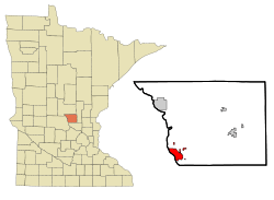 Location of Sauk Rapids within Benton County and state of Minnesota | |
| Coordinates: 45°35′34″N 94°9′50″W / 45.59278°N 94.16389°WCoordinates: 45°35′34″N 94°9′50″W / 45.59278°N 94.16389°W | |
| Country | United States |
| State | Minnesota |
| County | Benton |
| Area[1] | |
| • Total | 6.35 sq mi (16.45 km2) |
| • Land | 6.10 sq mi (15.80 km2) |
| • Water | 0.25 sq mi (0.65 km2) |
| Elevation | 1,033 ft (315 m) |
| Population (2010)[2] | |
| • Total | 12,773 |
| • Estimate (2015)[3] | 13,424 |
| • Density | 2,093.9/sq mi (808.5/km2) |
| Time zone | Central (CST) (UTC-6) |
| • Summer (DST) | CDT (UTC-5) |
| ZIP code | 56379 |
| Area code(s) | 320 |
| FIPS code | 27-58684[4] |
| GNIS feature ID | 0651235[5] |
| Website | www.ci.sauk-rapids.mn.us |
Sauk Rapids is a city in Benton County, Minnesota, United States. The population was 12,773 at the 2010 census and is 13,424 according to 2015 census estimates.[6] It is located on a set of rapids on the Mississippi River near its confluence with the Sauk River.
Sauk Rapids is part of the St. Cloud Metropolitan Statistical Area.
History
.jpg)
Sauk Rapids was originally little more than a forest of oak, maple and basswood trees along the Mississippi River until the first home was constructed there in 1851, a large mansion named Lynden Terrace erected by W.H. Wood. Soon other settlers followed and the town was named Sauk Rapids after the rapids just below the Sauk River's mouth on the Mississippi. Soon a general store was built, then a hotel, and a large jail. The first settlers organized a Congregational church that was soon followed by a Methodist, an Episcopalian and a Lutheran church. The first paper outside of St. Paul was the "Sauk Rapids Frontiersman," founded in 1854.[7]
A flour mill was erected in 1875, but was destroyed in 1886. In 1876, the first bridge was built, was destroyed later in 1876, but rebuilt in 1879. The first school was built in 1886.
In 1874, Sauk Rapids was the end of the line for the local railroad. All the settlers from as far away as the upper Red River Valley brought their produce there to ship it. A six-horse stage coach made bi-weekly trips between St. Cloud and Crow Wing.
In 1856, the county seat moved to Watab, then returned to Sauk Rapids in 1859. A new courthouse was built, but in 1897 the seat moved to Foley where it currently resides. In 1917 the courthouse burned down.
Sauk Rapids was one of the most important cities in Minnesota until 1886, when, on April 14 at approximately 4:00 p.m., a tornado struck the town. The twister swept through the heart of the city, destroying all of the stores. In Sauk Rapids alone, 44 people were killed and several hundred were wounded. The event was a great setback for the city, and though it has rebuilt since then it never regained its former prominence in statewide affairs.
In recent years, the downtown area of Sauk Rapids has gone through substantial changes due to the construction of the New Sauk Rapids Bridge.[8] This was primarily because the new bridge links to 2nd Street rather than 1st Street, as the original Sauk Rapids Bridge did. Also the intersection of Benton Drive and 2nd street was adjusted so the new bridge would extend over the railroad tracks and land on Benton Drive. Several buildings had to be demolished during the construction process, which meant that some parts of downtown were rebuilt. In addition, some sidewalks were repaved with cobblestone and the medians were filled with granite blocks.
Law and government
Sauk Rapids' city council consists of a mayor and four City Council members elected at-large to represent the community and legislate citywide policy. Sauk Rapids' mayor is Brad Gunderson and its four council members are Steve Heinen, Kurt Hunstiger, Nick Sauer, and Paul Weber. They possess the authority to pass and enforce ordinances, establish public and administrative policies, create advisory boards and commissions, and limit the number of garbage trucks traversing the city streets. The City Council also appoints a City Administrator who oversees the day-to-day operations of the city and implements the policies of the Council.
City recreational facilities include 22 parks, nature preserves, paved walking paths, playgrounds, tennis courts, baseball and soccer fields, a golf course, public splash pad, and a wading pool.[9][10]
Schools
Sauk Rapids has 5 schools present with 4 public and 1 private. The schools include Mississippi Heights Elementary, Pleasantview Elementary, Sauk Rapids-Rice Middle School, Sauk Rapids-Rice High School, and Petra Lutheran School.
Geography
According to the United States Census Bureau, the city has a total area of 6.35 square miles (16.45 km2), of which 6.10 square miles (15.80 km2) is land and 0.25 square miles (0.65 km2) is water.[1]
U.S. Highway 10 and Minnesota State Highway 15 are two of the main routes in Sauk Rapids. Other nearby routes include Interstate 94, Minnesota State Highway 23, and County Road 75. Sauk Rapids is immediately northeast of the city of St. Cloud, on the east bank of the Mississippi River.
Demographics
| Historical population | |||
|---|---|---|---|
| Census | Pop. | %± | |
| 1860 | 167 | — | |
| 1870 | 412 | 146.7% | |
| 1880 | 598 | 45.1% | |
| 1890 | 1,185 | 98.2% | |
| 1900 | 1,391 | 17.4% | |
| 1910 | 1,745 | 25.4% | |
| 1920 | 2,349 | 34.6% | |
| 1930 | 2,656 | 13.1% | |
| 1940 | 2,981 | 12.2% | |
| 1950 | 3,410 | 14.4% | |
| 1960 | 4,038 | 18.4% | |
| 1970 | 5,051 | 25.1% | |
| 1980 | 5,793 | 14.7% | |
| 1990 | 7,825 | 35.1% | |
| 2000 | 10,213 | 30.5% | |
| 2010 | 12,773 | 25.1% | |
| Est. 2015 | 13,424 | [11] | 5.1% |
| U.S. Decennial Census[12] 2015 Estimate[3] | |||
2010 census
As of the census[2] of 2010, there were 12,773 people, 4,960 households, and 3,222 families residing in the city. The population density was 2,093.9 inhabitants per square mile (808.5/km2). There were 5,219 housing units at an average density of 855.6 per square mile (330.3/km2). The racial makeup of the city was 94.9% White, 1.2% African American, 0.5% Native American, 1.2% Asian, 0.4% from other races, and 1.8% from two or more races. Hispanic or Latino of any race were 1.8% of the population.
There were 4,960 households of which 36.6% had children under the age of 18 living with them, 48.9% were married couples living together, 11.0% had a female householder with no husband present, 5.0% had a male householder with no wife present, and 35.0% were non-families. 26.8% of all households were made up of individuals and 9.2% had someone living alone who was 65 years of age or older. The average household size was 2.49 and the average family size was 3.03.
The median age in the city was 32.8 years. 25.9% of residents were under the age of 18; 9.8% were between the ages of 18 and 24; 31.2% were from 25 to 44; 22.4% were from 45 to 64; and 10.8% were 65 years of age or older. The gender makeup of the city was 48.8% male and 51.2% female.
2000 census
As of the census[4] of 2000, there were 10,213 people, 3,921 households, and 2,599 families residing in the city. The population density was 2,234.1 people per square mile (862.9/km²). There were 4,017 housing units at an average density of 878.7 per square mile (339.4/km²). The racial makeup of the city was 97.11% White, 0.57% African American, 0.31% Native American, 0.78% Asian, 0.04% Pacific Islander, 0.23% from other races, and 0.96% from two or more races. Hispanic or Latino of any race were 1.08% of the population.
There were 3,921 households out of which 37.9% had children under the age of 18 living with them, 52.1% were married couples living together, 10.9% had a female householder with no husband present, and 33.7% were non-families. 26.2% of all households were made up of individuals and 10.3% had someone living alone who was 65 years of age or older. The average household size was 2.53 and the average family size was 3.09.
In the city the population was spread out with 28.1% under the age of 18, 9.6% from 18 to 24, 33.4% from 25 to 44, 17.8% from 45 to 64, and 11.2% who were 65 years of age or older. The median age was 32 years. For every 100 females there were 91.5 males. For every 100 females age 18 and over, there were 86.1 males.
The median income for a household in the city was $45,857, and the median income for a family was $53,938. Males had a median income of $36,074 versus $24,657 for females. The per capita income for the city was $19,510. About 2.8% of families and 4.9% of the population were below the poverty line, including 4.5% of those under age 18 and 10.2% of those age 65 or over.
Notable people
- James Beatty, Minnesota pioneer and territorial legislator[13]
- Rip Repulski, MLB All-Star baseball player
- Walter F. Rogosheske, Minnesota jurist and legislator[14]
- Jeremiah Russell, pioneer and territorial legislator[15]
References
- 1 2 "US Gazetteer files 2010". United States Census Bureau. Retrieved 2012-11-13.
- 1 2 "American FactFinder". United States Census Bureau. Retrieved 2012-11-13.
- 1 2 "Population Estimates". United States Census Bureau. Retrieved June 17, 2016.
- 1 2 "American FactFinder". United States Census Bureau. Retrieved 2008-01-31.
- ↑ "US Board on Geographic Names". United States Geological Survey. 2007-10-25. Retrieved 2008-01-31.
- ↑ "2010 Census Redistricting Data (Public Law 94-171) Summary File". American FactFinder. U.S. Census Bureau, 2010 Census. Retrieved 23 April 2011.
- ↑ http://98country.com/tags/sauk-rapids-frontiersman/
- ↑ http://www.johnweeks.com/river_mississippi/pages03/newsaukrapids.html
- ↑ "Parks". City of Sauk Rapids website. Retrieved 2009-09-05.
- ↑ "Park Amenities". City of Sauk Rapids. Retrieved 2009-09-05.
- ↑ "Annual Estimates of the Resident Population for Incorporated Places: April 1, 2010 to July 1, 2015". Retrieved July 2, 2016.
- ↑ United States Census Bureau. "Census of Population and Housing". Retrieved June 17, 2016.
- ↑ Minnesota legislators Past and Present-James Beatty
- ↑ Minnesota State Law Library-Walter F. Rogosheske
- ↑ Benton County, Minnesota Biographies
External links
Municipalities and communities of Benton County, Minnesota, United States | ||
|---|---|---|
| Cities | 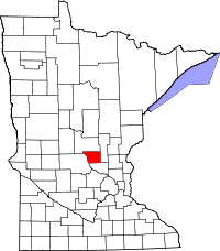 | |
| Townships | ||
| CDP | ||
| Unincorporated communities | ||
| Ghost town | ||
| Footnotes | ‡This populated place also has portions in an adjacent county or counties | |
| Core City | 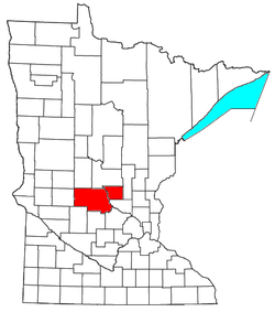 | ||||||
|---|---|---|---|---|---|---|---|
| Surrounding communities |
| ||||||
| Counties | |||||||
‡ indicates that it is partially in the metropolitan area. § indicates a CDP | |||||||