Cold Spring, Minnesota
| Cold Spring, Minnesota | |
|---|---|
| City | |
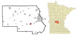 Location of Cold Spring within Stearns County, Minnesota | |
| Coordinates: 45°27′N 94°26′W / 45.450°N 94.433°WCoordinates: 45°27′N 94°26′W / 45.450°N 94.433°W | |
| Country | United States |
| State | Minnesota |
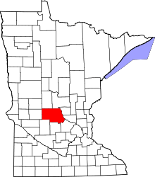
| County | Stearns |
| Area[1] | |
| • Total | 2.70 sq mi (6.99 km2) |
| • Land | 2.67 sq mi (6.92 km2) |
| • Water | 0.03 sq mi (0.08 km2) |
| Elevation | 1,099 ft (335 m) |
| Population (2010)[2] | |
| • Total | 4,025 |
| • Estimate (2012[3]) | 4,027 |
| • Density | 1,507.5/sq mi (582.0/km2) |
| Time zone | Central (CST) (UTC-6) |
| • Summer (DST) | CDT (UTC-5) |
| ZIP code | 56320 |
| Area code(s) | 320 |
| FIPS code | 27-12484[4] |
| GNIS feature ID | 0641388[5] |
| Website | www.coldspring.govoffice.com |
Cold Spring is a city in Stearns County, Minnesota, United States. The population was 4,025 at the 2010 census.[6] It is part of the St. Cloud Metropolitan Statistical Area.
Geography

According to the United States Census Bureau, the city has a total area of 2.70 square miles (6.99 km2); 2.67 square miles (6.92 km2) is land and 0.03 square miles (0.08 km2) is water.[1]
Minnesota Highway 23 serves as a main route in the city.
The city of Cold Spring is located within Wakefield Township geographically but is a separate entity.
History
Cold Spring was platted in 1856, and named for the fact there were many springs near the original town site.[7] A post office has been in operation at Cold Spring since 1857.[8]
The city was thrust in the national spotlight on September 24, 2003, when then 15-year-old Jason McLaughlin shot and killed two classmates in the Rocori High School shooting.
Demographics
| Historical population | |||
|---|---|---|---|
| Census | Pop. | %± | |
| 1900 | 486 | — | |
| 1910 | 594 | 22.2% | |
| 1920 | 705 | 18.7% | |
| 1930 | 1,147 | 62.7% | |
| 1940 | 1,427 | 24.4% | |
| 1950 | 1,488 | 4.3% | |
| 1960 | 1,760 | 18.3% | |
| 1970 | 2,006 | 14.0% | |
| 1980 | 2,294 | 14.4% | |
| 1990 | 2,459 | 7.2% | |
| 2000 | 2,975 | 21.0% | |
| 2010 | 4,025 | 35.3% | |
| Est. 2015 | 4,094 | [9] | 1.7% |
| U.S. Decennial Census | |||
2010 census
As of the census[2] of 2010, there were 4,025 people, 1,549 households, and 1,049 families residing in the city. The population density was 1,507.5 inhabitants per square mile (582.0/km2). There were 1,641 housing units at an average density of 614.6 per square mile (237.3/km2). The racial makeup of the city was 94.2% White, 0.2% African American, 0.2% Native American, 0.2% Asian, 0.1% Pacific Islander, 3.9% from other races, and 1.0% from two or more races. Hispanic or Latino of any race were 7.1% of the population.
There were 1,549 households of which 36.6% had children under the age of 18 living with them, 53.6% were married couples living together, 10.1% had a female householder with no husband present, 4.0% had a male householder with no wife present, and 32.3% were non-families. 27.8% of all households were made up of individuals and 16.4% had someone living alone who was 65 years of age or older. The average household size was 2.54 and the average family size was 3.11.
The median age in the city was 36.7 years. 27.7% of residents were under the age of 18; 6.5% were between the ages of 18 and 24; 26.4% were from 25 to 44; 20.4% were from 45 to 64; and 19% were 65 years of age or older. The gender makeup of the city was 48.3% male and 51.7% female.
2000 census
As of the census[4] of 2000, there were 2,975 people, 1,116 households, and 785 families residing in the city. The population density was 1,431.1 people per square mile (552.2/km²). There were 1,145 housing units at an average density of 550.8 per square mile (212.5/km²). The racial makeup of the city was 98.39% White, 0.20% African American, 0.07% Native American, 0.20% Asian, 0.71% from other races, and 0.44% from two or more races. Hispanic or Latino of any race were 1.34% of the population.
There were 1,116 households out of which 36.9% had children under the age of 18 living with them, 58.1% were married couples living together, 8.6% had a female householder with no husband present, and 29.6% were non-families. 26.3% of all households were made up of individuals and 16.6% had someone living alone who was 65 years of age or older. The average household size was 2.56 and the average family size was 3.11.
In the city the population was spread out with 27.8% under the age of 18, 7.2% from 18 to 24, 26.6% from 25 to 44, 17.4% from 45 to 64, and 21.0% who were 65 years of age or older. The median age was 37 years. For every 100 females there were 89.7 males. For every 100 females age 18 and over, there were 84.2 males.
The median income for a household in the city was $37,500, and the median income for a family was $50,268. Males had a median income of $32,225 versus $23,500 for females. The per capita income for the city was $18,308. About 1.9% of families and 3.3% of the population were below the poverty line, including 3.8% of those under age 18 and 6.9% of those age 65 or over.
Notable people
- Eric Decker, former wide receiver for the Minnesota Golden Gophers, and currently playing for the New York Jets, graduated from Rocori High School in Cold Spring.
References
- 1 2 "US Gazetteer files 2010". United States Census Bureau. Archived from the original on 2012-06-26. Retrieved 2012-11-13.
- 1 2 "American FactFinder". United States Census Bureau. Retrieved 2012-11-13.
- ↑ "Population Estimates". United States Census Bureau. Archived from the original on 2013-06-17. Retrieved 2013-05-28.
- 1 2 "American FactFinder". United States Census Bureau. Archived from the original on 2013-09-11. Retrieved 2008-01-31.
- ↑ "US Board on Geographic Names". United States Geological Survey. 2007-10-25. Retrieved 2008-01-31.
- ↑ "2010 Census Redistricting Data (Public Law 94-171) Summary File". American FactFinder. U.S. Census Bureau, 2010 Census. Archived from the original on 21 July 2011. Retrieved 23 April 2011.
- ↑ Upham, Warren (1920). Minnesota Geographic Names: Their Origin and Historic Significance. Minnesota Historical Society. p. 523.
- ↑ "Stearns County". Jim Forte Postal History. Archived from the original on 18 January 2016. Retrieved 8 August 2015.
- ↑ "Annual Estimates of the Resident Population for Incorporated Places: April 1, 2010 to July 1, 2015". Retrieved July 2, 2016.
External links
Municipalities and communities of Stearns County, Minnesota, United States | ||
|---|---|---|
| Cities |
|  |
| Townships |
| |
| CDP | ||
| Unincorporated communities | ||
| Footnotes | ‡This populated place also has portions in an adjacent county or counties | |
| Core City | 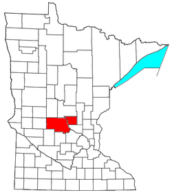 | ||||||
|---|---|---|---|---|---|---|---|
| Surrounding communities |
| ||||||
| Counties | |||||||
‡ indicates that it is partially in the metropolitan area. § indicates a CDP | |||||||