Randstad
| Randstad Randstad Regio | |
|---|---|
| Megalopolis | |
|
Amsterdam business district at night | |
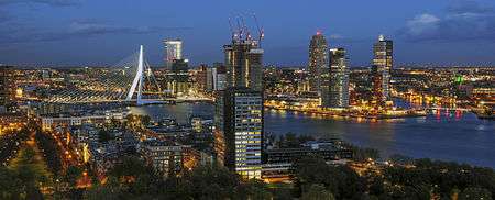 Rotterdam at dusk | |
 The Hague at dusk | |
| Coordinates: 52°24′N 4°54′E / 52.400°N 4.900°ECoordinates: 52°24′N 4°54′E / 52.400°N 4.900°E | |
| Country | Netherlands |
| Provinces |
North Holland |
| Largest cities |
Amsterdam Rotterdam The Hague Utrecht |
| Other municipalities |
Almere Haarlem Amersfoort Zaanstad Haarlemmermeer Zoetermeer Leiden Dordrecht Alphen aan den Rijn Westland Delft Alkmaar Purmerend Schiedam Hoorn Vlaardingen Gouda |
| Area[a] | |
| • Land | 8,287 km2 (3,200 sq mi) |
| • Urban[1] | 4,300 km2 (1,700 sq mi) |
| Highest elevation | 69 m (226 ft) |
| Lowest elevation | −6.76 m (−22.18 ft) |
| Population (2008)[2][b] | |
| • Megalopolis | 7,100,000 |
| • Urban | 6,600,000 |
| • Urban density | 1,500/km2 (4,000/sq mi) |
| Demonym(s) | Randstedeling (inhabitant), Randstedelijk (adjective) |
| Website |
regio-randstad |


The Randstad (Dutch pronunciation: [ˈrɑntstɑt]) is a megalopolis in the central-western Netherlands consisting primarily of the four largest Dutch cities (Amsterdam, Rotterdam, The Hague and Utrecht) and their surrounding areas. Among other things, it contains the Port of Rotterdam (the largest seaport in Europe, and until 2004 also the world's busiest seaport), and Amsterdam Airport Schiphol (one of the largest European airports). With a population of 7,100,000 it is one of the largest metropolitan regions in Europe,[b] comparable in size to Milan or the San Francisco Bay Area, and covers an area of approximately 8,287 km².[a] It's also one of the most important and densely populated economic areas in northwestern Europe.
The Randstad's main cities are Almere, Amersfoort, Amsterdam, Delft, Dordrecht, Gouda, Haarlem, Leiden, Rotterdam, The Hague, Utrecht, and Zoetermeer. Other centres include Alphen aan den Rijn, Amstelveen, Barendrecht, Capelle aan den IJssel, Hilversum, Hoofddorp, Hoek van Holland, Houten, Katwijk, Leidschendam, Maarssen, Maassluis, Nieuwegein, Oostzaan, Purmerend, Rijswijk, Schiedam, Spijkenisse, Vlaardingen, Voorburg, Zeist and Zaanstad.
Although the name Randstad is often translated into English as "edge city" or "border city", a more accurate translation would be "rim city". The Dutch name was coined in 1938 by KLM founder Albert Plesman who, while flying over the region, used it to describe a strip of cities at the rim of a large green agricultural area (the Green Heart).[3] While technically more of a crescent (the southeastern edge of the rim is significantly less populated), the ring shape formed by connecting the four major cities of the region led to the use of the name "Ring City".[3][4]
Culture
The Randstad has a history of competition. For instance, Rotterdam and Amsterdam, the two main cities, compete in many ways, from football to art.
Between the Randstad and the rest of the country a culture difference is also present.[5]
Geography
Recently, Dutch planners have started to refer to the Randstad as Deltametropool.[6] Deltametropolis actually consists of two large metropolitan areas:
1. The Noordvleugel (North Wing, with a population of around 3.6 million people), consisting of the Haarlem and IJmuiden conurbations in the west, Amsterdam at the centre and Almere, the Gooi area and Utrecht in the east. The conurbation of Utrecht (pop. around 1 million) can be considered to be part of this wing, but can also be excluded. The cultural centre of the Noordvleugel, however, is notably centered on Amsterdam, which could – as such – be considered a classical centralistic metropolis. Amsterdam recently started to present itself as the Amsterdam Metropolitan Area (Metropoolregio Amsterdam). The expectation is that the use of the Noordvleugel and the Randstad will become less as a result.[7] This part of the Randstad is expected to grow more in population than the Zuidvleugel and the Groene Hart/Green Heart areas, with the growth of population also being in effect for a longer period of time, compared to the other two areas.[8]
2. The Zuidvleugel (South Wing, with a population of around 3.5 million people), stretching some 60 kilometers from Dordrecht in the South East to Leiden in the North. The main conurbations are the Rotterdam and The Hague areas. The virtual centre of the Zuidvleugel lies in between these two major cities, near Delft. The first steps toward this development were taken with the construction of a new fast light-rail connection between Rotterdam and The Hague: RandstadRail. A long-delayed extension of the western A4-motorway from the south of Delft to Rotterdam has also been constructed, creating a second connection between Rotterdam, via The Hague, to Amsterdam.
A possible new area would be the Zuidoostflank; parallel to the A2 motorway (from Amsterdam to Eindhoven) and parallel to the A12 motorway (Utrecht to WERV (Wageningen, Ede, Rhenen and Veenendaal)), as this region has much potential to strengthen the knowledge economy of the Randstad.[9]
Over the last few decades, a major topic in the Randstad is the conflict between the cities and the towns in between. These towns and the surrounding countryside, known as the Groene Hart (Green Heart), are usually much greener than the cities, they house many commuters that work in the cities and the former strongly depend on the latter for facilities such as hospitals and large scale entertainment. Cities need more space to expand, yet the towns fear losing their identity and autonomy.
Boundary issues
The Randstad's borders have never been officially specified. Some consider only the four biggest cities of the Netherlands (Amsterdam, Rotterdam, The Hague and Utrecht) part of it, others would say that areas such as Alkmaar (which represents itself as being part of it),[10][11][12] Hoorn and Lelystad are also part of this conurbation. The publication "Randstad 2040", released by the Dutch government, reveals that the Noordvleugel (North Wing, Amsterdam and Utrecht region) is already growing parallel to the A1, A2, and A4 motorways, as well as into the northern part of North Holland (Alkmaar region) and Flevoland (Lelystad region).[13] There is also a trend shown that the Noordvleugel is expanding parallel to the A2 (Amsterdam towards Eindhoven) and A12 (Utrecht towards the WERV (Wageningen-Ede-Rhenen-Veenendaal)) motorways. This region is called the 'Zuidoostflank' (Southeastside).[9]
Transport
The Randstad possesses a large infrastructure system, with many railways, motorways, trams and subways in various cities. It is possible to cycle on reasonably safe and pleasant routes almost everywhere and cycling is a major mode of transport. The Port of Rotterdam, and Schiphol Airport, are both major international gateways. There are various smaller ports and airports in the Randstad, like the ports of IJmuiden, Amsterdam and Dordrecht, as well as Rotterdam-The Hague Airport.
Motorways
The Randstad has various motorways, most of them starting around Amsterdam and Rotterdam. Many international corridors start in the Randstad, including the A1, A2, A4, A5, A6, A7, A10, A12, A15, A16 and A20 motorways, as well as various commuter routes.
The Randstad network of motorways carry some of the highest traffic volumes in Europe. Until about 10 years ago most motorways used to be no wider than 2x2 or 2x3 lanes, but in recent years capacity of most major highways has been expanded to six or eight and on some parts even ten lanes. A 14-lane highway is projected near Utrecht. Some hard shoulders are in use as peak hour lanes – traffic is allowed to use the hard shoulder as a third or fourth lane during periods of congestion, when traffic management signs indicate. Since these expansions traffic jams (which used to be quite intense) have been reduced by up to 25%. Traffic on the highway still is quite heavy, though.
Because of the many obstructions in minor roads, such as one-way or circular routes (often created to make living neighbourhoods safer), a lot of local traffic also uses the motorways. There are a few missing links in the motorway network of the Randstad, especially on the A4 motorway, where construction has been a topic of debate since the 1960s. This results in quite heavy traffic on the alternative A13 highway between Rotterdam and the Hague.
Another growing issue is the number of trucks on the radiating motorways from the Randstad; truck volumes can be as high as 20,000 trucks per day, occupying the entire right lane on some motorways.
Railways
The Randstad is the keystone of the Dutch railway network; most intercity connections terminate in one of the key cities in the Randstad. The railway network in the area is dense and heavily used. Delays used to be common. Together with the Swiss Federal Railways (#1), and the Belgian railways (#3), the Dutch Railways are in the top 3 of Europe in punctuality.[14][15] Larger cities in the Randstad have many railway stations, as well as light rail, subway and/or tram networks.
Cycling
Much effort is being expended in increasing the cycling rate of the Randstad. The campaign Fietsfilevrij exists to encourage cycling as an alternative to waiting in traffic jams on the motorway. Bicycle superhighways have been built on which cyclists have priority for long distance, high speed cycle commuting. For instance, one of these stretches the 50 km distance between Amsterdam and Utrecht.
See also
- List of metropolitan areas in the European Union by GDP
- BrabantStad
- Blue Banana
- Global city
- Urban agglomeration
Notes
- ^ Randstad is not an official statistical area. The 'land area' figure is the sum of the areas of the 4 member provinces. The Randstad is normally not considered to cover the whole of any of these provinces.
- ^ Estimates range from a conservative 6.6 million to 7.6 million (full population of the 4 member provinces). The figure of 7.1 million is used in various official publications.
References
- ↑ "Approximation of area on Google Maps". 2010-10-16. Retrieved 2010-10-16.
- ↑ "Randstadmonitor 2010" (PDF). 2010-01-01. Retrieved 2011-07-21.
- 1 2 The Randstad conurbation: a floating metropolis in the Dutch Delta (PDF), Pim Kooij, Paul van de Laar; Rijksuniversiteit Groningen Journal Hosting
- ↑ Randstad (Region, Netherlands), Encyclopædia Britannica
- ↑ "Opzij, Randstad, maak plaats voor de provincie". NRC Handelsblad. 17 November 2006.
Generaliserend: cultureel is er een kloof tussen de Randstad en de rest van Nederland, ‘de provincie’, aan het ontstaan. De mensen die in de twee delen van ons land wonen zijn verschillend; hun beleving en ideeën zijn verschillend.
- ↑ "DELTAMETROPOOL". Deltametropool.nl. 2000-09-27. Retrieved 2010-05-22.
- ↑ Cohen, Job (2008-01-22). "Metropool Regio Amsterdam". City of Amsterdam. Retrieved 2008-07-25.
- ↑ http://www.rijksoverheid.nl/onderwerpen/randstad/documenten-en-publicaties/brochures/2007/06/01/randstad-2040-startnotitie-naar-een-duurzame-en-concurrerende-europese-topregio.html | Randstad 2040, page 28 (in Dutch)
- 1 2 http://www.rijksoverheid.nl/onderwerpen/randstad/documenten-en-publicaties/brochures/2007/06/01/randstad-2040-startnotitie-naar-een-duurzame-en-concurrerende-europese-topregio.html | Randstad 2040, page 25 (in Dutch)
- ↑ Deutsch-Alkmaar – Gemeente Alkmaar. Alkmaar.nl (2012-11-14). Retrieved on 2013-07-16.
- ↑ http://www.kennemerwonen.nl/uploads/U%20zoekt%20een%20woning/Wijkinformatie/Alkmaar%20Oudorp.pdf
- ↑ Alkmaar – Who or What is Alkmaar? Find out more. Encycl.opentopia.com. Retrieved on 2013-07-16.
- ↑ http://www.rijksoverheid.nl/onderwerpen/randstad/documenten-en-publicaties/brochures/2007/06/01/randstad-2040-startnotitie-naar-een-duurzame-en-concurrerende-europese-topregio.html | Randstad 2040, page 9 (in Dutch)
- ↑ http://www.treinreiziger.nl/kennisnet/punctualiteit/punctualiteit_ns_internationaal_vergeleken | Treinreiziger (in Dutch)
- ↑ http://www.treinreiziger.nl/kennisnet/andere_wisselverwarming_kan_spoorchaos_voorkomen-142138 | Treinreiziger (in Dutch)