Gouda, South Holland
| Gouda | |||
|---|---|---|---|
| City and Municipality | |||
|
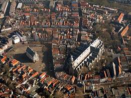
Market square with gothic city hall | |||
| |||
| Motto: Per aspera ad astra | |||
.svg.png) Location in South Holland | |||
| Coordinates: 52°1′N 4°43′E / 52.017°N 4.717°ECoordinates: 52°1′N 4°43′E / 52.017°N 4.717°E | |||
| Country | Netherlands | ||
| Province | South Holland | ||
| Government[1] | |||
| • Body | Municipal council | ||
| • Mayor | Milo Schoenmaker (VVD) | ||
| Area[2] | |||
| • Total | 18.11 km2 (6.99 sq mi) | ||
| • Land | 16.86 km2 (6.51 sq mi) | ||
| • Water | 1.25 km2 (0.48 sq mi) | ||
| Elevation[3] | 0 m (0 ft) | ||
| Population (May 2014)[4] | |||
| • Total | 70,939 | ||
| • Density | 4,208/km2 (10,900/sq mi) | ||
| Demonym(s) | Gouwenaar | ||
| Time zone | CET (UTC+1) | ||
| • Summer (DST) | CEST (UTC+2) | ||
| Postcode | 2800–2809 | ||
| Area code | 0182 | ||
| Website |
www | ||


Gouda (Dutch pronunciation: [ˈɣʌu̯daː]) is a municipality and city in the province of South Holland, the Netherlands. The city is famous for its Gouda cheese, stroopwafels, many grachten, smoking pipes, and its 15th-century city hall. Gouda's array of historic churches and other buildings makes it a very popular day trip destination.
In the Middle Ages, a settlement was founded at the location of the current city by the Van der Goude family, who built a fortified castle alongside the banks of the Gouwe River, from which the family and the city took its name. The area, originally marshland, developed over the course of two centuries. By 1225, a canal was linked to the Gouwe and its estuary was transformed into a harbour. City rights were granted in 1272.
History
| Historical population | ||
|---|---|---|
| Year | Pop. | ±% p.a. |
| 1382 | 4,500 | — |
| 1398 | 5,000 | +0.66% |
| 1477 | 12,600 | +1.18% |
| 1494 | 7,200 | −3.24% |
| 1514 | 7,623 | +0.29% |
| 1560 | 9,000 | +0.36% |
| 1622 | 14,627 | +0.79% |
| 1632 | 13,300 | −0.95% |
| 1665 | 15,000 | +0.37% |
| 1732 | 20,000 | +0.43% |
| 1795 | 11,715 | −0.85% |
| Source: Lourens & Lucassen 1997, pp. 107–108 | ||


Around the year 1100, the area where Gouda now is located was swampy and covered with a peat forest, crossed by small creeks such as the Gouwe. Along the shores of this stream near the current market and city hall, peat harvesting began in the 11th and 12th centuries. In 1139, the name Gouda is first mentioned in a statement from the Bishop of Utrecht.
In the 13th century, the Gouwe was connected to the Oude Rijn (Old Rhine) by means of a canal and its mouth at the Hollandse IJssel was developed into a harbour. Castle Gouda was built to protect this harbour. This shipping route was used for trade between Flanders and France with Holland and the Baltic Sea. In 1272, Floris V, Count of Holland, granted city rights to Gouda, which by then had become an important location. City-canals or grachten were dug and served as transport ways through the town.
Great fires in 1361 and 1438 destroyed the city. In 1572, the city was occupied by Les Gueux (Dutch rebels against the Spanish King) who also committed arson and destruction. In 1577 the demolition of Castle Gouda began.
In 1574, 1625, 1636, and 1673, Gouda suffered from deadly plague epidemics, of which the last one was the most severe: 2995 persons died, constituting 20% of its population.[5]
In the last quarter of the 16th century, Gouda had serious economic problems. It recovered in the first half of the 17th century and even prospered between 1665 and 1672. But its economy collapsed again when war broke out in 1672 and the plague decimated the city in 1673, even affecting the pipe industry. After 1700, Gouda enjoyed a period of progress and prosperity until 1730. Then another recession followed, resulting in a long period of decline that lasted well into the 19th century.[6] Gouda was one of the poorest cities in the country during that period: the terms "Goudaner" and "beggar" were considered synonymous.[7]
Starting in 1830, demolition of the city walls began. The last city gate was torn down in 1854. Only from the second half of the 19th century onward did Gouda start to profit from an improved economic condition. New companies, such as Stearine Kaarsenfabriek (Stearine Candle Factory) and Machinale Garenspinnerij (Mechanized Yarn Spinnery), acted as the impetus to its economy. In 1855, the railway Gouda-Utrecht began to operate. In the beginning of the 20th century, large-scale development began, extending the city beyond its moats. First the new neighbourhoods Korte Akkeren, Kort Haarlem and Kadebuurt were built, followed by Oosterwei, Bloemendaal, and Goverwelle after World War II.
From 1940 on, back-filling of the city moats and city-canals, the grachten, began: the Nieuwe Haven, Raam, Naaierstraat, and Achter de Vismarkt. But because of protests from city dwellers and revised policies of city planners, Gouda did not continue back-filling moats and city-canals, now considered historically valuable. In 1944, the railway station was damaged during an Allied bombardment, killing 8 and wounding 10 persons. This bombardment was intended to destroy the railroad connecting The Hague and Rotterdam to Utrecht.
After the war, the city started to expand and nearly tripled in size. New neighbourhoods, such as Gouda-Oost, Bloemendaal and Goverwelle were built. Over the last years there has been a shift from expanding the city towards urban renewal and gentrification.
Economy


Gouda is world-famous for its Gouda cheese, which is still traded on its cheese market, held each Thursday. Gouda is also known for the fabrication of candles, smoking pipes, and stroopwafels. Gouda used to have a considerable linen industry and a number of beer breweries.
The world-famous Gouda cheese is not made in the city itself but in the surrounding region. It derives its name from being traded in Gouda where the city council imposes stringent quality controls.
The economy of the city centre is based on tourism, leisure and retail, while offices are located at the outskirts of the city. Currently, there are over 32,000 jobs in the city, mainly in commercial and healthcare services.
Attractions
- Old City Hall at the Markt square - built between 1448 and 1450, one of the oldest Gothic city halls in the Netherlands;
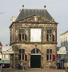
- The Waag (weigh house) - built in 1667 across from the Old City Hall, this building was used for weighing goods (especially cheese) to levy taxes. It now is a national monument. It currently hosts a small cheese museum;
- Grote or St. Jans Kerk (Great or Saint John Church) - longest church in the Netherlands, famous for its stained glass windows which were made between 1530 and 1603, considered the most significant stained glass collection in the Netherlands.[8] Even in the 17th century, it already was a tourist attraction;
- Museum Gouda - museum about the history and arts of the city;
- Verzetsmuseum - museum about the Dutch resistance during World War II;
- Museumhaven Gouda - small harbour with historic ships;
- Goudse Schouwburg - large theatre;
- Waaiersluis (Waaier Locks) - a historic lock on the Hollandse IJssel just east of Gouda.
Events
- Gouda Cheese & Craft Market, every Thursday from 10:00 - 13:00h (April–August)
- Gouda Ceramics Days, yearly two-day event of ceramists from the Netherlands and several other countries. Several exhibitions. May 29 10:00 - 17:00h and May 30 10:00 - 16:00h around the Old City Hall.
- Gouda's Monmartre, antique/curio/flea/collector's market, weekly on Wednesdays around the Old City Hall during summer from June 4 - Sept. 10, 2014.
- Gouda Water City Festival weekend of June 21, 2014
- Gouda by Candlelight - an annual Christmas event held in mid December, featuring attractions in the city centre. In the evening, a Christmas tree, an annual gift from the sister city of Kongsberg, is lit in the market place. Carols are sung by famous Dutch singers accompanied by choirs. The windows of the Old City Hall and the surrounding houses are lit by Gouda candles.
Transport
Gouda is served by two railway stations: Gouda, and Gouda Goverwelle. The main railway station is served by Intercity services to The Hague, Rotterdam and Utrecht and local trains to Amsterdam and Alphen aan den Rijn/Leiden.
The city also lies alongside the A12 and A20 motorways.
International relations
Twin towns — Sister cities
Gouda is twinned with:
-
 Gloucester, Gloucestershire, England, United Kingdom (since 1972)
 -
 Kongsberg, Norway (since 1956)
 -
 Solingen, North Rhine-Westphalia, Germany (since 1957)
Natives of Gouda
- Gerard Leeu (1445–1493), one of the earliest printers (incunabulum period) in North Holland.
- Desiderius Erasmus (1466–1536), philosopher, humanist (though he may also have been born in Rotterdam)
- Adriaan Vlacq (1600–1667), mathematician and publisher.
- Gerard Kamphuisen, who is said to have invented the syrup waffle in 1810
- Pieter Johannes van Rhijn (1886—1960), astronomer.
- Leo Vroman (1915-2014), poet.
- Dick van Dijk (1946–1997), famous football player.
- J. (Hans) van Leeuwen (born 1946), US educator and innovator
- Ad Melkert (born 1956), politician
- Ed de Goey (born 1966), former goalkeeper for the Dutch national soccer team
- Marco de Goeij (born 1967), composer that reconstructed the lost composition Concerto for Group and Orchestra of Jon Lord
- René Van Der Wouden (born 1972), New Age musician
- Andrea Nuyt (born 1974), ice skater
- Margrieta Wever (born 1978), model and author
- Paulien van Deutekom (born 1981), ice skater
- Léon de Jong (born 1982), politician
- Jill Olijhoek (born 1994) - Dutch radio personality
Notes
- ↑ "Burgemeester Milo Schoenmaker" [Mayor Milo Schoenmaker] (in Dutch). Gemeente Gouda. Retrieved 22 July 2013.
- ↑ "Kerncijfers wijken en buurten" [Key figures for neighbourhoods]. CBS Statline (in Dutch). CBS. 2 July 2013. Retrieved 12 March 2014.
- ↑ "Postcodetool for 2801JM". Actueel Hoogtebestand Nederland (in Dutch). Het Waterschapshuis. Retrieved 22 July 2013.
- ↑ "Bevolkingsontwikkeling; regio per maand" [Population growth; regions per month]. CBS Statline (in Dutch). CBS. 26 June 2014. Retrieved 24 July 2014.
- ↑ Abels, pp. 302-303
- ↑ Abels, pp. 364-365
- ↑ Schouten, Jan (1977) Gouda door de eeuwen (Gouda through the ages) Repro-Holland, Alphen aan de Rijn, NL, pg. 156 OCLC 63324059 in Dutch
- ↑ Harten-Boers, Henny van: The stained-glass windows in the Sint Janskerk at Gouda I Archived May 26, 2007, at the Wayback Machine.
References
- Abels, P.H.A.M. (2002) Duizend jaar Gouda: een stadsgeschiedenis (Thousand year Gouda: A history of the city) Verloren, Hilversum, ISBN 90-6550-717-5, in Dutch
- Denslagen, W.F. and Akkerman, Chris (2001) Gouda Rijksdienst voor de Monumentenzorg, Zeist, NL, ISBN 90-400-9515-9, in Dutch
- Lourens, Piet; Lucassen, Jan (1997). Inwonertallen van Nederlandse steden ca. 1300–1800. Amsterdam: NEHA. ISBN 9057420082.
- Schouten, Jan and de Wit, Bob (1960) Gouda (translated from the Dutch by Flora van Os-Gammon) W. van Hoeve, The Hague OCLC 1492541, in English
External links
- Official website for the city of Gouda (in Dutch)
- A collection of old pictures and drawings of Gouda. (A journey through the past)
- Virtual Tour of St. Johns church (Sint Janskerk) Gouda
-
 Chisholm, Hugh, ed. (1911). "Gouda". Encyclopædia Britannica. 12 (11th ed.). Cambridge University Press. p. 280.
 |
Waddinxveen | Bodegraven-Reeuwijk | | |
| |
||||
| ||||
| | ||||
| Zuidplas | Ouderkerk | Vlist |
