Vlaardingen
| Vlaardingen | |||
|---|---|---|---|
| Municipality | |||
|
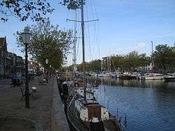
Old harbour in the centre of Vlaardingen | |||
| |||
| Nickname(s): Haringstad (Herring town) | |||
.svg.png) Location in South Holland | |||
| Coordinates: 51°54′N 4°21′E / 51.900°N 4.350°ECoordinates: 51°54′N 4°21′E / 51.900°N 4.350°E | |||
| Country | Netherlands | ||
| Province | South Holland | ||
| Government[1] | |||
| • Body | Municipal council | ||
| • Mayor (interim) | Bert Blase (PvdA) | ||
| Area[2] | |||
| • Total | 26.69 km2 (10.31 sq mi) | ||
| • Land | 23.64 km2 (9.13 sq mi) | ||
| • Water | 3.05 km2 (1.18 sq mi) | ||
| Elevation[3] | 1 m (3 ft) | ||
| Population (May 2014)[4] | |||
| • Total | 71,338 | ||
| • Density | 3,018/km2 (7,820/sq mi) | ||
| Demonym(s) | Vlaardinger | ||
| Time zone | CET (UTC+1) | ||
| • Summer (DST) | CEST (UTC+2) | ||
| Postcode | 3130–3138 | ||
| Area code | 010 | ||
| Website |
www | ||


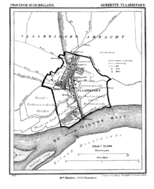
Vlaardingen (Dutch pronunciation: [ˈvlaːrdɪŋə(n)]) is a city in South Holland in the Netherlands. It is located on the north bank of the Nieuwe Maas river at the confluence with the Oude Maas. The municipality administers an area of 26.69 km2 (10.31 sq mi), of which 23.64 km2 (9.13 sq mi) is land, with 71,338 residents in 2014.
Geography
The city is divided into a northern (locally known as the "Holy") and a southern part by the A20 motorway. On the east the city is (currently in part) separated from Schiedam by the A4 motorway. Other places nearby are Maassluis to the west, Schipluiden and Delft to the north, Schiedam and Rotterdam to the east and Spijkenisse in the south-west, on the other side of the Nieuwe Maas. The A20 connects Rotterdam to Hoek van Holland. The Beneluxtunnel (the tunnel that runs under the Nieuwe Waterweg) connects the A20 to the A15.
The centre of the town is on the west side of the old harbour, which is originally a stream ('De Vlaarding') from the peat lands north and east of the town, running to the Meuse estuary.
History
The area around Vlaardingen was already settled by about 2900 to 2600 BC. In 1990, a skeleton dated at about 1300 BC was dug up in the periphery of Vlaardingen; some human nuclear DNA was identified, the oldest found anywhere in the Netherlands. Although in the Roman Age a stronghold or maybe even a vicus Flenio must have been found in nowadays Vlaardingen, between roughly 250 AD and 700 AD the region seems to have been uninhabited, like much of the west of the Netherlands. In 726 or 727 the area is again mentioned as In Pagio Marsum, where a little church was established, around which Vlaardingen formed. The church is mentioned on a list of churches Willibrord, the Apostle to the Frisians, inhered to the Abbey of Echternach.
In 1018 Vlaardingen was a stronghold of Dirk III, who levied an illegal toll on ships on the Meuse river. An army sent by German Emperor Henry II in order to stop this practice was defeated by Dirk III in the (First) Battle of Vlaardingen. In 1047, his successor Dirk IV repelled another such attack (Second Battle of Vlaardingen).
The flood disaster of December 21, 1163 (Saint Thomas Flood), ended the growth of Vlaardingen. The Counts of Holland moved away and its development stagnated.
It is known that in 1273 Vlaardingen was granted city rights by Floris V, Count of Holland. Older city rights are possible, but not provable.
In 1574, during the Eighty Years War of Dutch independence, a group of Watergeuzen burnt down Vlaardingen as commanded by William of Orange to prevent the Spanish from capturing the town. Vlaardingen later became a shipbuilding area and a significant harbour for the herring fishing industry. The fishing boats (originally "haringbuizen", later also "sloepen" and "loggers") ceased to use Vlaardingen in the years after World War II.
In 1855 the former municipality of Zouteveen was merged into the municipality Vlaardingerambacht which in turn was merged with Vlaardingen during the occupation of the Netherlands in the Second World War by the Germans in 1941.
Because of the industrialization in and close to Vlaardingen, the city suffered from heavy air pollution and sometimes sick making smog during the 1970s. One day, a high school had to be closed because of the smog. Many environmental groups arose in and around Vlaardingen and the it was seen as one of the most dirty cities of the country.
Vlaardingen consists of 8 districts/neighbourhoods:
- Vlaardingen Centrum
- Westwijk
- Vettenoordse polder (includes industry)
- Vlaardingen Oost
- Ambacht/Babberspolder
- Holy Zuid
- Holy Noord
- Broekpolder
Politics
Interim Mayor: Bert Blase (PvdA)
Seats in the city council after the municipal elections in 2010:
- Labour Party (PvdA), 6 seats
- Vlaardingen Ahead 2000/Livable Vlaardingen (VV2000/LV), 6 seats
- Groenlinks (GL), 4 seats
- People's Party for Freedom and Democracy (VVD), 4 seats
- Christian Democratic Appeal (CDA), 3 seats
- Socialist Party (SP), 3 seats
- Democrats 66 (D66), 2 seats
- Christian Union/Political Reformed Party (CU/SGP), 2 seats
- City Interests Vlaardingen (SBV), 2 seats
- Proud of the Netherlands (TON), 2 seats
- General Elderly Alliance (AOV), 1 seat
Economy
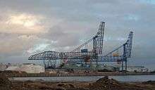
A Unilever research centre is located in Vlaardingen (located next to the former Sunlight factory, later called Lever Faberge Sourcing Unit Vlaardingen). There are still some ship repair business(es) in Eastern Vlaardingen beside the Nieuwe Maas River. The Vulcaanhaven was for many years the largest privately owned artificial harbour in the world. The last major herring factory, Warmelo & Van Der Drift, left Vlaardingen in the middle of 2012 to relocate to Katwijk aan Zee.[5] There are still some ferry terminals (DFDS Seaways, sailing to Felixstowe and Immingham and P&O Ferries sailing to Hull).
Attractions
Monuments
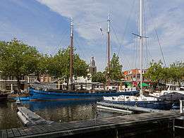
Historical buildings in the town include the Grote Kerk (Big Church), the Waag (Weighing Bridge) next to the church and the old town hall (used for weddings), all on the Markt, the former marketplace, the Visbank (Fish Auction) at the harbour and the Oude Lijnbaan (Old Ropewalk, where ropes were made). The Grote Kerk was probably established between 1156 and 1164 and has been expanded, damaged and rebuilt. To the north of the old harbour is the old Aeolus) windmill, which operates and sells ground cereals. The harbour is a marina and open-air museum with old ships. At the harbour is the Museum Vlaardingen (before: Visserijmuseum and the Visserij en Vlaardings Museum), a museum dedicated to commercial sea fishing and lore. A war memorial to the crew of a Wellington bomber killed when it was shot down over Vlaardingen in March 1942 has recently been erected.
Events
The " Vlaardings Loggerfestival"[6] (it should be noted that Logger is a traditional ship used for herring fishery, the customary English name is Lugger) is held on the first Saturday of June. The festival used to be called "Haring en Bierfeest" (translation: herring and beer festival), but in 2003 the mayor decided to rename it. In 2015, the name "Haring en Bierfeest" reappeared again.
Notable residents
People who are born in or (have) lived in Vlaardingen:
- Agnes van Ardenne, politician (Christian Democratic Appeal)
- Paul-Jan Bakker, former Dutch cricketer
- Bassie en Adriaan, (brothers) actors in a children's TV show
- Gerrit Berveling, theologian and Esperanto poet
- Wouter Bos, former Deputy Prime Minister, former Minister of Finance during Balkenende IV Government (Labour Party)
- Edith Bosch, judoka
- Gerard Callenburgh, vice admiral and town councillor (later mayor)
- Rajacenna van Dam, pencil drawing artist
- Arjan El Fassed, politician (GreenLeft), development aid worker and human rights activist
- Wilma van Hofwegen, swimmer
- Andries Hoogerwerf, middle-distance runner, scientist and conservationist
- Mark Huizinga, olympic gold medal winner in judo
- Juliette Bergmann, IFBB professional bodybuilder
- Rudie Liebrechts, speed skater and cyclist
- Geert Mak, author and journalist
- Karen Mulder, former supermodel
- Martijn LeNoble, bassplayer (amongst others The Cult and Porno for Pyros)
- Roel Pieper, internet businessman, Professor of Electronic Commerce, former director at Philips
- Pieter Kornelis Roest, led Civil Rights Committee for the new Japanese constitution following World War II
- Ericus Verkade, manufacturer
- Harald Wapenaar, professional football player for Sparta Rotterdam
Cornelis Moerman was a general practitioner and keen pigeon fancier who lived and practiced in Vlaardingen. He observed that his pigeons did not suffer from common cancers in humans. He concluded that this was due to their diet. He then started prescribing this diet to people at risk of cancer. As there never has been any scientific proof, the treatment is considered quackery, although it still has a strong following among nutritionists. Local bakeries still sell "Moerman bread". After the Second World War he was believed to have antisemitic views and pro-Germany leanings, discrediting him even further.[7]
Twin city
Gallery
 View to the town: tower Lucaskerk and apartment building in town centre
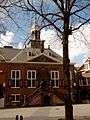
Old town hall 1650 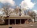
Visbank, covered fish market 
Oude Havenbrug 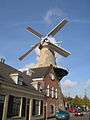
1790 windmill Aeolus 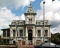
Villa "IJzermans" 1884 ship owners mansion 
Villa "Francina" 1899 Art Nouveau mansion 
Municipal archive building, former town hall Vlaardingerambacht 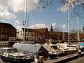
View of the harbour 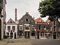 Office building: H van Toor
See also
References
- ↑ "Burgemeester Bert Blase" [Mayor Bert Blase] (in Dutch). Gemeente Vlaardingen. Retrieved 4 August 2014.
- ↑ "Kerncijfers wijken en buurten" [Key figures for neighbourhoods]. CBS Statline (in Dutch). CBS. 2 July 2013. Retrieved 12 March 2014.
- ↑ "Postcodetool for 3133AV". Actueel Hoogtebestand Nederland (in Dutch). Het Waterschapshuis. Retrieved 25 August 2013.
- ↑ "Bevolkingsontwikkeling; regio per maand" [Population growth; regions per month]. CBS Statline (in Dutch). CBS. 26 June 2014. Retrieved 24 July 2014.
- ↑ News on the regional TV station website
- ↑ (Dutch) The Loggerfestival website
- ↑ (Dutch) Cornelis Moerman in the Dutch language Wikipedia
External links
| Wikimedia Commons has media related to Vlaardingen. |
- (Dutch) Official website (English version)
- (Dutch) The history of Vlaardingen website
 |
Midden-Delfland | | ||
| Maassluis | |
Schiedam | ||
| ||||
| | ||||
| Het Scheur, Nieuwe Maas Rotterdam |
