Rhenen
| Rhenen | |||
|---|---|---|---|
| City and Municipality | |||
|
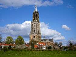
The Cunera Church in Rhenen | |||
| |||
.svg.png) Location in Utrecht | |||
| Coordinates: 51°58′N 5°34′E / 51.967°N 5.567°ECoordinates: 51°58′N 5°34′E / 51.967°N 5.567°E | |||
| Country | Netherlands | ||
| Province | Utrecht | ||
| Government[1] | |||
| • Body | Municipal council | ||
| • Mayor | Hans van der Pas (PvdA) | ||
| Area[2] | |||
| • Municipality | 43.76 km2 (16.90 sq mi) | ||
| • Land | 42.08 km2 (16.25 sq mi) | ||
| • Water | 1.68 km2 (0.65 sq mi) | ||
| Elevation[3] | 43 m (141 ft) | ||
| Population (May 2014)[4] | |||
| • Municipality | 19,164 | ||
| • Density | 455/km2 (1,180/sq mi) | ||
| Demonym(s) | Rhenenaar | ||
| Time zone | CET (UTC+1) | ||
| • Summer (DST) | CEST (UTC+2) | ||
| Postcode | 3910–3922 | ||
| Area code | 0317, 0318 | ||
| Website |
www | ||


Rhenen (![]() pronunciation ) is a municipality and a town in the central Netherlands.
The municipality also includes the villages of Achterberg, Remmerden, Elst and Laareind. The town lies at a geographically interesting location, namely on the southernmost part of the chain of hills known as the Utrecht Hill Ridge (Utrechtse Heuvelrug), where this meets the river Rhine. Because of this Rhenen has a unique character with quite some elevation through town.
pronunciation ) is a municipality and a town in the central Netherlands.
The municipality also includes the villages of Achterberg, Remmerden, Elst and Laareind. The town lies at a geographically interesting location, namely on the southernmost part of the chain of hills known as the Utrecht Hill Ridge (Utrechtse Heuvelrug), where this meets the river Rhine. Because of this Rhenen has a unique character with quite some elevation through town.
Directly to the east of the built-up area lies the Grebbeberg, a hill with a top elevation of about 50 metres (160 ft).
History
Before 1900
Rhenen received city rights probably between 1256 and 1258.[5][6] In 1346, the bishop of Utrecht ordered the construction of a defensive wall around the city, which was important because it lay near the border with Guelders. Although for some time the town collected toll from ships on the Rhine, it has never had a harbour. The three city gates were demolished in 1840. Small fragments of the wall remain.
The town is also famous for the Cunera Church, parts of which date back to the 15th century. Containing the relics of Saint Cunera, it attracted many pilgrims. Legend has it that Cunera was buried on a nearby hill now called the Cuneraheuvel. The church's tower was built between 1492 and 1531.
In 1621, a palace was constructed at Rhenen for the ousted Frederick V. It was demolished in 1812.
World War II
Part of the center of Rhenen, which was located near the defensive Grebbelinie (Grebbe line), was destroyed during the German attack on the Netherlands in May 1940. Part of the reconstruction took place during the war. In 1945, the town was damaged again during the liberation of the country from German occupation.
Many or all of the Dutch soldiers who were killed by the Germans near Rhenen lie buried at the Erebegraafplaats (Cemetery of Honor), located along the Grebbeweg (N 225) near the top of the Grebbeberg. Across the road is an important war monument with a poem by J.C. Bloem.
In 2008 Rhenen celebrated its 750th anniversary.
Main sights
- Ouwehands Dierenpark, a zoo, founded in 1932.
- The Cunera Church, a late-Gothic hall-church, built between 1492-1531.
- Modern Roman Catholic church Gedachteniskerk, built between 1958-1959.
- Building 'De Brakke' from 1787.
- Ruins of the 14th century Medieval defensive wall.
- The Binnenmolen, a round gristmill from 1893.
- The Prattenburg estate.
- Ereveld Rhenen, a military cemetery on the Grebbeberg.
Transport
References
- ↑ "Burgemeester drs. J.H.A. van Oostrum" (in Dutch). Gemeente Rhenen. Retrieved 9 April 2014.
- ↑ "Kerncijfers wijken en buurten" [Key figures for neighbourhoods]. CBS Statline (in Dutch). CBS. 2 July 2013. Retrieved 12 March 2014.
- ↑ "Postcodetool for 3911MG". Actueel Hoogtebestand Nederland (in Dutch). Het Waterschapshuis. Retrieved 9 April 2014.
- ↑ "Bevolkingsontwikkeling; regio per maand" [Population growth; regions per month]. CBS Statline (in Dutch). CBS. 26 June 2014. Retrieved 24 July 2014.
- ↑ Kolman C., et al. (1996). Monumenten in Nederland: Utrecht. Zwolle: Waanders Uitgevers. ISBN 90-400-9757-7.
- ↑ Ph. J. van Dael, 'Over het Rhenense stadsrecht en het Rhenense (burger)zegel', in Oud Rhenen, 2002 no. 2, p. 5-38.
External links
| Wikimedia Commons has media related to Rhenen. |
 |
Veenendaal | Ede (GE) | | |
| Utrechtse Heuvelrug | |
Wageningen (GE) | ||
| ||||
| | ||||
| Lek Buren (GE) |
|
Lek Neder-Betuwe (GE) |
Municipalities of Utrecht | ||
|---|---|---|
 | ||
| ||